Hirm elevation
Hirm (Burgenland, Politischer Bezirk Mattersburg), Austria elevation is 180 meters and Hirm elevation in feet is 591 ft above sea level [src 1]. Hirm is a seat of a third-order administrative division (feature code) with elevation that is 329 meters (1079 ft) smaller than average city elevation in Austria.
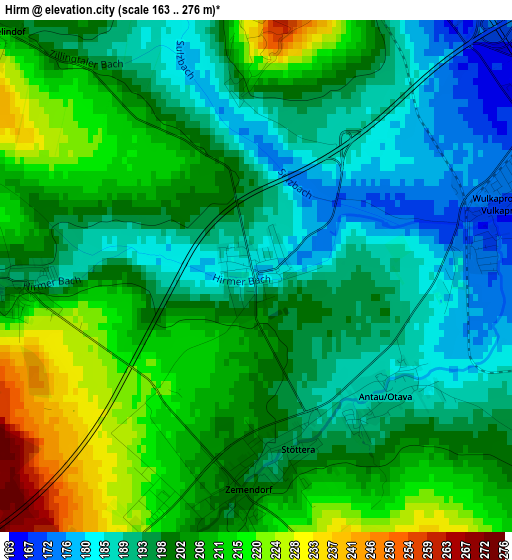
Below is the Elevation map of Hirm, which displays elevation range with different colors. Scale of the first map is from 163 to 276 m (535 to 906 ft) with average elevation of 201 meters (=659 ft) [note 1]
These maps also provides idea of topography and contour of this city, they are displayed at different zoom levels. More info about maps, scale and edge coordinates you can find below images.
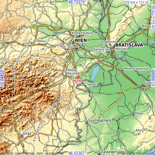
| \ | Map #1 | Topo.Map |
| Scale [m] | 163..276 m | × |
| Scale [ft] | 535..906 ft | × |
| Average | 201 m = 659 ft | × |
| Width | 6.57 km = 4.1 mi | 210.1 km = 130.5 mi |
| Height | 6.57 km = 4.1 mi | 210.1 km = 130.5 mi |
| ↑Max Latitude | 47.816038° | 48.72279° |
| Latitude at center | 47.78652° | 47.78652° |
| ↓Min Latitude | 47.756985° | 46.83307° |
| ← Min Longitude | 16.410655° | 15.04835° |
| Longitude center | 16.4546° | 16.4546° |
| →Max Longitude | 16.498545° | 17.86085° |
Nearby cities:
Cities around Hirm sort by population:
• Pöttsching elevation 218 m
6.5 km,  287°
287°
• Steinbrunn 211 m
5.9 km,  331°
331°
• Grosshöflein 212 m
5.8 km,  19°
19°
• Wulkaprodersdorf 167 m
3.9 km,  71°
71°
• Müllendorf 233 m
5.9 km,  5°
5°
• Drassburg 233 m
5.1 km,  151°
151°
• Sigless 208 m
4.6 km,  254°
254°
• Zagersdorf 179 m
5 km,  118°
118°
• Zillingtal 214 m
4.6 km,  312°
312°
• Antau 185 m
2.4 km,  126°
126°
• Pöttelsdorf 209 m
3.8 km,  198°
198°
• Krensdorf 194 m
3 km,  267°
267°
Multilingual:
 En español:
Hirm elevación 180 m.
 En France:
Hirm élévation 180 m.


Sources and notes:
- [note 1] Map square and city borders are not equal. Map elevation data is calculated only from area inside that square.
- [src 1] Elevation data from geonames database provided with same terms of usage.
- [src 2] The elevation map of Hirm is generated using elevation data from NASA's 3 arcsec (90m) resolution SRTM data.
- [src 3] Base (background) map © OpenStreetMap contributors tiles are generated by Geofabrik and OpenTopoMap.
Copyright & License:
This Hirm Elevation Map is licensed under CC BY-SA. You may reuse any part from this page, if you give a proper credit by linking to this URL:
 More info on terms of use page.