Aguilares elevation
Aguilares (Tucuman, Departamento de Río Chico), Argentina elevation is 375 meters and Aguilares elevation in feet is 1230 ft above sea level [src 1]. Aguilares is a seat of a second-order administrative division (feature code) with elevation that is 25 meters (82 ft) bigger than average city elevation in Argentina.
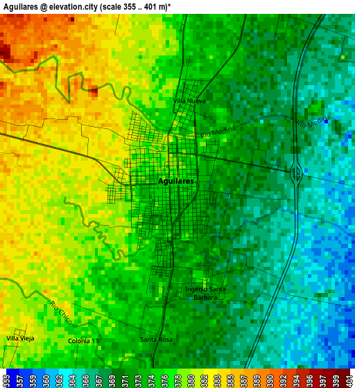
Below is the Elevation map of Aguilares, which displays elevation range with different colors. Scale of the first map is from 355 to 401 m (1165 to 1316 ft) with average elevation of 374.2 meters (=1228 ft) [note 1]
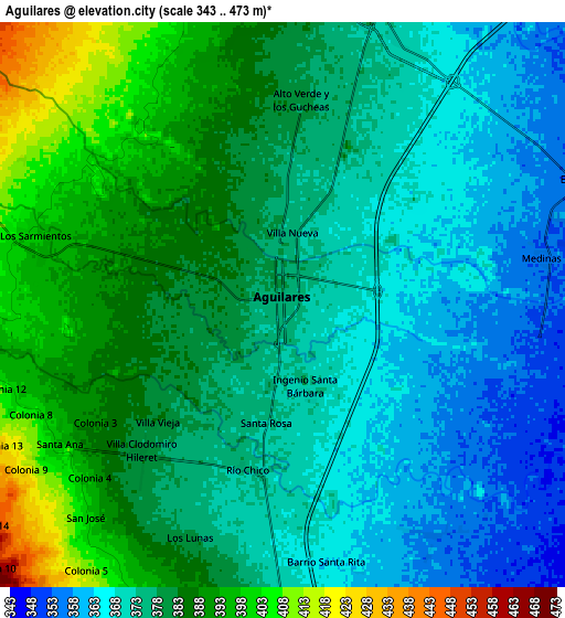
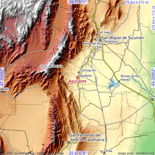
These maps also provides idea of topography and contour of this city, they are displayed at different zoom levels. More info about maps, scale and edge coordinates you can find below images.
| \ | Map #1 | Map #2 | Topo.Map |
| Scale [m] | 355..401 m | 343..473 m | × |
| Scale [ft] | 1165..1316 ft | 1125..1552 ft | × |
| Average | 374.2 m = 1228 ft | 377.7 m = 1239 ft | × |
| Width | 8.67 km = 5.4 mi | 17.35 km = 10.8 mi | 277.5 km = 172.4 mi |
| Height | 8.67 km = 5.4 mi | 17.35 km = 10.8 mi | 277.5 km = 172.4 mi |
| ↑Max Latitude | -27.39479° | -27.355766° | -26.17871° |
| Latitude at center | -27.4338° | -27.4338° | -27.4338° |
| ↓Min Latitude | -27.472796° | -27.511779° | -28.67478° |
| ← Min Longitude | -65.658215° | -65.702161° | -67.02052° |
| Longitude center | -65.61427° | -65.61427° | -65.61427° |
| →Max Longitude | -65.570325° | -65.526379° | -64.20802° |
Nearby cities:
Cities around Aguilares sort by population:
• Famaillá elevation 368 m
47.1 km,  26°
26°
• Monteros 360 m
31.8 km,  21°
21°
• Bella Vista 366 m
54.1 km, 34°
• Simoca 325 m
31.8 km,  53°
53°
• La Cocha 445 m
37.4 km,  175°
175°
• Los Altos 499 m
69.3 km,  170°
170°
• Graneros 326 m
29.6 km,  144°
144°
• San Antonio 1038 m
64.7 km,  188°
188°
• Tafí del Valle 2000 m
65.3 km,  351°
351°
• Los Varela 1178 m
60.7 km,  204°
204°
• San Isidro de Lules 418 m
62.5 km, 25°
• Concepción 374 m
10.4 km,  9°
9°
Multilingual:
 En español:
Aguilares elevación 375 m.
 En France:
Aguilares élévation 375 m.
 Auf Deutsch:
Aguilares höhe über dem Meeresspiegel ist 375 m.

Sources and notes:
- [note 1] Map square and city borders are not equal. Map elevation data is calculated only from area inside that square.
- [src 1] Elevation data from geonames database provided with same terms of usage.
- [src 2] The elevation map of Aguilares is generated using elevation data from NASA's 3 arcsec (90m) resolution SRTM data.
- [src 3] Base (background) map © OpenStreetMap contributors tiles are generated by Geofabrik and OpenTopoMap.
Copyright & License:
This Aguilares Elevation Map is licensed under CC BY-SA. You may reuse any part from this page, if you give a proper credit by linking to this URL:
 More info on terms of use page.