San Antonio elevation
San Antonio (Catamarca, Departamento de Paclín), Argentina elevation is 1038 meters and San Antonio elevation in feet is 3406 ft above sea level [src 1]. San Antonio is a populated place (feature code) with elevation that is 688 meters (2257 ft) bigger than average city elevation in Argentina.
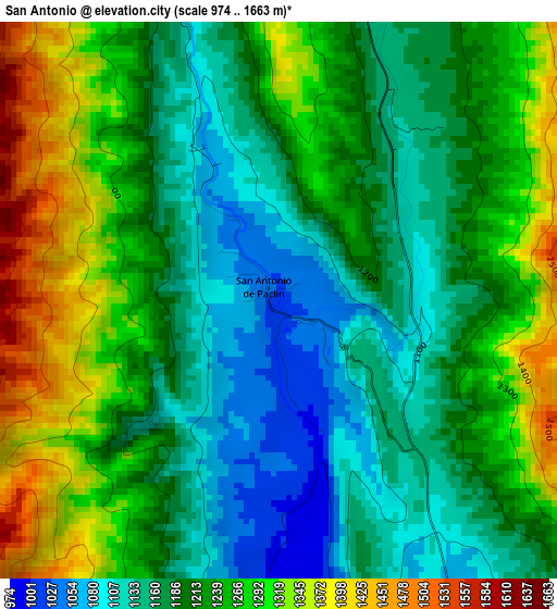
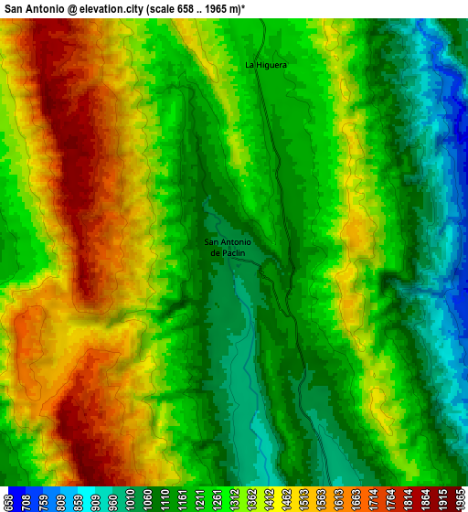
Below is the Elevation map of San Antonio, which displays elevation range with different colors. Scale of the first map is from 974 to 1663 m (3196 to 5456 ft) with average elevation of 1220.9 meters (=4006 ft) [note 1]
These maps also provides idea of topography and contour of this city, they are displayed at different zoom levels. More info about maps, scale and edge coordinates you can find below images.
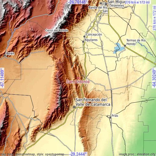
| \ | Map #1 | Map #2 | Topo.Map |
| Scale [m] | 974..1663 m | 658..1965 m | × |
| Scale [ft] | 3196..5456 ft | 2159..6447 ft | × |
| Average | 1220.9 m = 4006 ft | 1284 m = 4213 ft | × |
| Width | 8.63 km = 5.4 mi | 17.26 km = 10.7 mi | 276.1 km = 171.6 mi |
| Height | 8.63 km = 5.4 mi | 17.26 km = 10.7 mi | 276.1 km = 171.6 mi |
| ↑Max Latitude | -27.971285° | -27.932467° | -26.76148° |
| Latitude at center | -28.01009° | -28.01009° | -28.01009° |
| ↓Min Latitude | -28.048881° | -28.087658° | -29.2444° |
| ← Min Longitude | -65.752685° | -65.796631° | -67.11499° |
| Longitude center | -65.70874° | -65.70874° | -65.70874° |
| →Max Longitude | -65.664795° | -65.620849° | -64.30249° |
Nearby cities:
Cities around San Antonio sort by population:
• San Fernando del Valle de Catamarca elevation 545 m
51.6 km,  188°
188°
• La Cocha 445 m
29.3 km,  24°
24°
• Los Altos 499 m
21 km,  101°
101°
• Graneros 326 m
48.1 km,  33°
33°
• Los Varela 1178 m
18.3 km,  299°
299°
• El Rodeo 1296 m
28 km,  215°
215°
• San Isidro 518 m
50.3 km,  181°
181°
• El Alto 977 m
47.6 km,  134°
134°
• San José 584 m
41.5 km, 178°
• Bañado de Ovanta 474 m
39.7 km,  105°
105°
• La Puerta 892 m
19.5 km,  204°
204°
• La Merced 887 m
16.5 km,  163°
163°
Multilingual:
 En español:
San Antonio elevación 1038 m.
 En France:
San Antonio élévation 1038 m.
 Auf Deutsch:
San Antonio höhe über dem Meeresspiegel ist 1038 m.

Sources and notes:
- [note 1] Map square and city borders are not equal. Map elevation data is calculated only from area inside that square.
- [src 1] Elevation data from geonames database provided with same terms of usage.
- [src 2] The elevation map of San Antonio is generated using elevation data from NASA's 3 arcsec (90m) resolution SRTM data.
- [src 3] Base (background) map © OpenStreetMap contributors tiles are generated by Geofabrik and OpenTopoMap.
Copyright & License:
This San Antonio Elevation Map is licensed under CC BY-SA. You may reuse any part from this page, if you give a proper credit by linking to this URL:
 More info on terms of use page.