Andalgalá elevation
Andalgalá (Catamarca, Departamento de Andalgalá), Argentina elevation is 1020 meters and Andalgalá elevation in feet is 3346 ft above sea level [src 1]. Andalgalá is a seat of a second-order administrative division (feature code) with elevation that is 670 meters (2198 ft) bigger than average city elevation in Argentina.
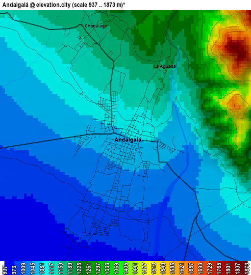
Below is the Elevation map of Andalgalá, which displays elevation range with different colors. Scale of the first map is from 937 to 1873 m (3074 to 6145 ft) with average elevation of 1111.4 meters (=3646 ft) [note 1]
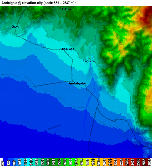
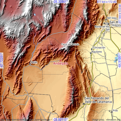
These maps also provides idea of topography and contour of this city, they are displayed at different zoom levels. More info about maps, scale and edge coordinates you can find below images.
| \ | Map #1 | Map #2 | Topo.Map |
| Scale [m] | 937..1873 m | 851..2637 m | × |
| Scale [ft] | 3074..6145 ft | 2792..8652 ft | × |
| Average | 1111.4 m = 3646 ft | 1185.8 m = 3890 ft | × |
| Width | 8.66 km = 5.4 mi | 17.32 km = 10.8 mi | 277.2 km = 172.2 mi |
| Height | 8.66 km = 5.4 mi | 17.32 km = 10.8 mi | 277.2 km = 172.2 mi |
| ↑Max Latitude | -27.542892° | -27.50392° | -26.32841° |
| Latitude at center | -27.58185° | -27.58185° | -27.58185° |
| ↓Min Latitude | -27.620794° | -27.659724° | -28.82113° |
| ← Min Longitude | -66.360205° | -66.404151° | -67.72251° |
| Longitude center | -66.31626° | -66.31626° | -66.31626° |
| →Max Longitude | -66.272315° | -66.228369° | -64.91001° |
Nearby cities:
Cities around Andalgalá sort by population:
• Aguilares elevation 375 m
71.2 km,  76°
76°
• La Cocha 445 m
74.8 km,  106°
106°
• San Antonio 1038 m
76.4 km,  128°
128°
• Londres 1222 m
81.8 km,  259°
259°
• Hualfín 1842 m
64.2 km,  307°
307°
• Los Varela 1178 m
58.4 km, 131°
• Puerta de Corral Quemado 1884 m
72.6 km,  302°
302°
• El Rodeo 1296 m
82.7 km,  148°
148°
• La Puerta de San José 1434 m
69.1 km,  272°
272°
• Concepción 374 m
75.9 km,  69°
69°
• Belén 1262 m
70.6 km, 263°
• Saujil 895 m
66.7 km,  171°
171°
Multilingual:
 En español:
Andalgalá elevación 1020 m.
 En France:
Andalgalá élévation 1020 m.
 Auf Deutsch:
Andalgalá höhe über dem Meeresspiegel ist 1020 m.

Sources and notes:
- [note 1] Map square and city borders are not equal. Map elevation data is calculated only from area inside that square.
- [src 1] Elevation data from geonames database provided with same terms of usage.
- [src 2] The elevation map of Andalgalá is generated using elevation data from NASA's 3 arcsec (90m) resolution SRTM data.
- [src 3] Base (background) map © OpenStreetMap contributors tiles are generated by Geofabrik and OpenTopoMap.
Copyright & License:
This Andalgalá Elevation Map is licensed under CC BY-SA. You may reuse any part from this page, if you give a proper credit by linking to this URL:
 More info on terms of use page.