Comandante Luis Piedra Buena elevation
Comandante Luis Piedra Buena (Santa Cruz, Departamento de Corpen Aike), Argentina elevation is 12 meters and Comandante Luis Piedra Buena elevation in feet is 39 ft above sea level [src 1]. Comandante Luis Piedra Buena is a populated place (feature code) with elevation that is 338 meters (1109 ft) smaller than average city elevation in Argentina.
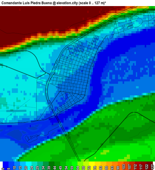
Below is the Elevation map of Comandante Luis Piedra Buena, which displays elevation range with different colors. Scale of the first map is from 0 to 127 m (0 to 417 ft) with average elevation of 39 meters (=128 ft) [note 1]
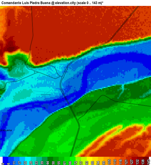
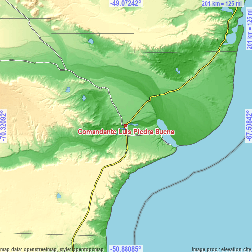
These maps also provides idea of topography and contour of this city, they are displayed at different zoom levels. More info about maps, scale and edge coordinates you can find below images.
| \ | Map #1 | Map #2 | Topo.Map |
| Scale [m] | 0..127 m | 0..143 m | × |
| Scale [ft] | 0..417 ft | 0..469 ft | × |
| Average | 39 m = 128 ft | 66.5 m = 218 ft | × |
| Width | 6.28 km = 3.9 mi | 12.57 km = 7.8 mi | 201.1 km = 125 mi |
| Height | 6.28 km = 3.9 mi | 12.57 km = 7.8 mi | 201.1 km = 125 mi |
| ↑Max Latitude | -49.956865° | -49.928584° | -49.07242° |
| Latitude at center | -49.98513° | -49.98513° | -49.98513° |
| ↓Min Latitude | -50.013378° | -50.041609° | -50.88085° |
| ← Min Longitude | -68.958615° | -69.002561° | -70.32092° |
| Longitude center | -68.91467° | -68.91467° | -68.91467° |
| →Max Longitude | -68.870725° | -68.826779° | -67.50842° |
Nearby cities:
Cities around Comandante Luis Piedra Buena sort by population:
• Río Gallegos elevation 15 m
183.3 km,  186°
186°
• Pico Truncado 286 m
361.7 km,  11°
11°
• Puerto Deseado 31 m
332.5 km,  41°
41°
• Las Heras 336 m
382.9 km,  359°
359°
• El Calafate 205 m
242.7 km,  260°
260°
• Yacimiento Río Turbio 573 m
299.2 km,  233°
233°
• Río Turbio 324 m
296 km, 234°
• San Julián 20 m
114.1 km,  48°
48°
• 28 de Noviembre 227 m
292.2 km, 232°
• Perito Moreno 390 m
405.8 km,  338°
338°
• Puerto Santa Cruz 17 m
28.2 km,  97°
97°
• Gobernador Gregores 289 m
167.8 km,  324°
324°
Multilingual:
 En español:
Comandante Luis Piedra Buena elevación 12 m.
 En France:
Comandante Luis Piedra Buena élévation 12 m.
 Auf Deutsch:
Comandante Luis Piedra Buena höhe über dem Meeresspiegel ist 12 m.
 На русском:
Comandante Luis Piedra Buena высота над уровнем моря 12 м
Sources and notes:
- [note 1] Map square and city borders are not equal. Map elevation data is calculated only from area inside that square.
- [src 1] Elevation data from geonames database provided with same terms of usage.
- [src 2] The elevation map of Comandante Luis Piedra Buena is generated using elevation data from NASA's 3 arcsec (90m) resolution SRTM data.
- [src 3] Base (background) map © OpenStreetMap contributors tiles are generated by Geofabrik and OpenTopoMap.
Copyright & License:
This Comandante Luis Piedra Buena Elevation Map is licensed under CC BY-SA. You may reuse any part from this page, if you give a proper credit by linking to this URL:
 More info on terms of use page.