Perito Moreno elevation
Perito Moreno (Santa Cruz, Departamento de Lago Buenos Aires), Argentina elevation is 390 meters and Perito Moreno elevation in feet is 1280 ft above sea level [src 1]. Perito Moreno is a seat of a second-order administrative division (feature code) with elevation that is 40 meters (131 ft) bigger than average city elevation in Argentina.
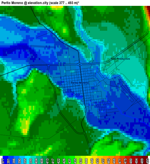
Below is the Elevation map of Perito Moreno, which displays elevation range with different colors. Scale of the first map is from 377 to 493 m (1237 to 1617 ft) with average elevation of 404.9 meters (=1328 ft) [note 1]
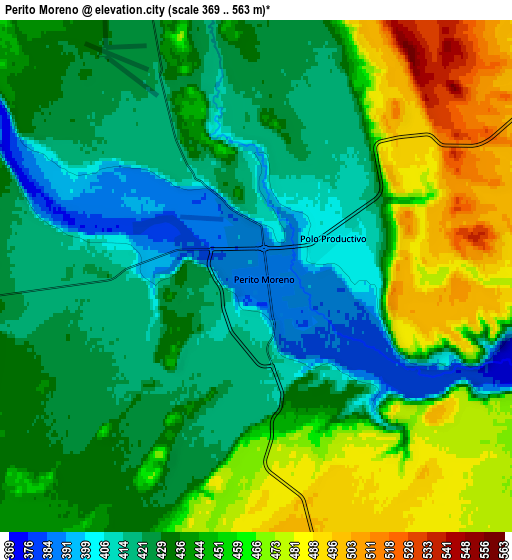
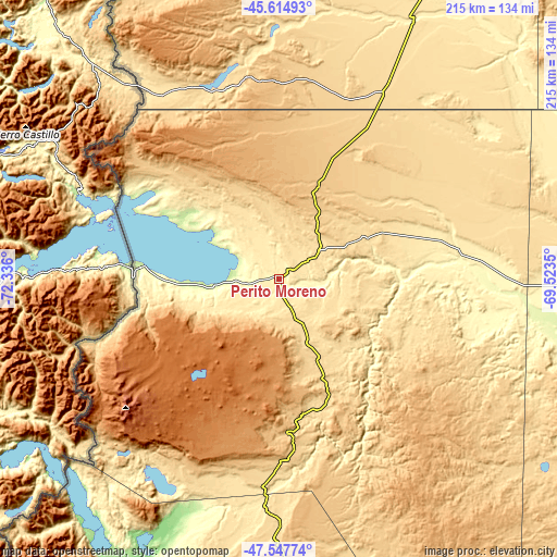
These maps also provides idea of topography and contour of this city, they are displayed at different zoom levels. More info about maps, scale and edge coordinates you can find below images.
| \ | Map #1 | Map #2 | Topo.Map |
| Scale [m] | 377..493 m | 369..563 m | × |
| Scale [ft] | 1237..1617 ft | 1211..1847 ft | × |
| Average | 404.9 m = 1328 ft | 439.4 m = 1442 ft | × |
| Width | 6.72 km = 4.2 mi | 13.43 km = 8.3 mi | 214.9 km = 133.5 mi |
| Height | 6.72 km = 4.2 mi | 13.43 km = 8.3 mi | 214.9 km = 133.5 mi |
| ↑Max Latitude | -46.559742° | -46.529517° | -45.61493° |
| Latitude at center | -46.58995° | -46.58995° | -46.58995° |
| ↓Min Latitude | -46.620141° | -46.650316° | -47.54774° |
| ← Min Longitude | -70.973695° | -71.017641° | -72.336° |
| Longitude center | -70.92975° | -70.92975° | -70.92975° |
| →Max Longitude | -70.885805° | -70.841859° | -69.5235° |
Nearby cities:
Cities around Perito Moreno sort by population:
• Comodoro Rivadavia elevation 65 m
276.1 km,  73°
73°
• Caleta Olivia 17 m
260.8 km,  86°
86°
• Pico Truncado 286 m
227.8 km,  95°
95°
• Las Heras 336 m
152.5 km, 87°
• Sarmiento 274 m
181.6 km,  52°
52°
• Rada Tilly 9 m
269.8 km, 74°
• Río Mayo 430 m
113.1 km,  27°
27°
• Gobernador Costa 721 m
283.6 km,  5°
5°
• Los Antiguos 218 m
53.8 km,  274°
274°
• Alto Río Senguer 697 m
172.4 km,  2°
2°
• Río Pico 603 m
270.2 km,  352°
352°
• Gobernador Gregores 289 m
245.6 km,  167°
167°
Multilingual:
 En español:
Perito Moreno elevación 390 m.
 En France:
Perito Moreno élévation 390 m.
 Auf Deutsch:
Perito Moreno höhe über dem Meeresspiegel ist 390 m.

Sources and notes:
- [note 1] Map square and city borders are not equal. Map elevation data is calculated only from area inside that square.
- [src 1] Elevation data from geonames database provided with same terms of usage.
- [src 2] The elevation map of Perito Moreno is generated using elevation data from NASA's 3 arcsec (90m) resolution SRTM data.
- [src 3] Base (background) map © OpenStreetMap contributors tiles are generated by Geofabrik and OpenTopoMap.
Copyright & License:
This Perito Moreno Elevation Map is licensed under CC BY-SA. You may reuse any part from this page, if you give a proper credit by linking to this URL:
 More info on terms of use page.