Deán Funes elevation
Deán Funes (Cordoba, Departamento de Ischilín), Argentina elevation is 691 meters and Deán Funes elevation in feet is 2267 ft above sea level [src 1]. Deán Funes is a seat of a second-order administrative division (feature code) with elevation that is 341 meters (1119 ft) bigger than average city elevation in Argentina.
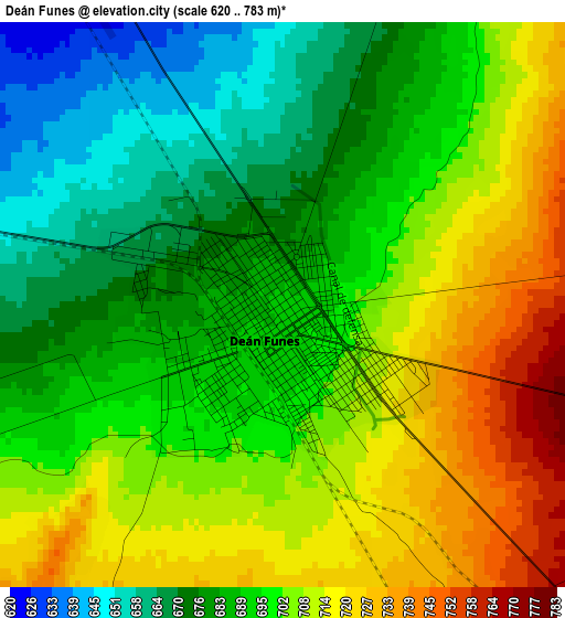
Below is the Elevation map of Deán Funes, which displays elevation range with different colors. Scale of the first map is from 620 to 783 m (2034 to 2569 ft) with average elevation of 696.3 meters (=2284 ft) [note 1]
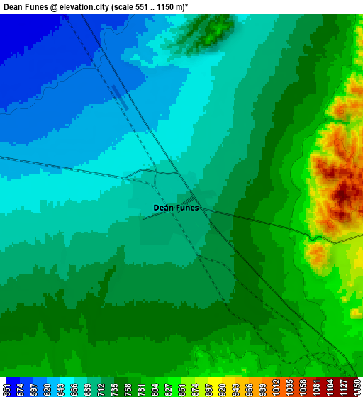
These maps also provides idea of topography and contour of this city, they are displayed at different zoom levels. More info about maps, scale and edge coordinates you can find below images.
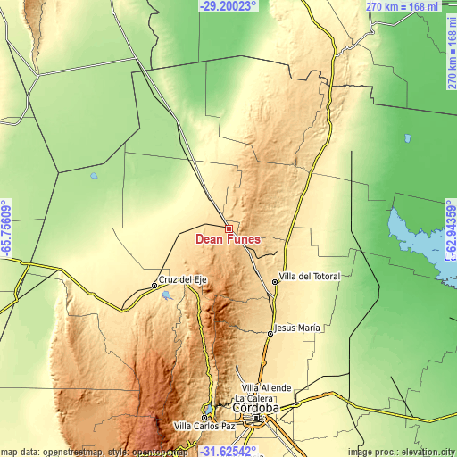
| \ | Map #1 | Map #2 | Topo.Map |
| Scale [m] | 620..783 m | 551..1150 m | × |
| Scale [ft] | 2034..2569 ft | 1808..3773 ft | × |
| Average | 696.3 m = 2284 ft | 725.4 m = 2380 ft | × |
| Width | 8.43 km = 5.2 mi | 16.85 km = 10.5 mi | 269.7 km = 167.6 mi |
| Height | 8.43 km = 5.2 mi | 16.85 km = 10.5 mi | 269.7 km = 167.6 mi |
| ↑Max Latitude | -30.382457° | -30.34454° | -29.20023° |
| Latitude at center | -30.42036° | -30.42036° | -30.42036° |
| ↓Min Latitude | -30.458248° | -30.496122° | -31.62542° |
| ← Min Longitude | -64.393785° | -64.437731° | -65.75609° |
| Longitude center | -64.34984° | -64.34984° | -64.34984° |
| →Max Longitude | -64.305895° | -64.261949° | -62.94359° |
Nearby cities:
Cities around Deán Funes sort by population:
• Cruz del Eje elevation 465 m
55.2 km,  231°
231°
• Jesús María 533 m
67 km,  158°
158°
• Capilla del Monte 984 m
51.8 km,  198°
198°
• La Cumbre 1146 m
63.9 km,  192°
192°
• Villa Giardino 1086 m
69.3 km, 190°
• Quilino 398 m
27.1 km,  327°
327°
• San José de la Dormida 468 m
39.2 km,  79°
79°
• La Granja 695 m
65.9 km,  173°
173°
• Agua de Oro 791 m
72 km,  176°
176°
• Villa Tulumba 702 m
22 km, 82°
• Cañada de Luque 239 m
69.3 km,  120°
120°
• Los Cocos 1179 m
58 km, 194°
Multilingual:
 En español:
Deán Funes elevación 691 m.
 En France:
Deán Funes élévation 691 m.
 Auf Deutsch:
Deán Funes höhe über dem Meeresspiegel ist 691 m.

Sources and notes:
- [note 1] Map square and city borders are not equal. Map elevation data is calculated only from area inside that square.
- [src 1] Elevation data from geonames database provided with same terms of usage.
- [src 2] The elevation map of Deán Funes is generated using elevation data from NASA's 3 arcsec (90m) resolution SRTM data.
- [src 3] Base (background) map © OpenStreetMap contributors tiles are generated by Geofabrik and OpenTopoMap.
Copyright & License:
This Deán Funes Elevation Map is licensed under CC BY-SA. You may reuse any part from this page, if you give a proper credit by linking to this URL:
 More info on terms of use page.