Quilino elevation
Quilino (Cordoba, Departamento de Ischilín), Argentina elevation is 398 meters and Quilino elevation in feet is 1306 ft above sea level [src 1]. Quilino is a populated place (feature code) with elevation that is 48 meters (157 ft) bigger than average city elevation in Argentina.
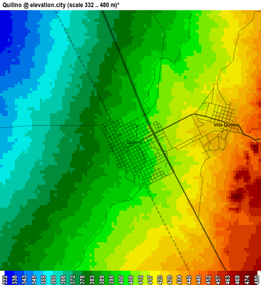
Below is the Elevation map of Quilino, which displays elevation range with different colors. Scale of the first map is from 332 to 480 m (1089 to 1575 ft) with average elevation of 398.5 meters (=1307 ft) [note 1]
These maps also provides idea of topography and contour of this city, they are displayed at different zoom levels. More info about maps, scale and edge coordinates you can find below images.
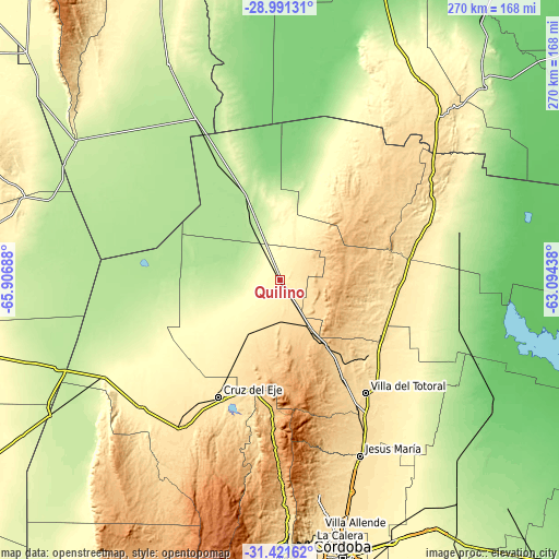
| \ | Map #1 | Map #2 | Topo.Map |
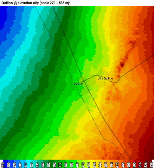
| Scale [m] | 332..480 m | 270..536 m | × |
| Scale [ft] | 1089..1575 ft | 886..1759 ft | × |
| Average | 398.5 m = 1307 ft | 405.4 m = 1330 ft | × |
| Width | 8.44 km = 5.2 mi | 16.89 km = 10.5 mi | 270.2 km = 167.9 mi |
| Height | 8.44 km = 5.2 mi | 16.89 km = 10.5 mi | 270.2 km = 167.9 mi |
| ↑Max Latitude | -30.175987° | -30.13799° | -28.99131° |
| Latitude at center | -30.21397° | -30.21397° | -30.21397° |
| ↓Min Latitude | -30.251938° | -30.289892° | -31.42162° |
| ← Min Longitude | -64.544575° | -64.588521° | -65.90688° |
| Longitude center | -64.50063° | -64.50063° | -64.50063° |
| →Max Longitude | -64.456685° | -64.412739° | -63.09438° |
Nearby cities:
Cities around Quilino sort by population:
• Cruz del Eje elevation 465 m
64 km,  207°
207°
• Deán Funes 691 m
27.1 km,  147°
147°
• Capilla del Monte 984 m
72 km,  181°
181°
• Villa de Soto 538 m
85.8 km, 213°
• La Cumbre 1146 m
85.4 km, 179°
• Villa Giardino 1086 m
91.1 km, 178°
• San José de la Dormida 468 m
55.2 km,  106°
106°
• San Francisco del Chañar 681 m
71.5 km,  48°
48°
• Sebastián Elcano 211 m
87.4 km,  86°
86°
• Villa Tulumba 702 m
41.5 km,  119°
119°
• Los Cocos 1179 m
79.1 km, 180°
• Villa de María 347 m
82.5 km,  65°
65°
Multilingual:
 En español:
Quilino elevación 398 m.
 En France:
Quilino élévation 398 m.


Sources and notes:
- [note 1] Map square and city borders are not equal. Map elevation data is calculated only from area inside that square.
- [src 1] Elevation data from geonames database provided with same terms of usage.
- [src 2] The elevation map of Quilino is generated using elevation data from NASA's 3 arcsec (90m) resolution SRTM data.
- [src 3] Base (background) map © OpenStreetMap contributors tiles are generated by Geofabrik and OpenTopoMap.
Copyright & License:
This Quilino Elevation Map is licensed under CC BY-SA. You may reuse any part from this page, if you give a proper credit by linking to this URL:
 More info on terms of use page.