La Cumbre elevation
La Cumbre (Cordoba, Departamento de Punilla), Argentina elevation is 1146 meters and La Cumbre elevation in feet is 3760 ft above sea level [src 1]. La Cumbre is a populated place (feature code) with elevation that is 796 meters (2612 ft) bigger than average city elevation in Argentina.
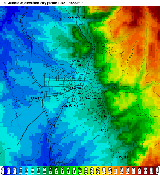
Below is the Elevation map of La Cumbre, which displays elevation range with different colors. Scale of the first map is from 1048 to 1586 m (3438 to 5203 ft) with average elevation of 1209.9 meters (=3969 ft) [note 1]
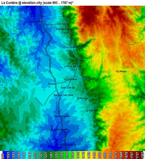
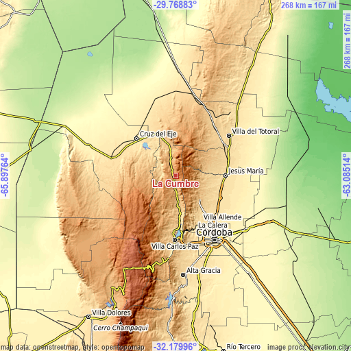
These maps also provides idea of topography and contour of this city, they are displayed at different zoom levels. More info about maps, scale and edge coordinates you can find below images.
| \ | Map #1 | Map #2 | Topo.Map |
| Scale [m] | 1048..1586 m | 993..1767 m | × |
| Scale [ft] | 3438..5203 ft | 3258..5797 ft | × |
| Average | 1209.9 m = 3969 ft | 1271.8 m = 4173 ft | × |
| Width | 8.38 km = 5.2 mi | 16.76 km = 10.4 mi | 268.1 km = 166.6 mi |
| Height | 8.38 km = 5.2 mi | 16.76 km = 10.4 mi | 268.1 km = 166.6 mi |
| ↑Max Latitude | -30.944327° | -30.906629° | -29.76883° |
| Latitude at center | -30.98201° | -30.98201° | -30.98201° |
| ↓Min Latitude | -31.019678° | -31.057331° | -32.17996° |
| ← Min Longitude | -64.535335° | -64.579281° | -65.89764° |
| Longitude center | -64.49139° | -64.49139° | -64.49139° |
| →Max Longitude | -64.447445° | -64.403499° | -63.08514° |
Nearby cities:
Cities around La Cumbre sort by population:
• Cosquín elevation 707 m
29.4 km,  175°
175°
• Río Ceballos 705 m
25.9 km,  141°
141°
• Unquillo 633 m
32.3 km,  148°
148°
• La Falda 947 m
11.8 km, 179°
• Capilla del Monte 984 m
13.8 km,  346°
346°
• Salsipuedes 739 m
25.4 km,  132°
132°
• Huerta Grande 997 m
10.4 km, 179°
• Valle Hermoso 907 m
15.1 km, 176°
• Villa Giardino 1086 m
5.8 km,  172°
172°
• La Granja 695 m
21.4 km,  98°
98°
• Agua de Oro 791 m
20.5 km,  117°
117°
• Los Cocos 1179 m
6.4 km, 350°
Multilingual:
 En español:
La Cumbre elevación 1146 m.
 En France:
La Cumbre élévation 1146 m.
 Auf Deutsch:
La Cumbre höhe über dem Meeresspiegel ist 1146 m.

Sources and notes:
- [note 1] Map square and city borders are not equal. Map elevation data is calculated only from area inside that square.
- [src 1] Elevation data from geonames database provided with same terms of usage.
- [src 2] The elevation map of La Cumbre is generated using elevation data from NASA's 3 arcsec (90m) resolution SRTM data.
- [src 3] Base (background) map © OpenStreetMap contributors tiles are generated by Geofabrik and OpenTopoMap.
Copyright & License:
This La Cumbre Elevation Map is licensed under CC BY-SA. You may reuse any part from this page, if you give a proper credit by linking to this URL:
 More info on terms of use page.