Cosquín elevation
Cosquín (Cordoba, Departamento de Punilla), Argentina elevation is 707 meters and Cosquín elevation in feet is 2320 ft above sea level [src 1]. Cosquín is a seat of a second-order administrative division (feature code) with elevation that is 357 meters (1171 ft) bigger than average city elevation in Argentina.
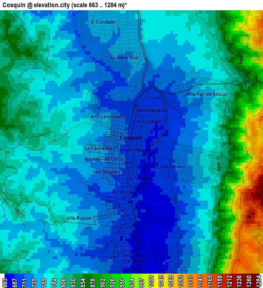
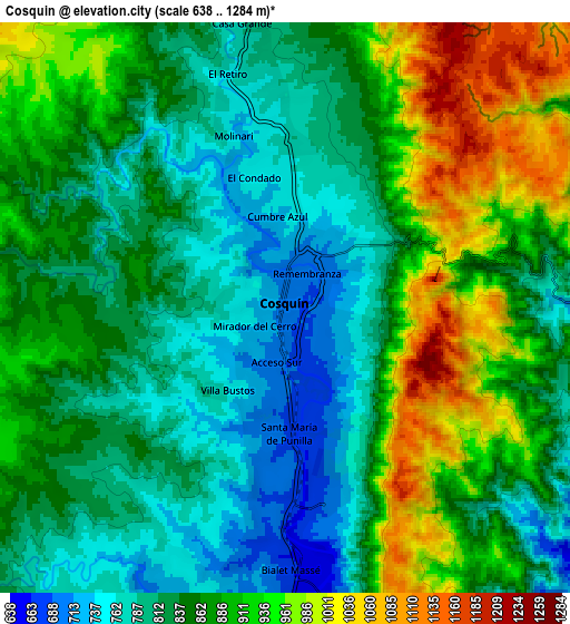
Below is the Elevation map of Cosquín, which displays elevation range with different colors. Scale of the first map is from 663 to 1284 m (2175 to 4213 ft) with average elevation of 786 meters (=2579 ft) [note 1]
These maps also provides idea of topography and contour of this city, they are displayed at different zoom levels. More info about maps, scale and edge coordinates you can find below images.
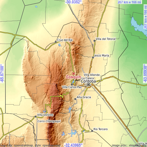
| \ | Map #1 | Map #2 | Topo.Map |
| Scale [m] | 663..1284 m | 638..1284 m | × |
| Scale [ft] | 2175..4213 ft | 2093..4213 ft | × |
| Average | 786 m = 2579 ft | 861.4 m = 2826 ft | × |
| Width | 8.36 km = 5.2 mi | 16.71 km = 10.4 mi | 267.3 km = 166.1 mi |
| Height | 8.36 km = 5.2 mi | 16.71 km = 10.4 mi | 267.4 km = 166.2 mi |
| ↑Max Latitude | -31.207501° | -31.169907° | -30.0352° |
| Latitude at center | -31.24508° | -31.24508° | -31.24508° |
| ↓Min Latitude | -31.282644° | -31.320193° | -32.43965° |
| ← Min Longitude | -64.509575° | -64.553521° | -65.87188° |
| Longitude center | -64.46563° | -64.46563° | -64.46563° |
| →Max Longitude | -64.421685° | -64.377739° | -63.05938° |
Nearby cities:
Cities around Cosquín sort by population:
• Villa Carlos Paz elevation 666 m
20.1 km,  188°
188°
• La Calera 495 m
16.5 km,  131°
131°
• Villa Allende 505 m
17.1 km,  108°
108°
• Río Ceballos 705 m
16.3 km,  56°
56°
• Unquillo 633 m
14.3 km,  83°
83°
• La Falda 947 m
17.6 km,  352°
352°
• Salsipuedes 739 m
20.1 km,  53°
53°
• Huerta Grande 997 m
19 km, 352°
• Valle Hermoso 907 m
14.3 km, 354°
• Villa Giardino 1086 m
23.6 km,  355°
355°
• Mendiolaza 540 m
15.9 km,  98°
98°
• Saldán 495 m
16.4 km, 112°
Multilingual:
 En español:
Cosquín elevación 707 m.
 En France:
Cosquín élévation 707 m.


Sources and notes:
- [note 1] Map square and city borders are not equal. Map elevation data is calculated only from area inside that square.
- [src 1] Elevation data from geonames database provided with same terms of usage.
- [src 2] The elevation map of Cosquín is generated using elevation data from NASA's 3 arcsec (90m) resolution SRTM data.
- [src 3] Base (background) map © OpenStreetMap contributors tiles are generated by Geofabrik and OpenTopoMap.
Copyright & License:
This Cosquín Elevation Map is licensed under CC BY-SA. You may reuse any part from this page, if you give a proper credit by linking to this URL:
 More info on terms of use page.