El Simbolar elevation
El Simbolar (Santiago del Estero, Departamento de Guasayán), Argentina elevation is 507 meters and El Simbolar elevation in feet is 1663 ft above sea level [src 1]. El Simbolar is a seat of a third-order administrative division (feature code) with elevation that is 157 meters (515 ft) bigger than average city elevation in Argentina.
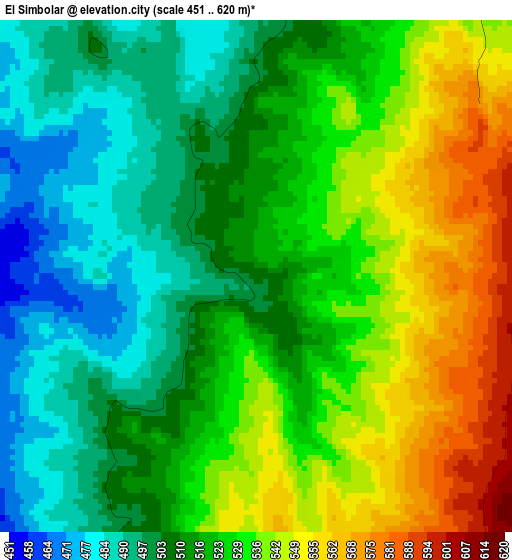
Below is the Elevation map of El Simbolar, which displays elevation range with different colors. Scale of the first map is from 451 to 620 m (1480 to 2034 ft) with average elevation of 521.1 meters (=1710 ft) [note 1]
These maps also provides idea of topography and contour of this city, they are displayed at different zoom levels. More info about maps, scale and edge coordinates you can find below images.
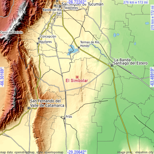
| \ | Map #1 | Topo.Map |
| Scale [m] | 451..620 m | × |
| Scale [ft] | 1480..2034 ft | × |
| Average | 521.1 m = 1710 ft | × |
| Width | 8.63 km = 5.4 mi | 276.2 km = 171.6 mi |
| Height | 8.63 km = 5.4 mi | 276.2 km = 171.6 mi |
| ↑Max Latitude | -27.932851° | -26.72262° |
| Latitude at center | -27.97167° | -27.97167° |
| ↓Min Latitude | -28.010475° | -29.20642° |
| ← Min Longitude | -64.939385° | -66.30169° |
| Longitude center | -64.89544° | -64.89544° |
| →Max Longitude | -64.851495° | -63.48919° |
Nearby cities:
Cities around El Simbolar sort by population:
• Santiago del Estero elevation 188 m
65.3 km,  72°
72°
• Termas de Río Hondo 260 m
53.3 km,  3°
3°
• La Cocha 445 m
71.6 km,  288°
288°
• Los Altos 499 m
59.9 km,  261°
261°
• Graneros 326 m
64.3 km,  303°
303°
• San Pedro 382 m
26.7 km,  274°
274°
• La Merced 887 m
77.7 km, 255°
• Frías 334 m
77.4 km,  197°
197°
• La Banda 193 m
69.4 km, 67°
• Arraga 169 m
66.6 km,  97°
97°
• El Alto 977 m
59.5 km,  230°
230°
• Bañado de Ovanta 474 m
44.1 km,  250°
250°
Multilingual:
 En español:
El Simbolar elevación 507 m.
 En France:
El Simbolar élévation 507 m.
 Auf Deutsch:
El Simbolar höhe über dem Meeresspiegel ist 507 m.

Sources and notes:
- [note 1] Map square and city borders are not equal. Map elevation data is calculated only from area inside that square.
- [src 1] Elevation data from geonames database provided with same terms of usage.
- [src 2] The elevation map of El Simbolar is generated using elevation data from NASA's 3 arcsec (90m) resolution SRTM data.
- [src 3] Base (background) map © OpenStreetMap contributors tiles are generated by Geofabrik and OpenTopoMap.
Copyright & License:
This El Simbolar Elevation Map is licensed under CC BY-SA. You may reuse any part from this page, if you give a proper credit by linking to this URL:
 More info on terms of use page.