Santiago del Estero elevation
Santiago del Estero, Argentina elevation is 188 meters and Santiago del Estero elevation in feet is 617 ft above sea level [src 1]. Santiago del Estero is a seat of a first-order administrative division (feature code) with elevation that is 162 meters (531 ft) smaller than average city elevation in Argentina.
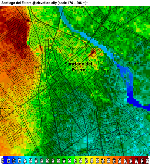
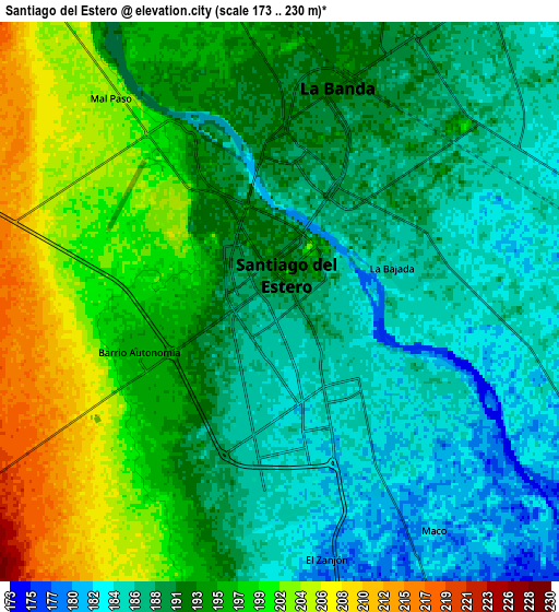
Below is the Elevation map of Santiago del Estero, which displays elevation range with different colors. Scale of the first map is from 176 to 206 m (577 to 676 ft) with average elevation of 189.3 meters (=621 ft) [note 1]
These maps also provides idea of topography and contour of this city, they are displayed at different zoom levels. More info about maps, scale and edge coordinates you can find below images.
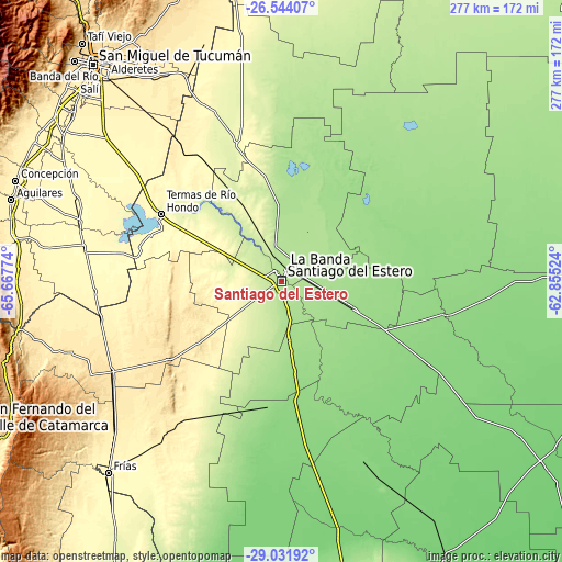
| \ | Map #1 | Map #2 | Topo.Map |
| Scale [m] | 176..206 m | 173..230 m | × |
| Scale [ft] | 577..676 ft | 568..755 ft | × |
| Average | 189.3 m = 621 ft | 192.3 m = 631 ft | × |
| Width | 8.64 km = 5.4 mi | 17.29 km = 10.7 mi | 276.6 km = 171.9 mi |
| Height | 8.64 km = 5.4 mi | 17.29 km = 10.7 mi | 276.6 km = 171.9 mi |
| ↑Max Latitude | -27.756228° | -27.717332° | -26.54407° |
| Latitude at center | -27.79511° | -27.79511° | -27.79511° |
| ↓Min Latitude | -27.833978° | -27.872832° | -29.03192° |
| ← Min Longitude | -64.305435° | -64.349381° | -65.66774° |
| Longitude center | -64.26149° | -64.26149° | -64.26149° |
| →Max Longitude | -64.217545° | -64.173599° | -62.85524° |
Nearby cities:
Cities around Santiago del Estero sort by population:
• Termas de Río Hondo elevation 260 m
67.8 km,  299°
299°
• Clodomira 180 m
27.7 km,  27°
27°
• Suncho Corral 135 m
83.2 km,  100°
100°
• Beltrán 172 m
20.1 km, 100°
• Garza 130 m
81.3 km,  119°
119°
• Pozo Hondo 266 m
73.5 km,  342°
342°
• El Simbolar 507 m
65.3 km,  252°
252°
• Brea Pozo 143 m
58.5 km,  148°
148°
• La Cañada 156 m
49 km,  78°
78°
• Fernández 155 m
38.8 km,  111°
111°
• Arraga 169 m
28.6 km,  172°
172°
• La Banda 193 m
7.1 km,  15°
15°
Multilingual:
 En español:
Ciudad de Santiago del Estero elevación 188 m.
 En France:
Santiago del Estero élévation 188 m.
 Auf Deutsch:
Santiago del Estero höhe über dem Meeresspiegel ist 188 m.
 На русском:
Сантьяго-дель-Эстеро высота над уровнем моря 188 м
Sources and notes:
- [note 1] Map square and city borders are not equal. Map elevation data is calculated only from area inside that square.
- [src 1] Elevation data from geonames database provided with same terms of usage.
- [src 2] The elevation map of Santiago del Estero is generated using elevation data from NASA's 3 arcsec (90m) resolution SRTM data.
- [src 3] Base (background) map © OpenStreetMap contributors tiles are generated by Geofabrik and OpenTopoMap.
Copyright & License:
This Santiago del Estero Elevation Map is licensed under CC BY-SA. You may reuse any part from this page, if you give a proper credit by linking to this URL:
 More info on terms of use page.