Frías elevation
Frías (Santiago del Estero, Departamento de Choya), Argentina elevation is 334 meters and Frías elevation in feet is 1096 ft above sea level [src 1]. Frías is a seat of a second-order administrative division (feature code) with elevation that is 16 meters (52 ft) smaller than average city elevation in Argentina.
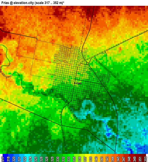
Below is the Elevation map of Frías, which displays elevation range with different colors. Scale of the first map is from 317 to 352 m (1040 to 1155 ft) with average elevation of 335.2 meters (=1100 ft) [note 1]
These maps also provides idea of topography and contour of this city, they are displayed at different zoom levels. More info about maps, scale and edge coordinates you can find below images.
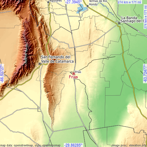
| \ | Map #1 | Topo.Map |
| Scale [m] | 317..352 m | × |
| Scale [ft] | 1040..1155 ft | × |
| Average | 335.2 m = 1100 ft | × |
| Width | 8.58 km = 5.3 mi | 274.5 km = 170.6 mi |
| Height | 8.58 km = 5.3 mi | 274.5 km = 170.6 mi |
| ↑Max Latitude | -28.597353° | -27.3945° |
| Latitude at center | -28.63593° | -28.63593° |
| ↓Min Latitude | -28.674493° | -29.86285° |
| ← Min Longitude | -65.174965° | -66.53727° |
| Longitude center | -65.13102° | -65.13102° |
| →Max Longitude | -65.087075° | -63.72477° |
Nearby cities:
Cities around Frías sort by population:
• San Fernando del Valle de Catamarca elevation 545 m
66.5 km,  286°
286°
• Recreo 216 m
72.1 km,  174°
174°
• Icaño 358 m
36.9 km,  211°
211°
• Los Altos 499 m
74.6 km,  331°
331°
• Ancasti 883 m
41.1 km,  241°
241°
• San Pedro 382 m
75.9 km,  357°
357°
• El Simbolar 507 m
77.4 km,  17°
17°
• La Merced 887 m
74.7 km,  316°
316°
• San José 584 m
62.3 km,  296°
296°
• Bañado de Ovanta 474 m
61.8 km,  342°
342°
• San Isidro 518 m
61.2 km, 288°
• El Alto 977 m
42.7 km, 327°
Multilingual:
 En español:
Frías elevación 334 m.
 En France:
Frías élévation 334 m.


Sources and notes:
- [note 1] Map square and city borders are not equal. Map elevation data is calculated only from area inside that square.
- [src 1] Elevation data from geonames database provided with same terms of usage.
- [src 2] The elevation map of Frías is generated using elevation data from NASA's 3 arcsec (90m) resolution SRTM data.
- [src 3] Base (background) map © OpenStreetMap contributors tiles are generated by Geofabrik and OpenTopoMap.
Copyright & License:
This Frías Elevation Map is licensed under CC BY-SA. You may reuse any part from this page, if you give a proper credit by linking to this URL:
 More info on terms of use page.