Los Juríes elevation
Los Juríes (Santiago del Estero, Departamento de General Taboada), Argentina elevation is 93 meters and Los Juríes elevation in feet is 305 ft above sea level [src 1]. Los Juríes is a populated place (feature code) with elevation that is 257 meters (843 ft) smaller than average city elevation in Argentina.
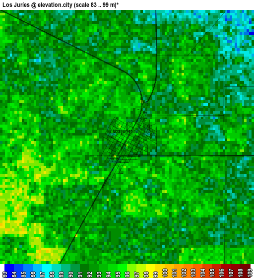
Below is the Elevation map of Los Juríes, which displays elevation range with different colors. Scale of the first map is from 83 to 99 m (272 to 325 ft) with average elevation of 92.2 meters (=302 ft) [note 1]
These maps also provides idea of topography and contour of this city, they are displayed at different zoom levels. More info about maps, scale and edge coordinates you can find below images.
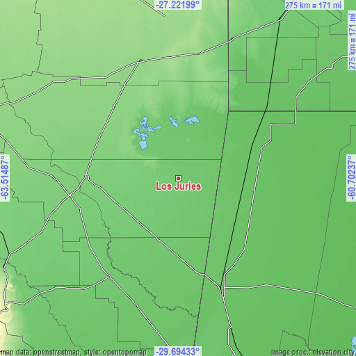
| \ | Map #1 | Topo.Map |
| Scale [m] | 83..99 m | × |
| Scale [ft] | 272..325 ft | × |
| Average | 92.2 m = 302 ft | × |
| Width | 8.59 km = 5.3 mi | 274.9 km = 170.8 mi |
| Height | 8.59 km = 5.3 mi | 274.9 km = 170.8 mi |
| ↑Max Latitude | -28.42675° | -27.22199° |
| Latitude at center | -28.46539° | -28.46539° |
| ↓Min Latitude | -28.504015° | -29.69433° |
| ← Min Longitude | -62.152565° | -63.51487° |
| Longitude center | -62.10862° | -62.10862° |
| →Max Longitude | -62.064675° | -60.70237° |
Nearby cities:
Cities around Los Juríes sort by population:
• Añatuya elevation 111 m
71 km,  270°
270°
• Tostado 77 m
91.4 km,  158°
158°
• Quimilí 135 m
96 km,  341°
341°
• Santa Sylvina 77 m
118.4 km,  53°
53°
• Hermoso Campo 86 m
121.3 km,  38°
38°
• Gancedo 105 m
116.4 km,  21°
21°
• Villa General Mitre 90 m
92.1 km,  215°
215°
• Colonia Dora 107 m
83.5 km,  259°
259°
• Chorotis 76 m
92.5 km, 48°
• Gato Colorado 71 m
102.9 km,  61°
61°
• Herrera 111 m
93.8 km, 268°
• Bandera 97 m
49.5 km,  198°
198°
Multilingual:
 En español:
Los Juríes elevación 93 m.
 En France:
Los Juríes élévation 93 m.
 Auf Deutsch:
Los Juríes höhe über dem Meeresspiegel ist 93 m.

Sources and notes:
- [note 1] Map square and city borders are not equal. Map elevation data is calculated only from area inside that square.
- [src 1] Elevation data from geonames database provided with same terms of usage.
- [src 2] The elevation map of Los Juríes is generated using elevation data from NASA's 3 arcsec (90m) resolution SRTM data.
- [src 3] Base (background) map © OpenStreetMap contributors tiles are generated by Geofabrik and OpenTopoMap.
Copyright & License:
This Los Juríes Elevation Map is licensed under CC BY-SA. You may reuse any part from this page, if you give a proper credit by linking to this URL:
 More info on terms of use page.