Añatuya elevation
Añatuya (Santiago del Estero, Departamento de General Taboada), Argentina elevation is 111 meters and Añatuya elevation in feet is 364 ft above sea level [src 1]. Añatuya is a seat of a second-order administrative division (feature code) with elevation that is 239 meters (784 ft) smaller than average city elevation in Argentina.
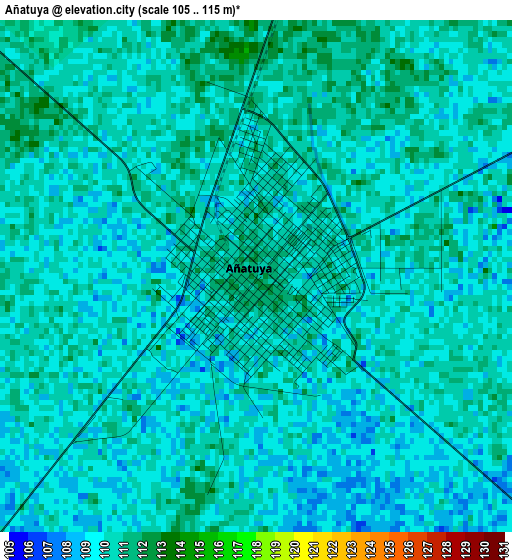
Below is the Elevation map of Añatuya, which displays elevation range with different colors. Scale of the first map is from 105 to 115 m (344 to 377 ft) with average elevation of 109.6 meters (=360 ft) [note 1]
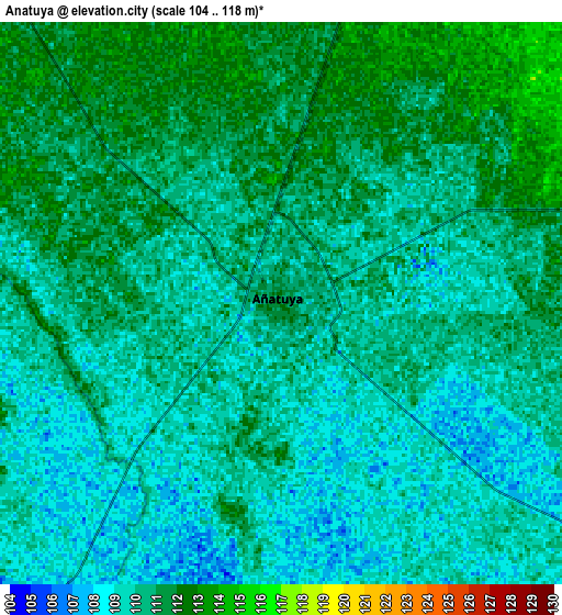
These maps also provides idea of topography and contour of this city, they are displayed at different zoom levels. More info about maps, scale and edge coordinates you can find below images.
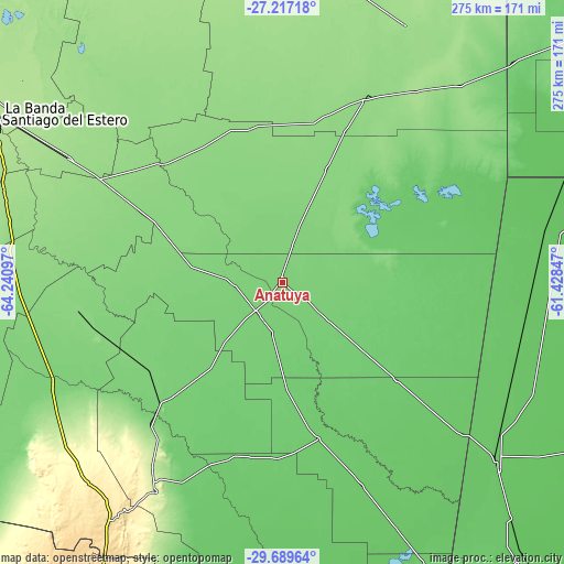
| \ | Map #1 | Map #2 | Topo.Map |
| Scale [m] | 105..115 m | 104..118 m | × |
| Scale [ft] | 344..377 ft | 341..387 ft | × |
| Average | 109.6 m = 360 ft | 109.9 m = 361 ft | × |
| Width | 8.59 km = 5.3 mi | 17.18 km = 10.7 mi | 274.9 km = 170.8 mi |
| Height | 8.59 km = 5.3 mi | 17.18 km = 10.7 mi | 274.9 km = 170.8 mi |
| ↑Max Latitude | -28.421999° | -28.383343° | -27.21718° |
| Latitude at center | -28.46064° | -28.46064° | -28.46064° |
| ↓Min Latitude | -28.499267° | -28.53788° | -29.68964° |
| ← Min Longitude | -62.878665° | -62.922611° | -64.24097° |
| Longitude center | -62.83472° | -62.83472° | -62.83472° |
| →Max Longitude | -62.790775° | -62.746829° | -61.42847° |
Nearby cities:
Cities around Añatuya sort by population:
• Quimilí elevation 135 m
99.4 km,  24°
24°
• Suncho Corral 135 m
82.6 km,  315°
315°
• Villa General Mitre 90 m
77.9 km,  166°
166°
• Los Juríes 93 m
71 km,  90°
90°
• Villa Atamisqui 124 m
96 km,  267°
267°
• Colonia Dora 107 m
19.2 km,  216°
216°
• Los Telares 107 m
83.6 km,  225°
225°
• Brea Pozo 143 m
111.8 km,  282°
282°
• Villa Unión 87 m
106 km,  177°
177°
• Garza 130 m
77 km,  296°
296°
• Bandera 97 m
73.1 km,  130°
130°
• Herrera 111 m
22.9 km,  264°
264°
Multilingual:
 En español:
Añatuya elevación 111 m.
 En France:
Añatuya élévation 111 m.


Sources and notes:
- [note 1] Map square and city borders are not equal. Map elevation data is calculated only from area inside that square.
- [src 1] Elevation data from geonames database provided with same terms of usage.
- [src 2] The elevation map of Añatuya is generated using elevation data from NASA's 3 arcsec (90m) resolution SRTM data.
- [src 3] Base (background) map © OpenStreetMap contributors tiles are generated by Geofabrik and OpenTopoMap.
Copyright & License:
This Añatuya Elevation Map is licensed under CC BY-SA. You may reuse any part from this page, if you give a proper credit by linking to this URL:
 More info on terms of use page.