Patquía elevation
Patquía (La Rioja, Departamento de Independencia), Argentina elevation is 435 meters and Patquía elevation in feet is 1427 ft above sea level [src 1]. Patquía is a seat of a second-order administrative division (feature code) with elevation that is 85 meters (279 ft) bigger than average city elevation in Argentina.
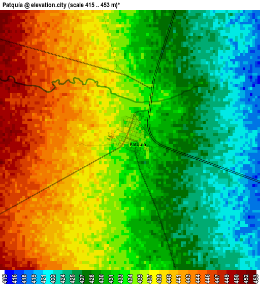
Below is the Elevation map of Patquía, which displays elevation range with different colors. Scale of the first map is from 415 to 453 m (1362 to 1486 ft) with average elevation of 433.7 meters (=1423 ft) [note 1]
These maps also provides idea of topography and contour of this city, they are displayed at different zoom levels. More info about maps, scale and edge coordinates you can find below images.
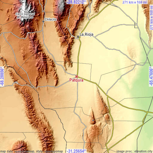
| \ | Map #1 | Topo.Map |
| Scale [m] | 415..453 m | × |
| Scale [ft] | 1362..1486 ft | × |
| Average | 433.7 m = 1423 ft | × |
| Width | 8.46 km = 5.3 mi | 270.7 km = 168.2 mi |
| Height | 8.46 km = 5.3 mi | 270.7 km = 168.2 mi |
| ↑Max Latitude | -30.008763° | -28.82212° |
| Latitude at center | -30.04681° | -30.04681° |
| ↓Min Latitude | -30.084842° | -31.25654° |
| ← Min Longitude | -66.926255° | -68.28856° |
| Longitude center | -66.88231° | -66.88231° |
| →Max Longitude | -66.838365° | -65.47606° |
Nearby cities:
Cities around Patquía sort by population:
• La Rioja elevation 502 m
70.8 km,  2°
2°
• Chilecito 1125 m
115 km,  328°
328°
• Chamical 473 m
64.8 km,  122°
122°
• San Agustín de Valle Fértil 856 m
86.1 km,  220°
220°
• Castro Barros 236 m
125.7 km, 118°
• Villa Bustos 989 m
85.6 km,  351°
351°
• Milagro 377 m
136.8 km,  141°
141°
• Aminga 1388 m
133.4 km,  358°
358°
• Sañogasta 2012 m
108.2 km, 347°
• Malanzán 889 m
88.2 km,  162°
162°
• Olta 520 m
88.1 km, 137°
• Tama 654 m
61.4 km,  146°
146°
Multilingual:
 En español:
Patquía elevación 435 m.
 En France:
Patquía élévation 435 m.


Sources and notes:
- [note 1] Map square and city borders are not equal. Map elevation data is calculated only from area inside that square.
- [src 1] Elevation data from geonames database provided with same terms of usage.
- [src 2] The elevation map of Patquía is generated using elevation data from NASA's 3 arcsec (90m) resolution SRTM data.
- [src 3] Base (background) map © OpenStreetMap contributors tiles are generated by Geofabrik and OpenTopoMap.
Copyright & License:
This Patquía Elevation Map is licensed under CC BY-SA. You may reuse any part from this page, if you give a proper credit by linking to this URL:
 More info on terms of use page.