San Agustín de Valle Fértil elevation
San Agustín de Valle Fértil (San Juan, Departamento de Valle Fértil), Argentina elevation is 856 meters and San Agustín de Valle Fértil elevation in feet is 2808 ft above sea level [src 1]. San Agustín de Valle Fértil is a seat of a second-order administrative division (feature code) with elevation that is 506 meters (1660 ft) bigger than average city elevation in Argentina.
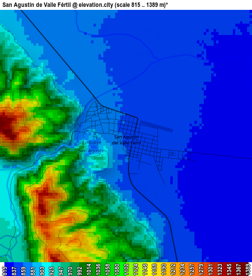
Below is the Elevation map of San Agustín de Valle Fértil, which displays elevation range with different colors. Scale of the first map is from 815 to 1389 m (2674 to 4557 ft) with average elevation of 914.9 meters (=3002 ft) [note 1]
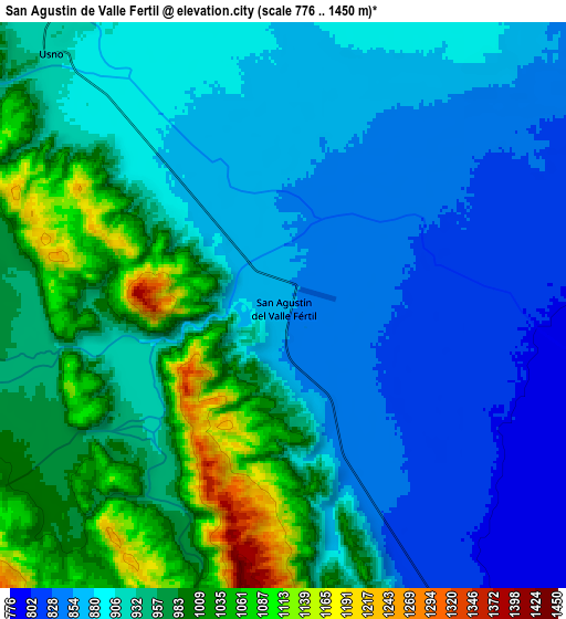
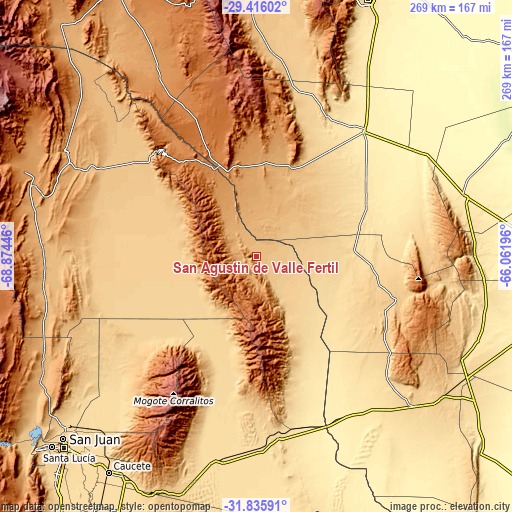
These maps also provides idea of topography and contour of this city, they are displayed at different zoom levels. More info about maps, scale and edge coordinates you can find below images.
| \ | Map #1 | Map #2 | Topo.Map |
| Scale [m] | 815..1389 m | 776..1450 m | × |
| Scale [ft] | 2674..4557 ft | 2546..4757 ft | × |
| Average | 914.9 m = 3002 ft | 923 m = 3028 ft | × |
| Width | 8.41 km = 5.2 mi | 16.82 km = 10.5 mi | 269.1 km = 167.2 mi |
| Height | 8.41 km = 5.2 mi | 16.82 km = 10.5 mi | 269.1 km = 167.2 mi |
| ↑Max Latitude | -30.59571° | -30.557875° | -29.41602° |
| Latitude at center | -30.63353° | -30.63353° | -30.63353° |
| ↓Min Latitude | -30.671335° | -30.709125° | -31.83591° |
| ← Min Longitude | -67.512155° | -67.556101° | -68.87446° |
| Longitude center | -67.46821° | -67.46821° | -67.46821° |
| →Max Longitude | -67.424265° | -67.380319° | -66.06196° |
Nearby cities:
Cities around San Agustín de Valle Fértil sort by population:
• Chimbas elevation 642 m
138.6 km,  227°
227°
• Caucete 578 m
137.1 km,  214°
214°
• San José de Jáchal 1176 m
130.1 km,  289°
289°
• Albardón 641 m
134.7 km, 228°
• Chamical 473 m
114.7 km,  74°
74°
• San Martín 625 m
132.3 km, 228°
• Villa del Salvador 602 m
126.1 km,  224°
224°
• Olta 520 m
115.3 km,  89°
89°
• Chepes 644 m
115.1 km,  133°
133°
• Tama 654 m
90.9 km,  81°
81°
• Patquía 435 m
86.1 km,  40°
40°
• Malanzán 889 m
84.3 km,  102°
102°
Multilingual:
 En español:
San Agustín de Valle Fértil elevación 856 m.
 En France:
San Agustín de Valle Fértil élévation 856 m.
 Auf Deutsch:
San Agustín de Valle Fértil höhe über dem Meeresspiegel ist 856 m.
 На русском:
San Agustín de Valle Fértil высота над уровнем моря 856 м
Sources and notes:
- [note 1] Map square and city borders are not equal. Map elevation data is calculated only from area inside that square.
- [src 1] Elevation data from geonames database provided with same terms of usage.
- [src 2] The elevation map of San Agustín de Valle Fértil is generated using elevation data from NASA's 3 arcsec (90m) resolution SRTM data.
- [src 3] Base (background) map © OpenStreetMap contributors tiles are generated by Geofabrik and OpenTopoMap.
Copyright & License:
This San Agustín de Valle Fértil Elevation Map is licensed under CC BY-SA. You may reuse any part from this page, if you give a proper credit by linking to this URL:
 More info on terms of use page.