Chimbas elevation
Chimbas (San Juan, Departamento de Chimbas), Argentina elevation is 642 meters and Chimbas elevation in feet is 2106 ft above sea level [src 1]. Chimbas is a seat of a second-order administrative division (feature code) with elevation that is 292 meters (958 ft) bigger than average city elevation in Argentina.
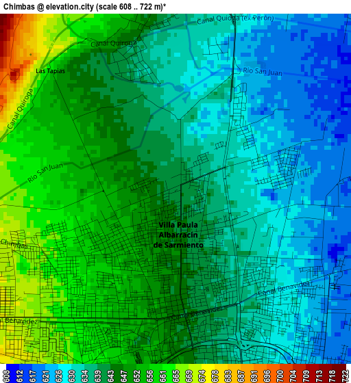
Below is the Elevation map of Chimbas, which displays elevation range with different colors. Scale of the first map is from 608 to 722 m (1995 to 2369 ft) with average elevation of 642.2 meters (=2107 ft) [note 1]
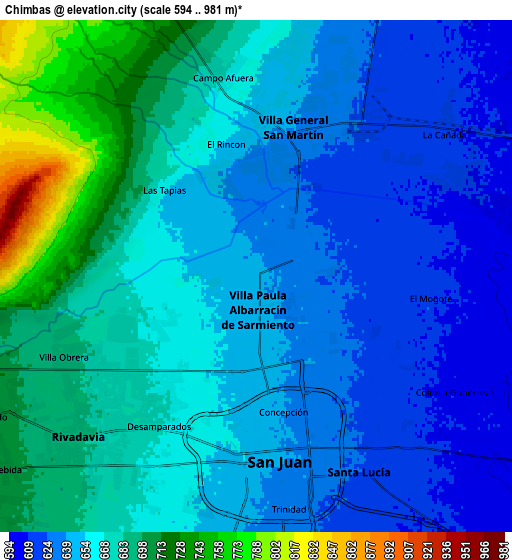
These maps also provides idea of topography and contour of this city, they are displayed at different zoom levels. More info about maps, scale and edge coordinates you can find below images.
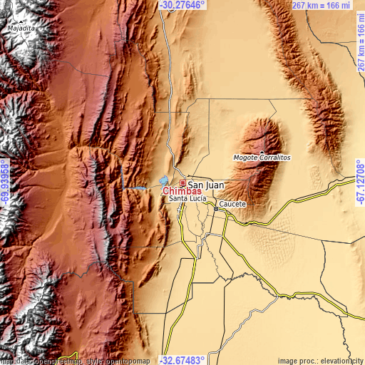
| \ | Map #1 | Map #2 | Topo.Map |
| Scale [m] | 608..722 m | 594..981 m | × |
| Scale [ft] | 1995..2369 ft | 1949..3219 ft | × |
| Average | 642.2 m = 2107 ft | 661 m = 2169 ft | × |
| Width | 8.33 km = 5.2 mi | 16.67 km = 10.4 mi | 266.7 km = 165.7 mi |
| Height | 8.33 km = 5.2 mi | 16.67 km = 10.4 mi | 266.7 km = 165.7 mi |
| ↑Max Latitude | -31.445846° | -31.408348° | -30.27646° |
| Latitude at center | -31.48333° | -31.48333° | -31.48333° |
| ↓Min Latitude | -31.520799° | -31.558252° | -32.67483° |
| ← Min Longitude | -68.577275° | -68.621221° | -69.93958° |
| Longitude center | -68.53333° | -68.53333° | -68.53333° |
| →Max Longitude | -68.489385° | -68.445439° | -67.12708° |
Nearby cities:
Cities around Chimbas sort by population:
• San Juan elevation 649 m
6 km,  182°
182°
• Santa Lucía 620 m
7.3 km,  149°
149°
• Pocito 608 m
22.7 km,  192°
192°
• Albardón 641 m
5.2 km,  8°
8°
• Villa Paula de Sarmiento 646 m
1.2 km,  203°
203°
• San Martín 625 m
6.7 km,  27°
27°
• Nueve de Julio 578 m
24.7 km, 146°
• Villa Basilio Nievas 776 m
20.4 km,  248°
248°
• Villa Aberastain 619 m
19.1 km, 194°
• Rivadavia 734 m
13.8 km,  235°
235°
• Villa del Salvador 602 m
13.7 km,  70°
70°
• Villa Krause 634 m
9.3 km, 180°
Multilingual:
 En español:
Chimbas elevación 642 m.
 En France:
Chimbas élévation 642 m.


Sources and notes:
- [note 1] Map square and city borders are not equal. Map elevation data is calculated only from area inside that square.
- [src 1] Elevation data from geonames database provided with same terms of usage.
- [src 2] The elevation map of Chimbas is generated using elevation data from NASA's 3 arcsec (90m) resolution SRTM data.
- [src 3] Base (background) map © OpenStreetMap contributors tiles are generated by Geofabrik and OpenTopoMap.
Copyright & License:
This Chimbas Elevation Map is licensed under CC BY-SA. You may reuse any part from this page, if you give a proper credit by linking to this URL:
 More info on terms of use page.