Chilecito elevation
Chilecito (La Rioja, Departamento de Chilecito), Argentina elevation is 1125 meters and Chilecito elevation in feet is 3691 ft above sea level [src 1]. Chilecito is a seat of a second-order administrative division (feature code) with elevation that is 775 meters (2543 ft) bigger than average city elevation in Argentina.
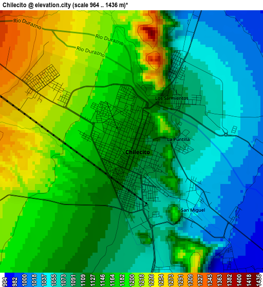
Below is the Elevation map of Chilecito, which displays elevation range with different colors. Scale of the first map is from 964 to 1436 m (3163 to 4711 ft) with average elevation of 1135.6 meters (=3726 ft) [note 1]
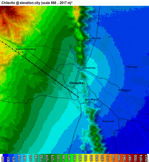
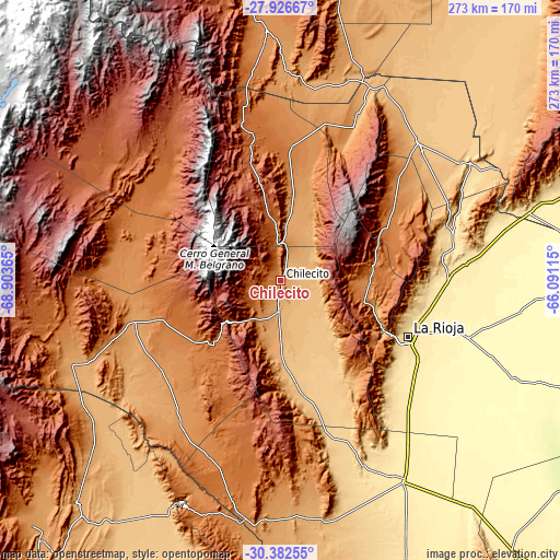
These maps also provides idea of topography and contour of this city, they are displayed at different zoom levels. More info about maps, scale and edge coordinates you can find below images.
| \ | Map #1 | Map #2 | Topo.Map |
| Scale [m] | 964..1436 m | 888..2017 m | × |
| Scale [ft] | 3163..4711 ft | 2913..6617 ft | × |
| Average | 1135.6 m = 3726 ft | 1158.8 m = 3802 ft | × |
| Width | 8.53 km = 5.3 mi | 17.07 km = 10.6 mi | 273.1 km = 169.7 mi |
| Height | 8.53 km = 5.3 mi | 17.07 km = 10.6 mi | 273.1 km = 169.7 mi |
| ↑Max Latitude | -29.123568° | -29.085171° | -27.92667° |
| Latitude at center | -29.16195° | -29.16195° | -29.16195° |
| ↓Min Latitude | -29.200318° | -29.238671° | -30.38255° |
| ← Min Longitude | -67.541345° | -67.585291° | -68.90365° |
| Longitude center | -67.4974° | -67.4974° | -67.4974° |
| →Max Longitude | -67.453455° | -67.409509° | -66.09115° |
Nearby cities:
Cities around Chilecito sort by population:
• La Rioja elevation 502 m
68.6 km,  113°
113°
• Arauco 820 m
94.3 km,  46°
46°
• Vinchina 1460 m
82.3 km,  302°
302°
• Villa Bustos 989 m
48.3 km, 106°
• Patquía 435 m
115 km,  148°
148°
• Aimogasta 846 m
94.9 km, 45°
• San Blas de los Sauces 1022 m
92.4 km,  25°
25°
• Villa Unión 1154 m
72.8 km,  256°
256°
• Villa Castelli 1300 m
72.4 km,  283°
283°
• Aminga 1388 m
65.3 km,  57°
57°
• Sañogasta 2012 m
37.8 km,  78°
78°
• Famatina 1567 m
26.7 km,  355°
355°
Multilingual:
 En español:
Chilecito elevación 1125 m.
 En France:
Chilecito élévation 1125 m.
 Auf Deutsch:
Chilecito höhe über dem Meeresspiegel ist 1125 m.

Sources and notes:
- [note 1] Map square and city borders are not equal. Map elevation data is calculated only from area inside that square.
- [src 1] Elevation data from geonames database provided with same terms of usage.
- [src 2] The elevation map of Chilecito is generated using elevation data from NASA's 3 arcsec (90m) resolution SRTM data.
- [src 3] Base (background) map © OpenStreetMap contributors tiles are generated by Geofabrik and OpenTopoMap.
Copyright & License:
This Chilecito Elevation Map is licensed under CC BY-SA. You may reuse any part from this page, if you give a proper credit by linking to this URL:
 More info on terms of use page.