Rawson elevation
Rawson (Chubut, Departamento de Rawson), Argentina elevation is 13 meters and Rawson elevation in feet is 43 ft above sea level [src 1]. Rawson is a seat of a first-order administrative division (feature code) with elevation that is 337 meters (1106 ft) smaller than average city elevation in Argentina.
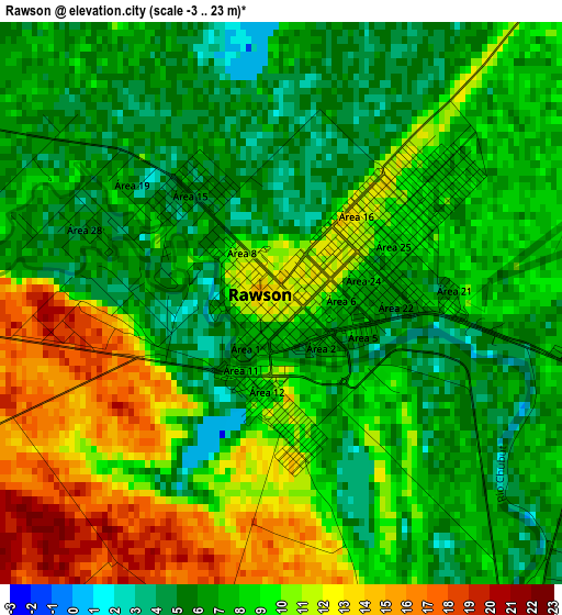
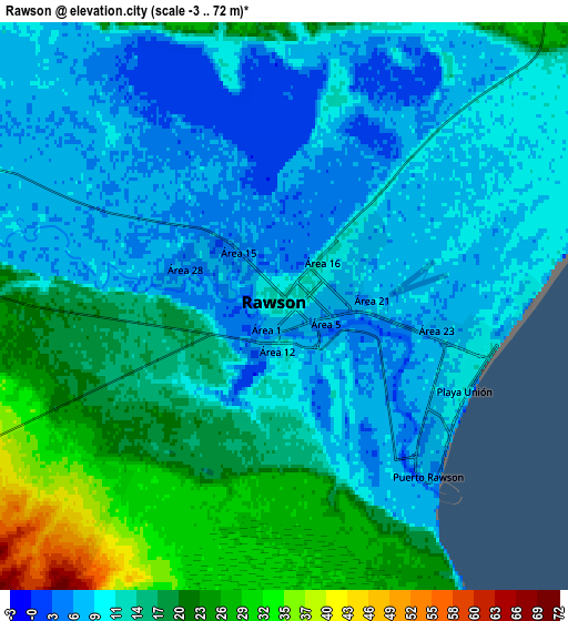
Below is the Elevation map of Rawson, which displays elevation range with different colors. Scale of the first map is from -3 to 23 m (-10 to 75 ft) with average elevation of 8.1 meters (=27 ft) [note 1]
These maps also provides idea of topography and contour of this city, they are displayed at different zoom levels. More info about maps, scale and edge coordinates you can find below images.
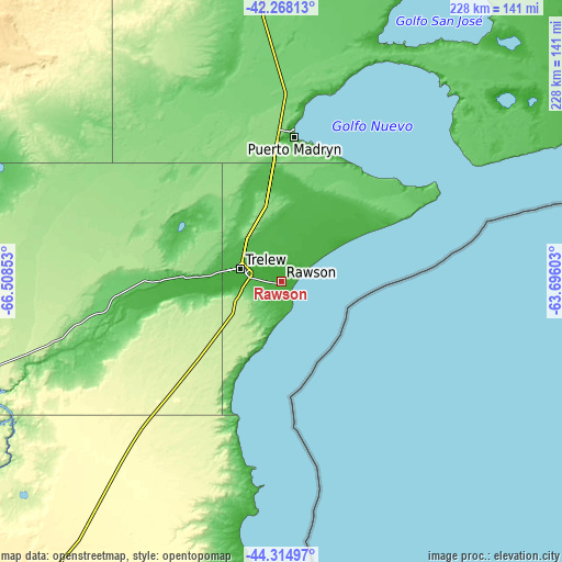
| \ | Map #1 | Map #2 | Topo.Map |
| Scale [m] | -3..23 m | -3..72 m | × |
| Scale [ft] | -10..75 ft | -10..236 ft | × |
| Average | 8.1 m = 27 ft | 13.5 m = 44 ft | × |
| Width | 7.11 km = 4.4 mi | 14.22 km = 8.8 mi | 227.6 km = 141.4 mi |
| Height | 7.11 km = 4.4 mi | 14.22 km = 8.8 mi | 227.6 km = 141.4 mi |
| ↑Max Latitude | -43.268169° | -43.236162° | -42.26813° |
| Latitude at center | -43.30016° | -43.30016° | -43.30016° |
| ↓Min Latitude | -43.332134° | -43.364091° | -44.31497° |
| ← Min Longitude | -65.146225° | -65.190171° | -66.50853° |
| Longitude center | -65.10228° | -65.10228° | -65.10228° |
| →Max Longitude | -65.058335° | -65.014389° | -63.69603° |
Nearby cities:
Cities around Rawson sort by population:
• Trelew elevation 14 m
17.4 km,  289°
289°
• Puerto Madryn 11 m
59.3 km,  5°
5°
• Viedma 8 m
326.6 km,  32°
32°
• San Antonio Oeste 12 m
285.8 km,  2°
2°
• Sierra Grande 245 m
189.5 km,  353°
353°
• Gaimán 21 m
31.6 km,  272°
272°
• Valcheta 185 m
304.2 km,  343°
343°
• Dolavón 16 m
48.9 km, 269°
• Camarones 32 m
173.4 km,  196°
196°
• Paso de Indios 472 m
323.7 km,  258°
258°
• Las Plumas 169 m
182 km, 255°
• Telsen 348 m
178 km,  302°
302°
Multilingual:
 En español:
Rawson elevación 13 m.
 En France:
Rawson élévation 13 m.


Sources and notes:
- [note 1] Map square and city borders are not equal. Map elevation data is calculated only from area inside that square.
- [src 1] Elevation data from geonames database provided with same terms of usage.
- [src 2] The elevation map of Rawson is generated using elevation data from NASA's 3 arcsec (90m) resolution SRTM data.
- [src 3] Base (background) map © OpenStreetMap contributors tiles are generated by Geofabrik and OpenTopoMap.
Copyright & License:
This Rawson Elevation Map is licensed under CC BY-SA. You may reuse any part from this page, if you give a proper credit by linking to this URL:
 More info on terms of use page.