Viedma elevation
Viedma (Rio Negro, Departamento de Adolfo Alsina), Argentina elevation is 8 meters and Viedma elevation in feet is 26 ft above sea level [src 1]. Viedma is a seat of a first-order administrative division (feature code) with elevation that is 342 meters (1122 ft) smaller than average city elevation in Argentina.
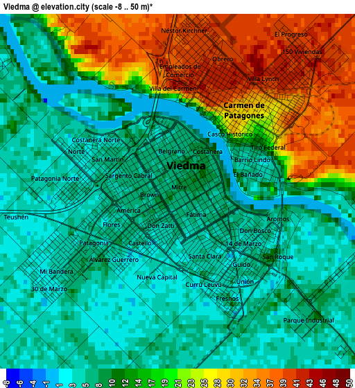
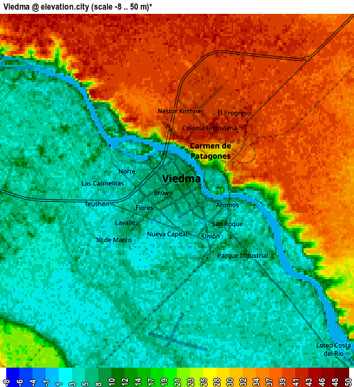
Below is the Elevation map of Viedma, which displays elevation range with different colors. Scale of the first map is from -8 to 50 m (-26 to 164 ft) with average elevation of 13.2 meters (=43 ft) [note 1]
These maps also provides idea of topography and contour of this city, they are displayed at different zoom levels. More info about maps, scale and edge coordinates you can find below images.
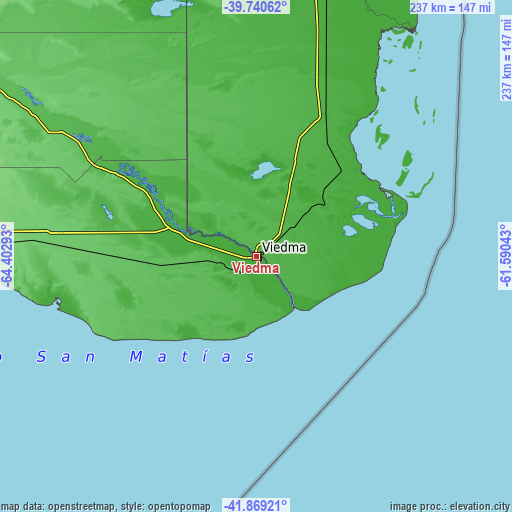
| \ | Map #1 | Map #2 | Topo.Map |
| Scale [m] | -8..50 m | -8..50 m | × |
| Scale [ft] | -26..164 ft | -26..164 ft | × |
| Average | 13.2 m = 43 ft | 18.4 m = 60 ft | × |
| Width | 7.4 km = 4.6 mi | 14.79 km = 9.2 mi | 236.7 km = 147.1 mi |
| Height | 7.4 km = 4.6 mi | 14.79 km = 9.2 mi | 236.7 km = 147.1 mi |
| ↑Max Latitude | -40.780182° | -40.746897° | -39.74062° |
| Latitude at center | -40.81345° | -40.81345° | -40.81345° |
| ↓Min Latitude | -40.846701° | -40.879936° | -41.86921° |
| ← Min Longitude | -63.040625° | -63.084571° | -64.40293° |
| Longitude center | -62.99668° | -62.99668° | -62.99668° |
| →Max Longitude | -62.952735° | -62.908789° | -61.59043° |
Nearby cities:
Cities around Viedma sort by population:
• Bahía Blanca elevation 24 m
240.9 km,  14°
14°
• Punta Alta 8 m
229.4 km,  20°
20°
• San Antonio Oeste 12 m
164.5 km,  273°
273°
• Coronel Dorrego 112 m
274.9 km,  32°
32°
• Sierra Grande 245 m
216.1 km,  245°
245°
• General Conesa 58 m
146.5 km,  302°
302°
• Valcheta 185 m
267.1 km, 273°
• La Adela 114 m
223.6 km,  335°
335°
• Monte Hermoso 13 m
250 km,  35°
35°
• Río Colorado 81 m
222.9 km, 335°
• Médanos 34 m
222.3 km, 6°
• Carmen de Patagones 31 m
2.1 km, 38°
Multilingual:
 En español:
Viedma elevación 8 m.
 En France:
Viedma élévation 8 m.


Sources and notes:
- [note 1] Map square and city borders are not equal. Map elevation data is calculated only from area inside that square.
- [src 1] Elevation data from geonames database provided with same terms of usage.
- [src 2] The elevation map of Viedma is generated using elevation data from NASA's 3 arcsec (90m) resolution SRTM data.
- [src 3] Base (background) map © OpenStreetMap contributors tiles are generated by Geofabrik and OpenTopoMap.
Copyright & License:
This Viedma Elevation Map is licensed under CC BY-SA. You may reuse any part from this page, if you give a proper credit by linking to this URL:
 More info on terms of use page.