Samuhú elevation
Samuhú (Chaco, Departamento de San Lorenzo), Argentina elevation is 75 meters and Samuhú elevation in feet is 246 ft above sea level [src 1]. Samuhú is a populated place (feature code) with elevation that is 275 meters (902 ft) smaller than average city elevation in Argentina.
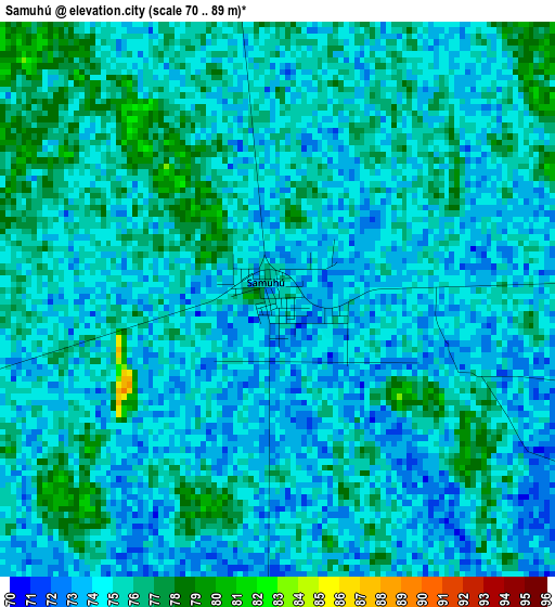
Below is the Elevation map of Samuhú, which displays elevation range with different colors. Scale of the first map is from 70 to 89 m (230 to 292 ft) with average elevation of 74.5 meters (=244 ft) [note 1]
These maps also provides idea of topography and contour of this city, they are displayed at different zoom levels. More info about maps, scale and edge coordinates you can find below images.
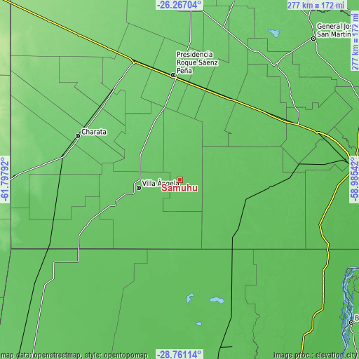
| \ | Map #1 | Topo.Map |
| Scale [m] | 70..89 m | × |
| Scale [ft] | 230..292 ft | × |
| Average | 74.5 m = 244 ft | × |
| Width | 8.67 km = 5.4 mi | 277.3 km = 172.3 mi |
| Height | 8.67 km = 5.4 mi | 277.3 km = 172.3 mi |
| ↑Max Latitude | -27.482181° | -26.26704° |
| Latitude at center | -27.52116° | -27.52116° |
| ↓Min Latitude | -27.560126° | -28.76114° |
| ← Min Longitude | -60.435615° | -61.79792° |
| Longitude center | -60.39167° | -60.39167° |
| →Max Longitude | -60.347725° | -58.98542° |
Nearby cities:
Cities around Samuhú sort by population:
• Villa Ángela elevation 79 m
32.4 km,  259°
259°
• Quitilipi 88 m
74.5 km,  13°
13°
• Machagai 90 m
74.3 km,  27°
27°
• Presidencia de la Plaza 76 m
79.3 km,  43°
43°
• Villa Berthet 83 m
25.6 km,  355°
355°
• San Bernardo 88 m
40.9 km,  309°
309°
• Coronel Du Graty 82 m
54.5 km,  251°
251°
• Santa Sylvina 77 m
81.2 km,  244°
244°
• La Tigra 93 m
49.6 km,  337°
337°
• La Clotilde 94 m
51 km,  327°
327°
• Charadai 67 m
54.2 km,  105°
105°
• Coté-Lai 65 m
78.1 km,  88°
88°
Multilingual:
 En español:
Samuhú elevación 75 m.
 En France:
Samuhú élévation 75 m.


Sources and notes:
- [note 1] Map square and city borders are not equal. Map elevation data is calculated only from area inside that square.
- [src 1] Elevation data from geonames database provided with same terms of usage.
- [src 2] The elevation map of Samuhú is generated using elevation data from NASA's 3 arcsec (90m) resolution SRTM data.
- [src 3] Base (background) map © OpenStreetMap contributors tiles are generated by Geofabrik and OpenTopoMap.
Copyright & License:
This Samuhú Elevation Map is licensed under CC BY-SA. You may reuse any part from this page, if you give a proper credit by linking to this URL:
 More info on terms of use page.