Tres Arroyos elevation
Tres Arroyos (Buenos Aires, Partido de Tres Arroyos), Argentina elevation is 113 meters and Tres Arroyos elevation in feet is 371 ft above sea level [src 1]. Tres Arroyos is a seat of a second-order administrative division (feature code) with elevation that is 237 meters (778 ft) smaller than average city elevation in Argentina.
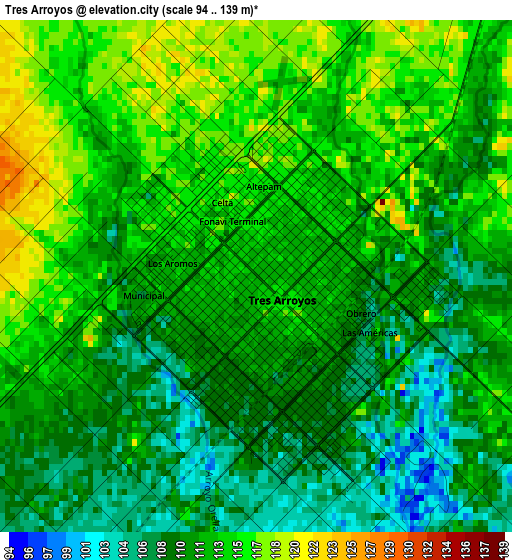
Below is the Elevation map of Tres Arroyos, which displays elevation range with different colors. Scale of the first map is from 94 to 139 m (308 to 456 ft) with average elevation of 111.9 meters (=367 ft) [note 1]
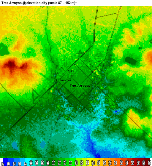
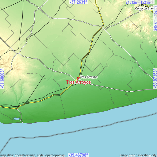
These maps also provides idea of topography and contour of this city, they are displayed at different zoom levels. More info about maps, scale and edge coordinates you can find below images.
| \ | Map #1 | Map #2 | Topo.Map |
| Scale [m] | 94..139 m | 87..152 m | × |
| Scale [ft] | 308..456 ft | 285..499 ft | × |
| Average | 111.9 m = 367 ft | 114.4 m = 375 ft | × |
| Width | 7.66 km = 4.8 mi | 15.32 km = 9.5 mi | 245.2 km = 152.4 mi |
| Height | 7.66 km = 4.8 mi | 15.32 km = 9.5 mi | 245.2 km = 152.4 mi |
| ↑Max Latitude | -38.33948° | -38.305003° | -37.2631° |
| Latitude at center | -38.37394° | -38.37394° | -38.37394° |
| ↓Min Latitude | -38.408384° | -38.442811° | -39.46798° |
| ← Min Longitude | -60.323725° | -60.367671° | -61.68603° |
| Longitude center | -60.27978° | -60.27978° | -60.27978° |
| →Max Longitude | -60.235835° | -60.191889° | -58.87353° |
Nearby cities:
Cities around Tres Arroyos sort by population:
• Tandil elevation 192 m
154.3 km,  40°
40°
• Olavarría 170 m
164.7 km,  358°
358°
• Necochea 19 m
135.6 km,  98°
98°
• Punta Alta 8 m
165.5 km,  250°
250°
• Coronel Dorrego 112 m
95.6 km, 246°
• General La Madrid 172 m
152.1 km,  325°
325°
• Lobería 82 m
132.2 km,  79°
79°
• Monte Hermoso 13 m
111.1 km,  232°
232°
• Coronel Pringles 254 m
103.6 km,  294°
294°
• Laprida 213 m
102.9 km, 333°
• Benito Juárez 219 m
88.4 km,  27°
27°
• San Cayetano 100 m
58.5 km,  87°
87°
Multilingual:
 En español:
Tres Arroyos elevación 113 m.
 En France:
Tres Arroyos élévation 113 m.
 Auf Deutsch:
Tres Arroyos höhe über dem Meeresspiegel ist 113 m.

Sources and notes:
- [note 1] Map square and city borders are not equal. Map elevation data is calculated only from area inside that square.
- [src 1] Elevation data from geonames database provided with same terms of usage.
- [src 2] The elevation map of Tres Arroyos is generated using elevation data from NASA's 3 arcsec (90m) resolution SRTM data.
- [src 3] Base (background) map © OpenStreetMap contributors tiles are generated by Geofabrik and OpenTopoMap.
Copyright & License:
This Tres Arroyos Elevation Map is licensed under CC BY-SA. You may reuse any part from this page, if you give a proper credit by linking to this URL:
 More info on terms of use page.