Tandil elevation
Tandil (Buenos Aires, Partido de Tandil), Argentina elevation is 192 meters and Tandil elevation in feet is 630 ft above sea level [src 1]. Tandil is a seat of a second-order administrative division (feature code) with elevation that is 158 meters (518 ft) smaller than average city elevation in Argentina.
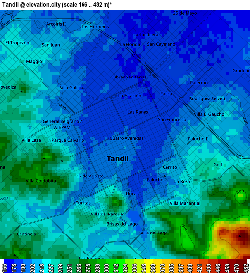
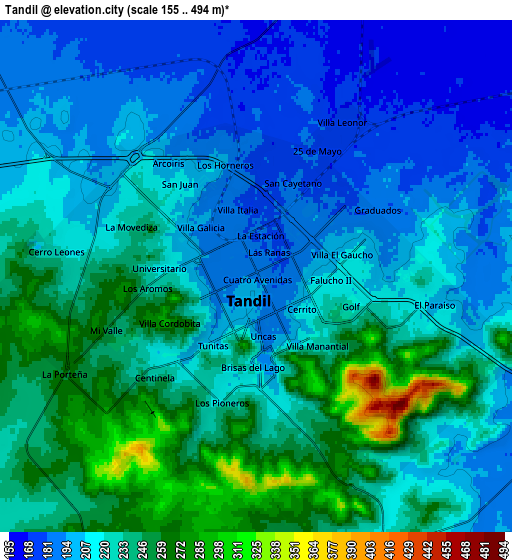
Below is the Elevation map of Tandil, which displays elevation range with different colors. Scale of the first map is from 166 to 482 m (545 to 1581 ft) with average elevation of 215.9 meters (=708 ft) [note 1]
These maps also provides idea of topography and contour of this city, they are displayed at different zoom levels. More info about maps, scale and edge coordinates you can find below images.
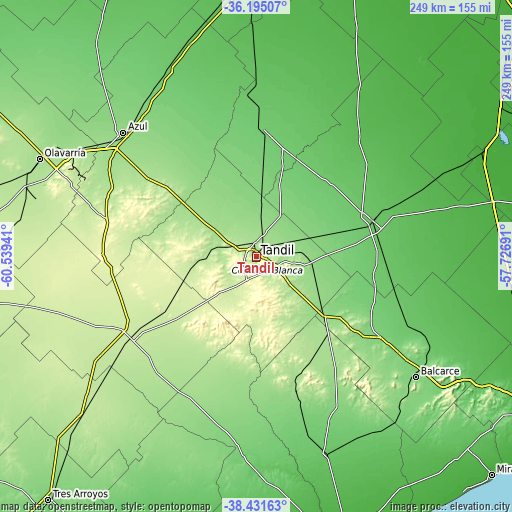
| \ | Map #1 | Map #2 | Topo.Map |
| Scale [m] | 166..482 m | 155..494 m | × |
| Scale [ft] | 545..1581 ft | 509..1621 ft | × |
| Average | 215.9 m = 708 ft | 220.9 m = 725 ft | × |
| Width | 7.77 km = 4.8 mi | 15.54 km = 9.7 mi | 248.7 km = 154.5 mi |
| Height | 7.77 km = 4.8 mi | 15.54 km = 9.7 mi | 248.7 km = 154.5 mi |
| ↑Max Latitude | -37.286715° | -37.251743° | -36.19507° |
| Latitude at center | -37.32167° | -37.32167° | -37.32167° |
| ↓Min Latitude | -37.356609° | -37.391532° | -38.43163° |
| ← Min Longitude | -59.177105° | -59.221051° | -60.53941° |
| Longitude center | -59.13316° | -59.13316° | -59.13316° |
| →Max Longitude | -59.089215° | -59.045269° | -57.72691° |
Nearby cities:
Cities around Tandil sort by population:
• Olavarría elevation 170 m
115.7 km,  294°
294°
• Azul 141 m
88.4 km,  313°
313°
• Balcarce 126 m
96.9 km,  127°
127°
• General Guido 14 m
141.2 km,  57°
57°
• Tapalqué 90 m
133.7 km,  323°
323°
• Coronel Vidal 26 m
124.9 km,  96°
96°
• Maipú 16 m
122.2 km,  65°
65°
• San Cayetano 100 m
121.4 km,  200°
200°
• Lobería 82 m
97.5 km,  162°
162°
• Benito Juárez 219 m
71 km,  236°
236°
• Rauch 95 m
61 km,  3°
3°
• Ayacucho 81 m
60.2 km, 71°
Multilingual:
 En español:
Tandil elevación 192 m.
 En France:
Tandil élévation 192 m.


Sources and notes:
- [note 1] Map square and city borders are not equal. Map elevation data is calculated only from area inside that square.
- [src 1] Elevation data from geonames database provided with same terms of usage.
- [src 2] The elevation map of Tandil is generated using elevation data from NASA's 3 arcsec (90m) resolution SRTM data.
- [src 3] Base (background) map © OpenStreetMap contributors tiles are generated by Geofabrik and OpenTopoMap.
Copyright & License:
This Tandil Elevation Map is licensed under CC BY-SA. You may reuse any part from this page, if you give a proper credit by linking to this URL:
 More info on terms of use page.