Gualeguay elevation
Gualeguay (Entre Rios, Departamento de Gualeguay), Argentina elevation is 14 meters and Gualeguay elevation in feet is 46 ft above sea level [src 1]. Gualeguay is a seat of a second-order administrative division (feature code) with elevation that is 336 meters (1102 ft) smaller than average city elevation in Argentina.
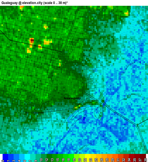
Below is the Elevation map of Gualeguay, which displays elevation range with different colors. Scale of the first map is from 0 to 38 m (0 to 125 ft) with average elevation of 10.4 meters (=34 ft) [note 1]
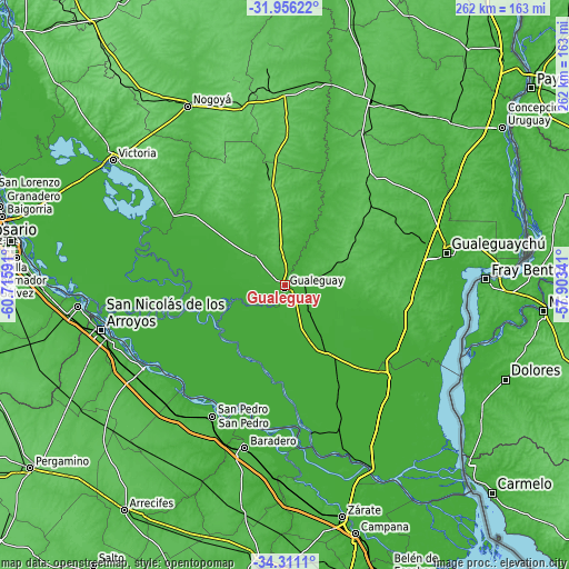
These maps also provides idea of topography and contour of this city, they are displayed at different zoom levels. More info about maps, scale and edge coordinates you can find below images.
| \ | Map #1 | Map #2 | Topo.Map |
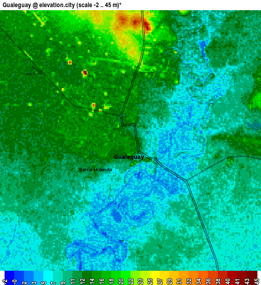
| Scale [m] | 0..38 m | -2..45 m | × |
| Scale [ft] | 0..125 ft | -7..148 ft | × |
| Average | 10.4 m = 34 ft | 11 m = 36 ft | × |
| Width | 8.18 km = 5.1 mi | 16.37 km = 10.2 mi | 261.8 km = 162.7 mi |
| Height | 8.18 km = 5.1 mi | 16.37 km = 10.2 mi | 261.8 km = 162.7 mi |
| ↑Max Latitude | -33.104756° | -33.067936° | -31.95622° |
| Latitude at center | -33.14156° | -33.14156° | -33.14156° |
| ↓Min Latitude | -33.178349° | -33.215122° | -34.3111° |
| ← Min Longitude | -59.353605° | -59.397551° | -60.71591° |
| Longitude center | -59.30966° | -59.30966° | -59.30966° |
| →Max Longitude | -59.265715° | -59.221769° | -57.90341° |
Nearby cities:
Cities around Gualeguay sort by population:
• San Nicolás de los Arroyos elevation 28 m
86.5 km,  255°
255°
• Gualeguaychú 14 m
75.3 km,  78°
78°
• San Pedro 30 m
68.3 km,  208°
208°
• Urdinarrain 68 m
63.9 km,  37°
37°
• Larroque 54 m
31 km,  67°
67°
• Puerto Ibicuy 4 m
69.1 km,  169°
169°
• General Galarza 54 m
47.5 km,  350°
350°
• Gobernador Mansilla 50 m
66.5 km,  356°
356°
• Ceibas 7 m
61.3 km,  121°
121°
• Aldea San Antonio 39 m
80.7 km, 44°
• Baradero 29 m
76.7 km,  193°
193°
• Ramallo 23 m
75.2 km,  239°
239°
Multilingual:
 En español:
Gualeguay elevación 14 m.
 En France:
Gualeguay élévation 14 m.
 Auf Deutsch:
Gualeguay höhe über dem Meeresspiegel ist 14 m.

Sources and notes:
- [note 1] Map square and city borders are not equal. Map elevation data is calculated only from area inside that square.
- [src 1] Elevation data from geonames database provided with same terms of usage.
- [src 2] The elevation map of Gualeguay is generated using elevation data from NASA's 3 arcsec (90m) resolution SRTM data.
- [src 3] Base (background) map © OpenStreetMap contributors tiles are generated by Geofabrik and OpenTopoMap.
Copyright & License:
This Gualeguay Elevation Map is licensed under CC BY-SA. You may reuse any part from this page, if you give a proper credit by linking to this URL:
 More info on terms of use page.