Mburucuyá elevation
Mburucuyá (Corrientes, Departamento de Mburucuyá), Argentina elevation is 79 meters and Mburucuyá elevation in feet is 259 ft above sea level [src 1]. Mburucuyá is a seat of a second-order administrative division (feature code) with elevation that is 271 meters (889 ft) smaller than average city elevation in Argentina.
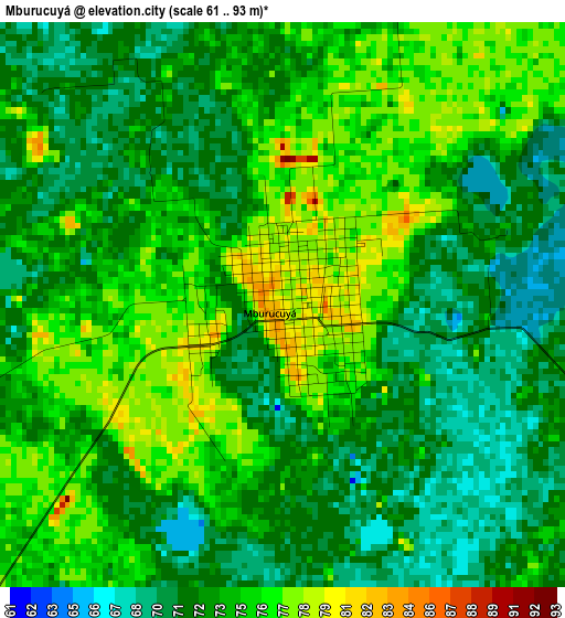
Below is the Elevation map of Mburucuyá, which displays elevation range with different colors. Scale of the first map is from 61 to 93 m (200 to 305 ft) with average elevation of 73.3 meters (=240 ft) [note 1]
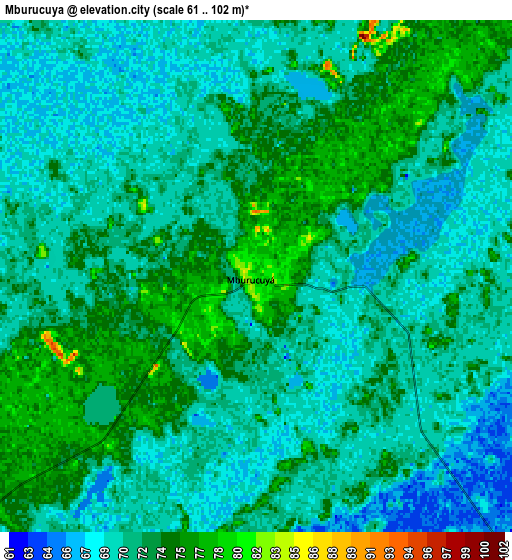
These maps also provides idea of topography and contour of this city, they are displayed at different zoom levels. More info about maps, scale and edge coordinates you can find below images.
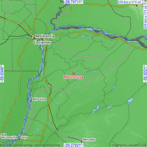
| \ | Map #1 | Map #2 | Topo.Map |
| Scale [m] | 61..93 m | 61..102 m | × |
| Scale [ft] | 200..305 ft | 200..335 ft | × |
| Average | 73.3 m = 240 ft | 71.5 m = 235 ft | × |
| Width | 8.62 km = 5.4 mi | 17.25 km = 10.7 mi | 276 km = 171.5 mi |
| Height | 8.62 km = 5.4 mi | 17.25 km = 10.7 mi | 276 km = 171.5 mi |
| ↑Max Latitude | -28.006528° | -27.967722° | -26.79711° |
| Latitude at center | -28.04532° | -28.04532° | -28.04532° |
| ↓Min Latitude | -28.084098° | -28.122862° | -29.27921° |
| ← Min Longitude | -58.272295° | -58.316241° | -59.6346° |
| Longitude center | -58.22835° | -58.22835° | -58.22835° |
| →Max Longitude | -58.184405° | -58.140459° | -56.8221° |
Nearby cities:
Cities around Mburucuyá sort by population:
• San Lorenzo elevation 64 m
53.8 km,  259°
259°
• Saladas 75 m
45.4 km,  239°
239°
• San Luis del Palmar 62 m
67.8 km,  331°
331°
• Santa Rosa 79 m
26.5 km,  156°
156°
• Nuestra Señora del Rosario de Caa Catí 77 m
68.1 km,  61°
61°
• San Miguel 80 m
62.9 km,  84°
84°
• Concepción 67 m
51 km,  139°
139°
• Riachuelo 57 m
72.4 km,  315°
315°
• Palmar Grande 75 m
34.2 km,  70°
70°
• Lomas de Vallejos 71 m
46 km,  41°
41°
• Herlitzka 66 m
53.5 km,  357°
357°
• Empedrado 68 m
57.6 km,  280°
280°
Multilingual:
 En español:
Mburucuyá elevación 79 m.
 En France:
Mburucuyá élévation 79 m.
 Auf Deutsch:
Mburucuyá höhe über dem Meeresspiegel ist 79 m.

Sources and notes:
- [note 1] Map square and city borders are not equal. Map elevation data is calculated only from area inside that square.
- [src 1] Elevation data from geonames database provided with same terms of usage.
- [src 2] The elevation map of Mburucuyá is generated using elevation data from NASA's 3 arcsec (90m) resolution SRTM data.
- [src 3] Base (background) map © OpenStreetMap contributors tiles are generated by Geofabrik and OpenTopoMap.
Copyright & License:
This Mburucuyá Elevation Map is licensed under CC BY-SA. You may reuse any part from this page, if you give a proper credit by linking to this URL:
 More info on terms of use page.