San Luis del Palmar elevation
San Luis del Palmar (Corrientes, Departamento de San Luis del Palmar), Argentina elevation is 62 meters and San Luis del Palmar elevation in feet is 203 ft above sea level [src 1]. San Luis del Palmar is a seat of a second-order administrative division (feature code) with elevation that is 288 meters (945 ft) smaller than average city elevation in Argentina.
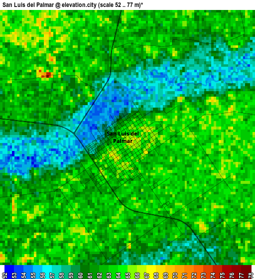
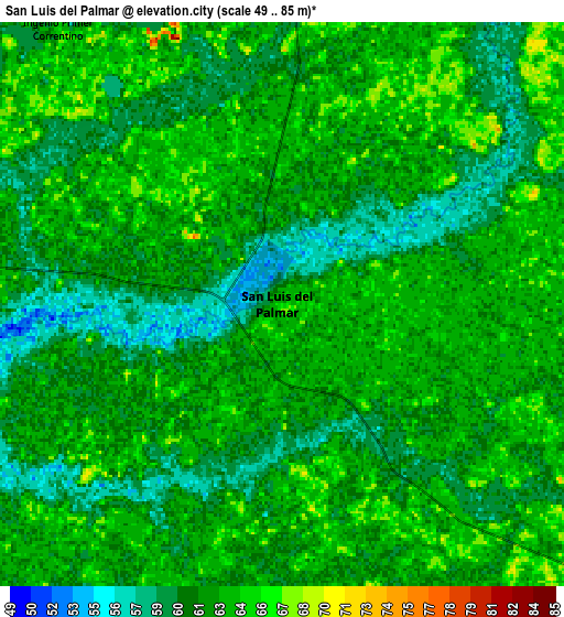
Below is the Elevation map of San Luis del Palmar, which displays elevation range with different colors. Scale of the first map is from 52 to 77 m (171 to 253 ft) with average elevation of 61.4 meters (=201 ft) [note 1]
These maps also provides idea of topography and contour of this city, they are displayed at different zoom levels. More info about maps, scale and edge coordinates you can find below images.
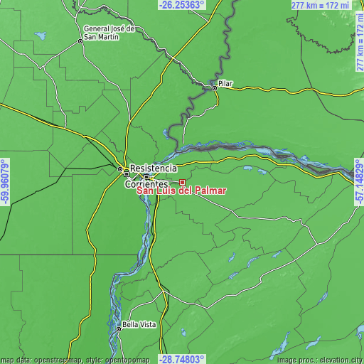
| \ | Map #1 | Map #2 | Topo.Map |
| Scale [m] | 52..77 m | 49..85 m | × |
| Scale [ft] | 171..253 ft | 161..279 ft | × |
| Average | 61.4 m = 201 ft | 62 m = 203 ft | × |
| Width | 8.67 km = 5.4 mi | 17.34 km = 10.8 mi | 277.4 km = 172.4 mi |
| Height | 8.67 km = 5.4 mi | 17.34 km = 10.8 mi | 277.4 km = 172.4 mi |
| ↑Max Latitude | -27.468916° | -27.429918° | -26.25363° |
| Latitude at center | -27.5079° | -27.5079° | -27.5079° |
| ↓Min Latitude | -27.54687° | -27.585827° | -28.74803° |
| ← Min Longitude | -58.598485° | -58.642431° | -59.96079° |
| Longitude center | -58.55454° | -58.55454° | -58.55454° |
| →Max Longitude | -58.510595° | -58.466649° | -57.14829° |
Nearby cities:
Cities around San Luis del Palmar sort by population:
• Resistencia elevation 56 m
42.7 km,  277°
277°
• Corrientes 53 m
28 km, 279°
• Barranqueras 52 m
38.1 km,  274°
274°
• Fontana 54 m
47.4 km, 282°
• Puerto Vilelas 52 m
37.9 km, 268°
• Itatí 65 m
40.4 km,  49°
49°
• Paso de la Patria 56 m
21.3 km,  355°
355°
• Margarita Belén 58 m
49.5 km,  303°
303°
• San Cosme 72 m
15.8 km,  15°
15°
• Riachuelo 57 m
20.5 km,  246°
246°
• Colonia Benítez 54 m
43.4 km, 296°
• Herlitzka 66 m
30.2 km,  102°
102°
Multilingual:
 En español:
San Luis del Palmar elevación 62 m.
 En France:
San Luis del Palmar élévation 62 m.
 Auf Deutsch:
San Luis del Palmar höhe über dem Meeresspiegel ist 62 m.
 На русском:
San Luis del Palmar высота над уровнем моря 62 м
Sources and notes:
- [note 1] Map square and city borders are not equal. Map elevation data is calculated only from area inside that square.
- [src 1] Elevation data from geonames database provided with same terms of usage.
- [src 2] The elevation map of San Luis del Palmar is generated using elevation data from NASA's 3 arcsec (90m) resolution SRTM data.
- [src 3] Base (background) map © OpenStreetMap contributors tiles are generated by Geofabrik and OpenTopoMap.
Copyright & License:
This San Luis del Palmar Elevation Map is licensed under CC BY-SA. You may reuse any part from this page, if you give a proper credit by linking to this URL:
 More info on terms of use page.