Saladas elevation
Saladas (Corrientes, Departamento de Saladas), Argentina elevation is 75 meters and Saladas elevation in feet is 246 ft above sea level [src 1]. Saladas is a seat of a second-order administrative division (feature code) with elevation that is 275 meters (902 ft) smaller than average city elevation in Argentina.
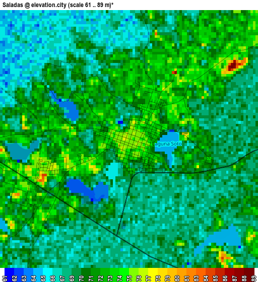
Below is the Elevation map of Saladas, which displays elevation range with different colors. Scale of the first map is from 61 to 89 m (200 to 292 ft) with average elevation of 69.6 meters (=228 ft) [note 1]
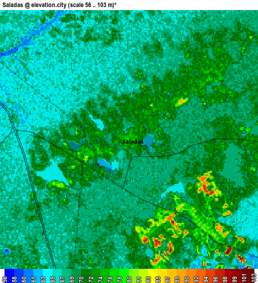
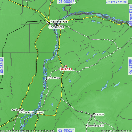
These maps also provides idea of topography and contour of this city, they are displayed at different zoom levels. More info about maps, scale and edge coordinates you can find below images.
| \ | Map #1 | Map #2 | Topo.Map |
| Scale [m] | 61..89 m | 56..103 m | × |
| Scale [ft] | 200..292 ft | 184..338 ft | × |
| Average | 69.6 m = 228 ft | 69 m = 226 ft | × |
| Width | 8.61 km = 5.3 mi | 17.22 km = 10.7 mi | 275.4 km = 171.1 mi |
| Height | 8.61 km = 5.3 mi | 17.22 km = 10.7 mi | 275.5 km = 171.2 mi |
| ↑Max Latitude | -28.215123° | -28.176393° | -27.00801° |
| Latitude at center | -28.25384° | -28.25384° | -28.25384° |
| ↓Min Latitude | -28.292543° | -28.331231° | -29.48528° |
| ← Min Longitude | -58.669855° | -58.713801° | -60.03216° |
| Longitude center | -58.62591° | -58.62591° | -58.62591° |
| →Max Longitude | -58.581965° | -58.538019° | -57.21966° |
Nearby cities:
Cities around Saladas sort by population:
• San Lorenzo elevation 64 m
19.3 km,  314°
314°
• Las Toscas 53 m
62.8 km,  259°
259°
• Mburucuyá 79 m
45.4 km,  59°
59°
• Santa Rosa 79 m
49.7 km,  91°
91°
• Concepción 67 m
73.9 km,  101°
101°
• Tacuarendí 50 m
64.5 km,  254°
254°
• Nueve de Julio 74 m
68.1 km,  196°
196°
• Pedro R. Fernández 73 m
55.4 km,  183°
183°
• Cruz de los Milagros 59 m
74.6 km,  209°
209°
• Bella Vista 63 m
49.5 km,  235°
235°
• Empedrado 68 m
37.9 km,  332°
332°
• San Roque 64 m
36.6 km,  192°
192°
Multilingual:
 En español:
Saladas elevación 75 m.
 En France:
Saladas élévation 75 m.


Sources and notes:
- [note 1] Map square and city borders are not equal. Map elevation data is calculated only from area inside that square.
- [src 1] Elevation data from geonames database provided with same terms of usage.
- [src 2] The elevation map of Saladas is generated using elevation data from NASA's 3 arcsec (90m) resolution SRTM data.
- [src 3] Base (background) map © OpenStreetMap contributors tiles are generated by Geofabrik and OpenTopoMap.
Copyright & License:
This Saladas Elevation Map is licensed under CC BY-SA. You may reuse any part from this page, if you give a proper credit by linking to this URL:
 More info on terms of use page.