Zárate elevation
Zárate (Buenos Aires, Partido de Zárate), Argentina elevation is 28 meters and Zárate elevation in feet is 92 ft above sea level [src 1]. Zárate is a seat of a second-order administrative division (feature code) with elevation that is 322 meters (1056 ft) smaller than average city elevation in Argentina.
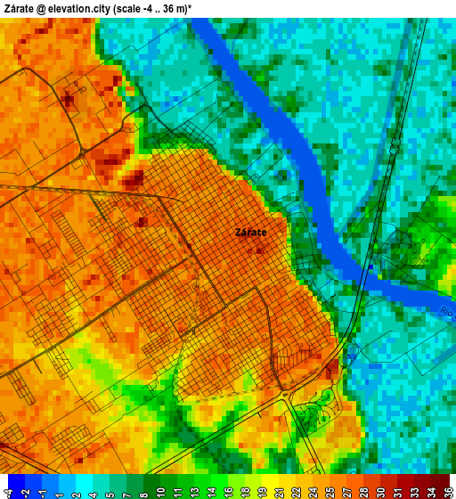
Below is the Elevation map of Zárate, which displays elevation range with different colors. Scale of the first map is from -4 to 36 m (-13 to 118 ft) with average elevation of 15.6 meters (=51 ft) [note 1]
These maps also provides idea of topography and contour of this city, they are displayed at different zoom levels. More info about maps, scale and edge coordinates you can find below images.
| \ | Map #1 | Map #2 | Topo.Map |
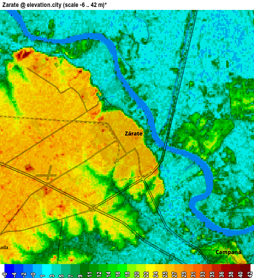
| Scale [m] | -4..36 m | -6..42 m | × |
| Scale [ft] | -13..118 ft | -20..138 ft | × |
| Average | 15.6 m = 51 ft | 12.6 m = 41 ft | × |
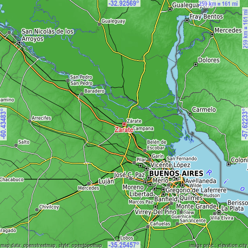
| Width | 8.09 km = 5 mi | 16.18 km = 10.1 mi | 258.9 km = 160.9 mi |
| Height | 8.09 km = 5 mi | 16.18 km = 10.1 mi | 258.9 km = 160.9 mi |
| ↑Max Latitude | -34.061742° | -34.025328° | -32.92569° |
| Latitude at center | -34.09814° | -34.09814° | -34.09814° |
| ↓Min Latitude | -34.134522° | -34.170889° | -35.25457° |
| ← Min Longitude | -59.072525° | -59.116471° | -60.43483° |
| Longitude center | -59.02858° | -59.02858° | -59.02858° |
| →Max Longitude | -58.984635° | -58.940689° | -57.62233° |
Nearby cities:
Cities around Zárate sort by population:
• José C. Paz elevation 24 m
52.2 km,  152°
152°
• Pilar 27 m
41.4 km,  165°
165°
• Luján 27 m
53 km,  187°
187°
• Campana 16 m
9.7 km,  138°
138°
• General Pacheco 4 m
53 km, 138°
• Tortuguitas 20 m
48.9 km, 148°
• Ingeniero Pablo Nogués 15 m
51.5 km, 144°
• Puerto Ibicuy 4 m
40.8 km,  340°
340°
• Santa Catalina - Dique Lujan -2 m
43.4 km, 137°
• San Antonio de Areco 32 m
44.1 km,  247°
247°
• Belén de Escobar 26 m
35.3 km, 142°
• Capilla del Señor 24 m
22.6 km,  197°
197°
Multilingual:
 En español:
Zárate elevación 28 m.
 En France:
Zárate élévation 28 m.


Sources and notes:
- [note 1] Map square and city borders are not equal. Map elevation data is calculated only from area inside that square.
- [src 1] Elevation data from geonames database provided with same terms of usage.
- [src 2] The elevation map of Zárate is generated using elevation data from NASA's 3 arcsec (90m) resolution SRTM data.
- [src 3] Base (background) map © OpenStreetMap contributors tiles are generated by Geofabrik and OpenTopoMap.
Copyright & License:
This Zárate Elevation Map is licensed under CC BY-SA. You may reuse any part from this page, if you give a proper credit by linking to this URL:
 More info on terms of use page.