Luján elevation
Luján (Buenos Aires, Partido de Luján), Argentina elevation is 27 meters and Luján elevation in feet is 89 ft above sea level [src 1]. Luján is a seat of a second-order administrative division (feature code) with elevation that is 323 meters (1060 ft) smaller than average city elevation in Argentina.
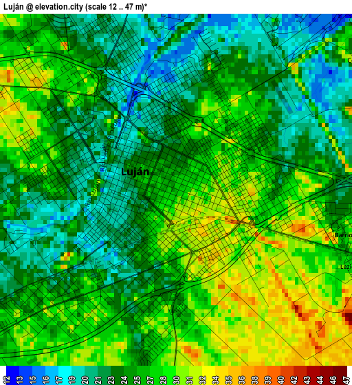
Below is the Elevation map of Luján, which displays elevation range with different colors. Scale of the first map is from 12 to 47 m (39 to 154 ft) with average elevation of 25.7 meters (=84 ft) [note 1]
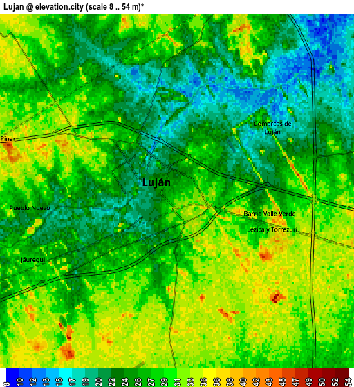
These maps also provides idea of topography and contour of this city, they are displayed at different zoom levels. More info about maps, scale and edge coordinates you can find below images.
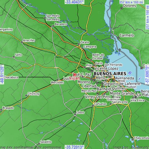
| \ | Map #1 | Map #2 | Topo.Map |
| Scale [m] | 12..47 m | 8..54 m | × |
| Scale [ft] | 39..154 ft | 26..177 ft | × |
| Average | 25.7 m = 84 ft | 27.3 m = 90 ft | × |
| Width | 8.05 km = 5 mi | 16.09 km = 10 mi | 257.5 km = 160 mi |
| Height | 8.05 km = 5 mi | 16.09 km = 10 mi | 257.5 km = 160 mi |
| ↑Max Latitude | -34.534086° | -34.497877° | -33.40431° |
| Latitude at center | -34.57028° | -34.57028° | -34.57028° |
| ↓Min Latitude | -34.606458° | -34.64262° | -35.72013° |
| ← Min Longitude | -59.148945° | -59.192891° | -60.51125° |
| Longitude center | -59.105° | -59.105° | -59.105° |
| →Max Longitude | -59.061055° | -59.017109° | -57.69875° |
Nearby cities:
Cities around Luján sort by population:
• Merlo elevation 21 m
36 km,  107°
107°
• José C. Paz 24 m
31.5 km,  78°
78°
• Pilar 27 m
21.4 km,  54°
54°
• San Miguel 30 m
36.1 km,  85°
85°
• Los Polvorines 28 m
37.3 km, 78°
• Mercedes 43 m
31.1 km,  253°
253°
• Tortuguitas 20 m
33.9 km,  71°
71°
• Muñiz 31 m
36.4 km, 87°
• San Andrés de Giles 51 m
34 km,  293°
293°
• Marcos Paz 28 m
34 km,  133°
133°
• Capilla del Señor 24 m
30.9 km,  0°
0°
• General Rodríguez 34 m
14.6 km, 106°
Multilingual:
 En español:
Luján elevación 27 m.
 En France:
Luján élévation 27 m.


Sources and notes:
- [note 1] Map square and city borders are not equal. Map elevation data is calculated only from area inside that square.
- [src 1] Elevation data from geonames database provided with same terms of usage.
- [src 2] The elevation map of Luján is generated using elevation data from NASA's 3 arcsec (90m) resolution SRTM data.
- [src 3] Base (background) map © OpenStreetMap contributors tiles are generated by Geofabrik and OpenTopoMap.
Copyright & License:
This Luján Elevation Map is licensed under CC BY-SA. You may reuse any part from this page, if you give a proper credit by linking to this URL:
 More info on terms of use page.