Kasakh elevation
Kasakh (Aragatsotn), Armenia elevation is 1857 meters and Kasakh elevation in feet is 6093 ft above sea level [src 1]. Kasakh is a populated place (feature code) with elevation that is 559 meters (1834 ft) bigger than average city elevation in Armenia.
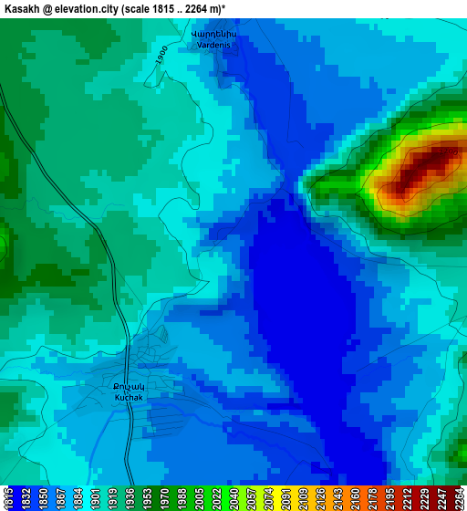
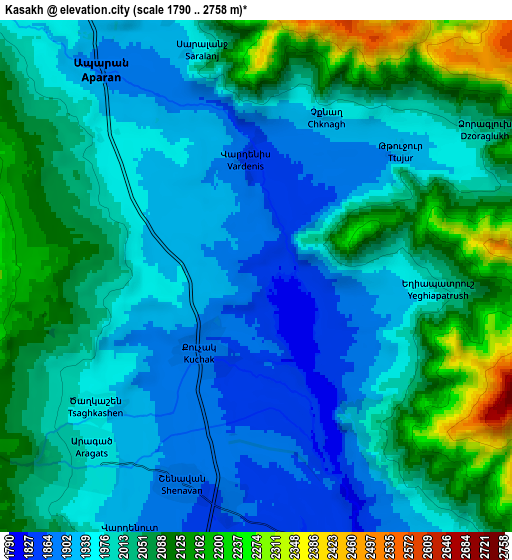
Below is the Elevation map of Kasakh, which displays elevation range with different colors. Scale of the first map is from 1815 to 2264 m (5955 to 7428 ft) with average elevation of 1895.5 meters (=6219 ft) [note 1]
These maps also provides idea of topography and contour of this city, they are displayed at different zoom levels. More info about maps, scale and edge coordinates you can find below images.
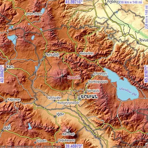
| \ | Map #1 | Map #2 | Topo.Map |
| Scale [m] | 1815..2264 m | 1790..2758 m | × |
| Scale [ft] | 5955..7428 ft | 5873..9049 ft | × |
| Average | 1895.5 m = 6219 ft | 2008.8 m = 6591 ft | × |
| Width | 7.43 km = 4.6 mi | 14.85 km = 9.2 mi | 237.7 km = 147.7 mi |
| Height | 7.43 km = 4.6 mi | 14.85 km = 9.2 mi | 237.7 km = 147.7 mi |
| ↑Max Latitude | 40.57036° | 40.603732° | 41.59716° |
| Latitude at center | 40.53697° | 40.53697° | 40.53697° |
| ↓Min Latitude | 40.503564° | 40.470141° | 39.45973° |
| ← Min Longitude | 44.366515° | 44.322569° | 43.00421° |
| Longitude center | 44.41046° | 44.41046° | 44.41046° |
| →Max Longitude | 44.454405° | 44.498351° | 45.81671° |
Nearby cities:
Cities around Kasakh sort by population:
• Aparan elevation 1892 m
7.6 km,  325°
325°
• Zovuni 1856 m
3.7 km,  140°
140°
• Karbi 1305 m
23.1 km,  186°
186°
• Bjni 1490 m
22.1 km,  113°
113°
• Aragats 1976 m
7.2 km,  222°
222°
• Arzakan 1483 m
19.3 km,  120°
120°
• Meghradzor 1785 m
21.8 km,  69°
69°
• Buzhakan 1845 m
12.9 km,  134°
134°
• Shenavan 1881 m
6.4 km,  200°
200°
• Tsaghkahovit 2108 m
19.2 km,  304°
304°
• Ushi 1394 m
21.3 km, 188°
• Zoravan 1469 m
22.3 km,  154°
154°
Multilingual:
 En español:
Kasakh elevación 1857 m.
 En France:
Kasakh élévation 1857 m.


Sources and notes:
- [note 1] Map square and city borders are not equal. Map elevation data is calculated only from area inside that square.
- [src 1] Elevation data from geonames database provided with same terms of usage.
- [src 2] The elevation map of Kasakh is generated using elevation data from NASA's 3 arcsec (90m) resolution SRTM data.
- [src 3] Base (background) map © OpenStreetMap contributors tiles are generated by Geofabrik and OpenTopoMap.
Copyright & License:
This Kasakh Elevation Map is licensed under CC BY-SA. You may reuse any part from this page, if you give a proper credit by linking to this URL:
 More info on terms of use page.