Arzakan elevation
Arzakan (Kotayk), Armenia elevation is 1483 meters and Arzakan elevation in feet is 4865 ft above sea level [src 1]. Arzakan is a populated place (feature code) with elevation that is 185 meters (607 ft) bigger than average city elevation in Armenia.
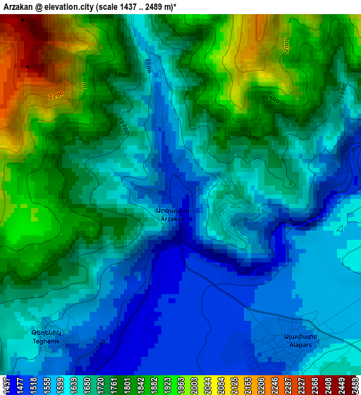
Below is the Elevation map of Arzakan, which displays elevation range with different colors. Scale of the first map is from 1437 to 2489 m (4715 to 8166 ft) with average elevation of 1712.4 meters (=5618 ft) [note 1]
These maps also provides idea of topography and contour of this city, they are displayed at different zoom levels. More info about maps, scale and edge coordinates you can find below images.
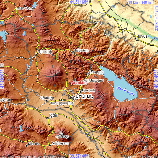
| \ | Map #1 | Topo.Map |
| Scale [m] | 1437..2489 m | × |
| Scale [ft] | 4715..8166 ft | × |
| Average | 1712.4 m = 5618 ft | × |
| Width | 7.44 km = 4.6 mi | 238 km = 147.9 mi |
| Height | 7.44 km = 4.6 mi | 238 km = 147.9 mi |
| ↑Max Latitude | 40.483503° | 41.51165° |
| Latitude at center | 40.45007° | 40.45007° |
| ↓Min Latitude | 40.416621° | 39.37145° |
| ← Min Longitude | 44.564335° | 43.20203° |
| Longitude center | 44.60828° | 44.60828° |
| →Max Longitude | 44.652225° | 46.01453° |
Nearby cities:
Cities around Arzakan sort by population:
• Hrazdan elevation 1762 m
14.4 km,  68°
68°
• Byureghavan 1385 m
15.2 km,  184°
184°
• Nor Geghi 1313 m
14.4 km,  188°
188°
• Bjni 1490 m
3.7 km,  75°
75°
• Argel 1430 m
8.1 km, 184°
• Lerrnanist 1922 m
15.7 km, 83°
• Solak 1658 m
8.5 km, 80°
• Buzhakan 1845 m
7.5 km,  274°
274°
• Tsaghkadzor 1861 m
13.2 km,  45°
45°
• Kaputan 1765 m
15.9 km,  150°
150°
• Zoravan 1469 m
12.8 km,  214°
214°
• Fantan 1801 m
9 km,  133°
133°
Multilingual:
 En español:
Arzakan elevación 1483 m.
 En France:
Arzakan élévation 1483 m.
 Auf Deutsch:
Arzakan höhe über dem Meeresspiegel ist 1483 m.

Sources and notes:
- [note 1] Map square and city borders are not equal. Map elevation data is calculated only from area inside that square.
- [src 1] Elevation data from geonames database provided with same terms of usage.
- [src 2] The elevation map of Arzakan is generated using elevation data from NASA's 3 arcsec (90m) resolution SRTM data.
- [src 3] Base (background) map © OpenStreetMap contributors tiles are generated by Geofabrik and OpenTopoMap.
Copyright & License:
This Arzakan Elevation Map is licensed under CC BY-SA. You may reuse any part from this page, if you give a proper credit by linking to this URL:
 More info on terms of use page.