Fushë-Lurë elevation
Fushë-Lurë (Dibër, Rrethi i Dibrës), Albania elevation is 1065 meters and Fushë-Lurë elevation in feet is 3494 ft above sea level [src 1]. Fushë-Lurë is a seat of a third-order administrative division (feature code) with elevation that is 691 meters (2267 ft) bigger than average city elevation in Albania.
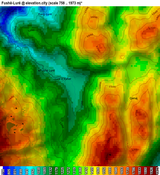
Below is the Elevation map of Fushë-Lurë, which displays elevation range with different colors. Scale of the first map is from 758 to 1973 m (2487 to 6473 ft) with average elevation of 1399.6 meters (=4592 ft) [note 1]
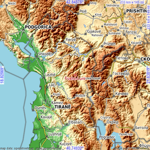
These maps also provides idea of topography and contour of this city, they are displayed at different zoom levels. More info about maps, scale and edge coordinates you can find below images.
| \ | Map #1 | Topo.Map |
| Scale [m] | 758..1973 m | × |
| Scale [ft] | 2487..6473 ft | × |
| Average | 1399.6 m = 4592 ft | × |
| Width | 7.28 km = 4.5 mi | 233.1 km = 144.8 mi |
| Height | 7.28 km = 4.5 mi | 233.1 km = 144.8 mi |
| ↑Max Latitude | 41.838859° | 42.84575° |
| Latitude at center | 41.80611° | 41.80611° |
| ↓Min Latitude | 41.773345° | 40.74932° |
| ← Min Longitude | 20.187995° | 18.82569° |
| Longitude center | 20.23194° | 20.23194° |
| →Max Longitude | 20.275885° | 21.63819° |
Nearby cities:
Cities around Fushë-Lurë sort by population:
• Kurbnesh elevation 745 m
12.6 km,  256°
256°
• Ujmisht 594 m
14.8 km,  39°
39°
• Sllovë 914 m
14.6 km,  92°
92°
• Kthella e Epërme 600 m
14.4 km,  272°
272°
• Shëngjin 916 m
13.8 km,  344°
344°
• Arrën 1054 m
12.8 km,  21°
21°
• Orosh 746 m
12.7 km,  283°
283°
• Kalis 762 m
11.7 km,  71°
71°
• Arras 417 m
10.9 km,  135°
135°
• Zall-Reç 488 m
10.7 km, 43°
• Fushë-Çidhnë 401 m
10.4 km,  119°
119°
• Zall-Dardhë 397 m
8.6 km, 89°
Multilingual:
 En español:
Fushë-Lurë elevación 1065 m.
 En France:
Fushë-Lurë élévation 1065 m.
 Auf Deutsch:
Fushë-Lurë höhe über dem Meeresspiegel ist 1065 m.

Sources and notes:
- [note 1] Map square and city borders are not equal. Map elevation data is calculated only from area inside that square.
- [src 1] Elevation data from geonames database provided with same terms of usage.
- [src 2] The elevation map of Fushë-Lurë is generated using elevation data from NASA's 3 arcsec (90m) resolution SRTM data.
- [src 3] Base (background) map © OpenStreetMap contributors tiles are generated by Geofabrik and OpenTopoMap.
Copyright & License:
This Fushë-Lurë Elevation Map is licensed under CC BY-SA. You may reuse any part from this page, if you give a proper credit by linking to this URL:
 More info on terms of use page.