Kurbnesh elevation
Kurbnesh (Lezhë), Albania elevation is 745 meters and Kurbnesh elevation in feet is 2444 ft above sea level [src 1]. Kurbnesh is a populated place (feature code) with elevation that is 371 meters (1217 ft) bigger than average city elevation in Albania.
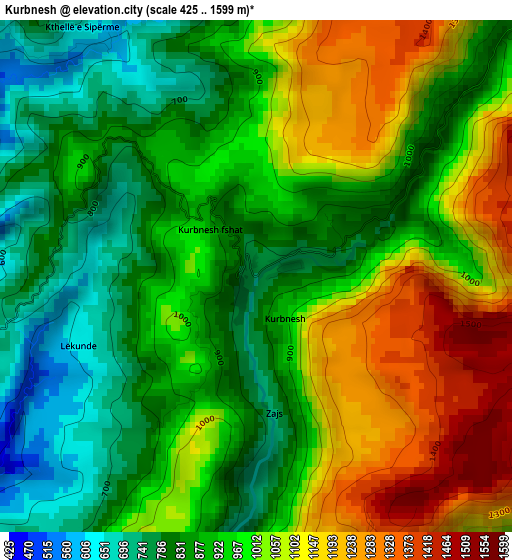
Below is the Elevation map of Kurbnesh, which displays elevation range with different colors. Scale of the first map is from 425 to 1599 m (1394 to 5246 ft) with average elevation of 965.3 meters (=3167 ft) [note 1]
These maps also provides idea of topography and contour of this city, they are displayed at different zoom levels. More info about maps, scale and edge coordinates you can find below images.
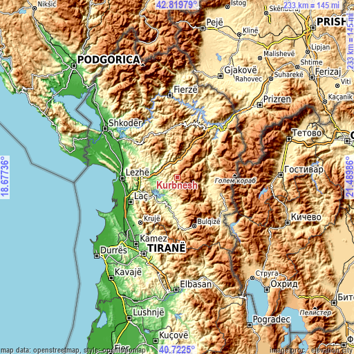
| \ | Map #1 | Topo.Map |
| Scale [m] | 425..1599 m | × |
| Scale [ft] | 1394..5246 ft | × |
| Average | 965.3 m = 3167 ft | × |
| Width | 7.29 km = 4.5 mi | 233.2 km = 144.9 mi |
| Height | 7.29 km = 4.5 mi | 233.2 km = 144.9 mi |
| ↑Max Latitude | 41.812482° | 42.81979° |
| Latitude at center | 41.77972° | 41.77972° |
| ↓Min Latitude | 41.746941° | 40.7225° |
| ← Min Longitude | 20.039665° | 18.67736° |
| Longitude center | 20.08361° | 20.08361° |
| →Max Longitude | 20.127555° | 21.48986° |
Nearby cities:
Cities around Kurbnesh sort by population:
• Rrëshen elevation 94 m
17.3 km,  265°
265°
• Ulëz 162 m
19.1 km,  235°
235°
• Gjegjan 369 m
18.6 km,  341°
341°
• Shëngjin 916 m
18.4 km,  28°
28°
• Lis 491 m
16.9 km,  179°
179°
• Fushë-Lurë 1065 m
12.6 km,  76°
76°
• Derjan 477 m
12 km,  190°
190°
• Rukaj 332 m
11.9 km,  206°
206°
• Blinisht 342 m
11.4 km,  322°
322°
• Macukull 1062 m
10.4 km,  167°
167°
• Orosh 746 m
6 km,  359°
359°
• Kthella e Epërme 600 m
4.1 km,  330°
330°
Multilingual:
 En español:
Kurbnesh elevación 745 m.
 En France:
Kurbnesh élévation 745 m.
 Auf Deutsch:
Kurbnesh höhe über dem Meeresspiegel ist 745 m.

Sources and notes:
- [note 1] Map square and city borders are not equal. Map elevation data is calculated only from area inside that square.
- [src 1] Elevation data from geonames database provided with same terms of usage.
- [src 2] The elevation map of Kurbnesh is generated using elevation data from NASA's 3 arcsec (90m) resolution SRTM data.
- [src 3] Base (background) map © OpenStreetMap contributors tiles are generated by Geofabrik and OpenTopoMap.
Copyright & License:
This Kurbnesh Elevation Map is licensed under CC BY-SA. You may reuse any part from this page, if you give a proper credit by linking to this URL:
 More info on terms of use page.