Kalis elevation
Kalis (Kukës, Rrethi i Kukësit), Albania elevation is 762 meters and Kalis elevation in feet is 2500 ft above sea level [src 1]. Kalis is a seat of a third-order administrative division (feature code) with elevation that is 388 meters (1273 ft) bigger than average city elevation in Albania.
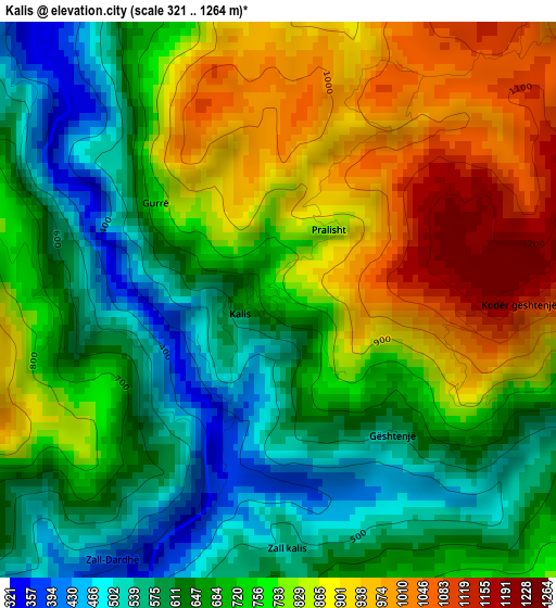
Below is the Elevation map of Kalis, which displays elevation range with different colors. Scale of the first map is from 321 to 1264 m (1053 to 4147 ft) with average elevation of 741.5 meters (=2433 ft) [note 1]
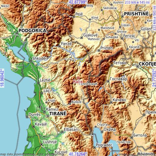
These maps also provides idea of topography and contour of this city, they are displayed at different zoom levels. More info about maps, scale and edge coordinates you can find below images.
| \ | Map #1 | Topo.Map |
| Scale [m] | 321..1264 m | × |
| Scale [ft] | 1053..4147 ft | × |
| Average | 741.5 m = 2433 ft | × |
| Width | 7.28 km = 4.5 mi | 233 km = 144.8 mi |
| Height | 7.28 km = 4.5 mi | 233 km = 144.8 mi |
| ↑Max Latitude | 41.871622° | 42.87799° |
| Latitude at center | 41.83889° | 41.83889° |
| ↓Min Latitude | 41.806141° | 40.78264° |
| ← Min Longitude | 20.322725° | 18.96042° |
| Longitude center | 20.36667° | 20.36667° |
| →Max Longitude | 20.410615° | 21.77292° |
Nearby cities:
Cities around Kalis sort by population:
• Tomin elevation 686 m
17.1 km,  164°
164°
• Kastriot 562 m
12.2 km,  175°
175°
• Kokaj 1278 m
12.2 km,  69°
69°
• Arras 417 m
12 km,  197°
197°
• Fushë-Lurë 1065 m
11.7 km,  251°
251°
• Arrën 1054 m
10.5 km,  321°
321°
• Fushë-Çidhnë 401 m
9 km,  193°
193°
• Ujmisht 594 m
7.9 km,  348°
348°
• Bushtricë 841 m
6.4 km,  46°
46°
• Zall-Reç 488 m
5.7 km, 316°
• Sllovë 914 m
5.4 km,  140°
140°
• Zall-Dardhë 397 m
4.4 km,  215°
215°
Multilingual:
 En español:
Kalis elevación 762 m.
 En France:
Kalis élévation 762 m.


Sources and notes:
- [note 1] Map square and city borders are not equal. Map elevation data is calculated only from area inside that square.
- [src 1] Elevation data from geonames database provided with same terms of usage.
- [src 2] The elevation map of Kalis is generated using elevation data from NASA's 3 arcsec (90m) resolution SRTM data.
- [src 3] Base (background) map © OpenStreetMap contributors tiles are generated by Geofabrik and OpenTopoMap.
Copyright & License:
This Kalis Elevation Map is licensed under CC BY-SA. You may reuse any part from this page, if you give a proper credit by linking to this URL:
 More info on terms of use page.