Gurra e Vogël elevation
Gurra e Vogël (Dibër, Rrethi i Matit), Albania elevation is 512 meters and Gurra e Vogël elevation in feet is 1680 ft above sea level [src 1]. Gurra e Vogël is a seat of a third-order administrative division (feature code) with elevation that is 138 meters (453 ft) bigger than average city elevation in Albania.
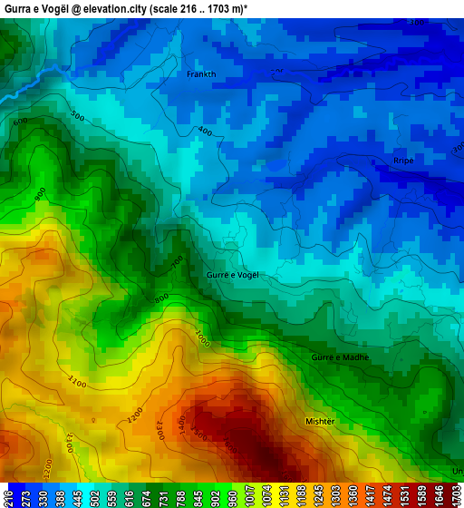
Below is the Elevation map of Gurra e Vogël, which displays elevation range with different colors. Scale of the first map is from 216 to 1703 m (709 to 5587 ft) with average elevation of 707.8 meters (=2322 ft) [note 1]
These maps also provides idea of topography and contour of this city, they are displayed at different zoom levels. More info about maps, scale and edge coordinates you can find below images.
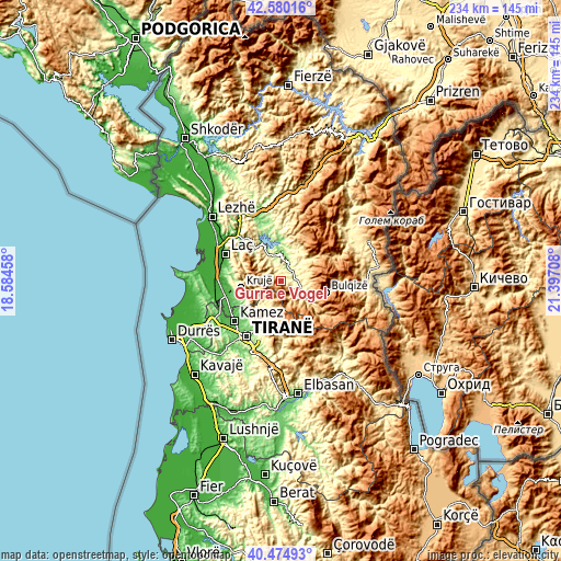
| \ | Map #1 | Topo.Map |
| Scale [m] | 216..1703 m | × |
| Scale [ft] | 709..5587 ft | × |
| Average | 707.8 m = 2322 ft | × |
| Width | 7.32 km = 4.5 mi | 234.1 km = 145.5 mi |
| Height | 7.32 km = 4.5 mi | 234.1 km = 145.5 mi |
| ↑Max Latitude | 41.568996° | 42.58016° |
| Latitude at center | 41.53611° | 41.53611° |
| ↓Min Latitude | 41.503207° | 40.47493° |
| ← Min Longitude | 19.946885° | 18.58458° |
| Longitude center | 19.99083° | 19.99083° |
| →Max Longitude | 20.034775° | 21.39708° |
Nearby cities:
Cities around Gurra e Vogël sort by population:
• Krujë elevation 509 m
16.8 km,  259°
259°
• Burrel 315 m
8.4 km,  10°
10°
• Klos 257 m
8.6 km,  112°
112°
• Rukaj 332 m
16.6 km, 8°
• Derjan 477 m
16.3 km,  20°
20°
• Zall-Bastar 376 m
12.9 km,  203°
203°
• Lis 491 m
12.8 km,  37°
37°
• Cudhi Zall 746 m
12.4 km, 256°
• Baz 319 m
11.8 km,  334°
334°
• Xibër-Murrizë 842 m
9.5 km,  162°
162°
• Suç 281 m
6.8 km,  47°
47°
• Kombësi 317 m
5.1 km,  355°
355°
Multilingual:
 En español:
Gurra e Vogël elevación 512 m.
 En France:
Gurra e Vogël élévation 512 m.
 Auf Deutsch:
Gurra e Vogël höhe über dem Meeresspiegel ist 512 m.

Sources and notes:
- [note 1] Map square and city borders are not equal. Map elevation data is calculated only from area inside that square.
- [src 1] Elevation data from geonames database provided with same terms of usage.
- [src 2] The elevation map of Gurra e Vogël is generated using elevation data from NASA's 3 arcsec (90m) resolution SRTM data.
- [src 3] Base (background) map © OpenStreetMap contributors tiles are generated by Geofabrik and OpenTopoMap.
Copyright & License:
This Gurra e Vogël Elevation Map is licensed under CC BY-SA. You may reuse any part from this page, if you give a proper credit by linking to this URL:
 More info on terms of use page.