Kaçinar elevation
Kaçinar (Lezhë, Rrethi i Mirditës), Albania elevation is 430 meters and Kaçinar elevation in feet is 1411 ft above sea level [src 1]. Kaçinar is a seat of a third-order administrative division (feature code) with elevation that is 56 meters (184 ft) bigger than average city elevation in Albania.
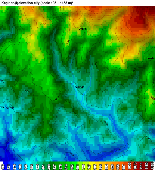
Below is the Elevation map of Kaçinar, which displays elevation range with different colors. Scale of the first map is from 193 to 1188 m (633 to 3898 ft) with average elevation of 543.7 meters (=1784 ft) [note 1]
These maps also provides idea of topography and contour of this city, they are displayed at different zoom levels. More info about maps, scale and edge coordinates you can find below images.
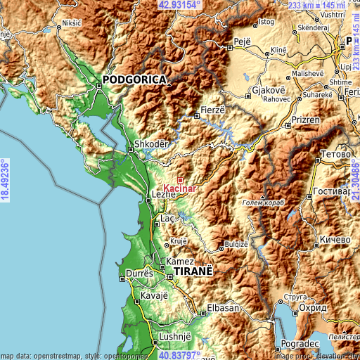
| \ | Map #1 | Topo.Map |
| Scale [m] | 193..1188 m | × |
| Scale [ft] | 633..3898 ft | × |
| Average | 543.7 m = 1784 ft | × |
| Width | 7.27 km = 4.5 mi | 232.8 km = 144.7 mi |
| Height | 7.27 km = 4.5 mi | 232.8 km = 144.7 mi |
| ↑Max Latitude | 41.926034° | 42.93154° |
| Latitude at center | 41.89333° | 41.89333° |
| ↓Min Latitude | 41.860609° | 40.83797° |
| ← Min Longitude | 19.854665° | 18.49236° |
| Longitude center | 19.89861° | 19.89861° |
| →Max Longitude | 19.942555° | 21.30486° |
Nearby cities:
Cities around Kaçinar sort by population:
• Rrëshen elevation 94 m
14.1 km,  187°
187°
• Pukë 799 m
16.8 km,  0°
0°
• Rubik 79 m
16.2 km,  215°
215°
• Kurbnesh 745 m
19.9 km,  129°
129°
• Qerret 652 m
18.5 km,  344°
344°
• Kallmeti i Madh 61 m
18.2 km,  254°
254°
• Rrapë 792 m
17.8 km,  19°
19°
• Orosh 746 m
16.7 km,  113°
113°
• Kthella e Epërme 600 m
16.1 km,  124°
124°
• Gjegjan 369 m
10.5 km,  62°
62°
• Blinisht 342 m
9.1 km, 112°
• Ungrej 253 m
8.8 km,  256°
256°
Multilingual:
 En español:
Kaçinar elevación 430 m.
 En France:
Kaçinar élévation 430 m.


Sources and notes:
- [note 1] Map square and city borders are not equal. Map elevation data is calculated only from area inside that square.
- [src 1] Elevation data from geonames database provided with same terms of usage.
- [src 2] The elevation map of Kaçinar is generated using elevation data from NASA's 3 arcsec (90m) resolution SRTM data.
- [src 3] Base (background) map © OpenStreetMap contributors tiles are generated by Geofabrik and OpenTopoMap.
Copyright & License:
This Kaçinar Elevation Map is licensed under CC BY-SA. You may reuse any part from this page, if you give a proper credit by linking to this URL:
 More info on terms of use page.