Nicaj-Shosh elevation
Nicaj-Shosh (Shkodër, Rrethi i Shkodrës), Albania elevation is 776 meters and Nicaj-Shosh elevation in feet is 2546 ft above sea level [src 1]. Nicaj-Shosh is a seat of a third-order administrative division (feature code) with elevation that is 402 meters (1319 ft) bigger than average city elevation in Albania.
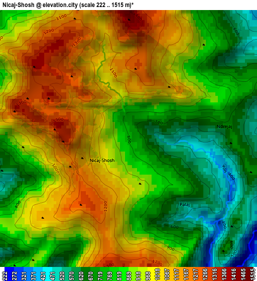
Below is the Elevation map of Nicaj-Shosh, which displays elevation range with different colors. Scale of the first map is from 222 to 1515 m (728 to 4970 ft) with average elevation of 900 meters (=2953 ft) [note 1]
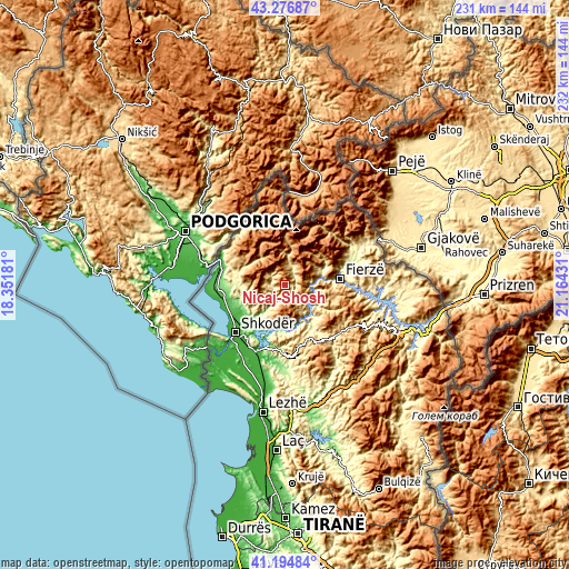
These maps also provides idea of topography and contour of this city, they are displayed at different zoom levels. More info about maps, scale and edge coordinates you can find below images.
| \ | Map #1 | Topo.Map |
| Scale [m] | 222..1515 m | × |
| Scale [ft] | 728..4970 ft | × |
| Average | 900 m = 2953 ft | × |
| Width | 7.23 km = 4.5 mi | 231.5 km = 143.8 mi |
| Height | 7.23 km = 4.5 mi | 231.5 km = 143.8 mi |
| ↑Max Latitude | 42.276964° | 43.27687° |
| Latitude at center | 42.24444° | 42.24444° |
| ↓Min Latitude | 42.2119° | 41.19484° |
| ← Min Longitude | 19.714115° | 18.35181° |
| Longitude center | 19.75806° | 19.75806° |
| →Max Longitude | 19.802005° | 21.16431° |
Nearby cities:
Cities around Nicaj-Shosh sort by population:
• Pukë elevation 799 m
25.1 km,  152°
152°
• Valbonë 932 m
25.5 km,  25°
25°
• Kastrat 752 m
25.2 km,  298°
298°
• Grudë-Fushë 66 m
23.4 km,  246°
246°
• Qerret 652 m
22.3 km,  162°
162°
• Gruemirë 85 m
21.9 km,  244°
244°
• Fierzë 303 m
21.4 km,  85°
85°
• Iballë 765 m
21.1 km,  107°
107°
• Qelëz 234 m
20.6 km, 146°
• Bushat 423 m
18.1 km,  139°
139°
• Lekbibaj 318 m
15.3 km,  68°
68°
• Nicaj-Shalë 633 m
7.2 km, 32°
Multilingual:
 En español:
Nicaj-Shosh elevación 776 m.
 En France:
Nicaj-Shosh élévation 776 m.
 Auf Deutsch:
Nicaj-Shosh höhe über dem Meeresspiegel ist 776 m.

Sources and notes:
- [note 1] Map square and city borders are not equal. Map elevation data is calculated only from area inside that square.
- [src 1] Elevation data from geonames database provided with same terms of usage.
- [src 2] The elevation map of Nicaj-Shosh is generated using elevation data from NASA's 3 arcsec (90m) resolution SRTM data.
- [src 3] Base (background) map © OpenStreetMap contributors tiles are generated by Geofabrik and OpenTopoMap.
Copyright & License:
This Nicaj-Shosh Elevation Map is licensed under CC BY-SA. You may reuse any part from this page, if you give a proper credit by linking to this URL:
 More info on terms of use page.