Kastrat elevation
Kastrat (Shkodër, Rrethi i Malësia e Madhe), Albania elevation is 752 meters and Kastrat elevation in feet is 2467 ft above sea level [src 1]. Kastrat is a seat of a third-order administrative division (feature code) with elevation that is 378 meters (1240 ft) bigger than average city elevation in Albania.
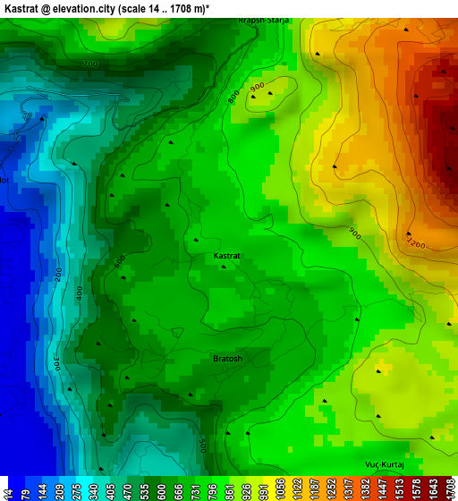
Below is the Elevation map of Kastrat, which displays elevation range with different colors. Scale of the first map is from 14 to 1708 m (46 to 5604 ft) with average elevation of 718.8 meters (=2358 ft) [note 1]
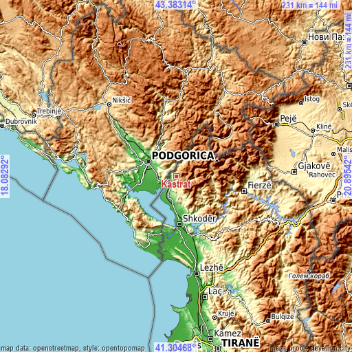
These maps also provides idea of topography and contour of this city, they are displayed at different zoom levels. More info about maps, scale and edge coordinates you can find below images.
| \ | Map #1 | Topo.Map |
| Scale [m] | 14..1708 m | × |
| Scale [ft] | 46..5604 ft | × |
| Average | 718.8 m = 2358 ft | × |
| Width | 7.22 km = 4.5 mi | 231.1 km = 143.6 mi |
| Height | 7.22 km = 4.5 mi | 231.1 km = 143.6 mi |
| ↑Max Latitude | 42.384968° | 43.38314° |
| Latitude at center | 42.3525° | 42.3525° |
| ↓Min Latitude | 42.320015° | 41.30468° |
| ← Min Longitude | 19.445225° | 18.08292° |
| Longitude center | 19.48917° | 19.48917° |
| →Max Longitude | 19.533115° | 20.89542° |
Nearby cities:
Cities around Kastrat sort by population:
• Shkodër elevation 12 m
31.7 km,  176°
176°
• Koplik 63 m
16 km,  195°
195°
• Vukatanë 11 m
36.4 km,  172°
172°
• Lekbibaj 318 m
36.9 km,  100°
100°
• Kuç 9 m
34.9 km, 175°
• Guri i Zi 30 m
34.9 km, 168°
• Valbonë 932 m
34.8 km,  71°
71°
• Nicaj-Shalë 633 m
26.6 km, 102°
• Nicaj-Shosh 776 m
25.2 km,  118°
118°
• Gruemirë 85 m
21.6 km, 173°
• Grudë-Fushë 66 m
21.2 km, 178°
• Hot 91 m
3.8 km,  285°
285°
Multilingual:
 En español:
Kastrat elevación 752 m.
 En France:
Kastrat élévation 752 m.


Sources and notes:
- [note 1] Map square and city borders are not equal. Map elevation data is calculated only from area inside that square.
- [src 1] Elevation data from geonames database provided with same terms of usage.
- [src 2] The elevation map of Kastrat is generated using elevation data from NASA's 3 arcsec (90m) resolution SRTM data.
- [src 3] Base (background) map © OpenStreetMap contributors tiles are generated by Geofabrik and OpenTopoMap.
Copyright & License:
This Kastrat Elevation Map is licensed under CC BY-SA. You may reuse any part from this page, if you give a proper credit by linking to this URL:
 More info on terms of use page.