Roskovec elevation
Roskovec (Fier), Albania elevation is 18 meters and Roskovec elevation in feet is 59 ft above sea level [src 1]. Roskovec is a seat of a third-order administrative division (feature code) with elevation that is 356 meters (1168 ft) smaller than average city elevation in Albania.
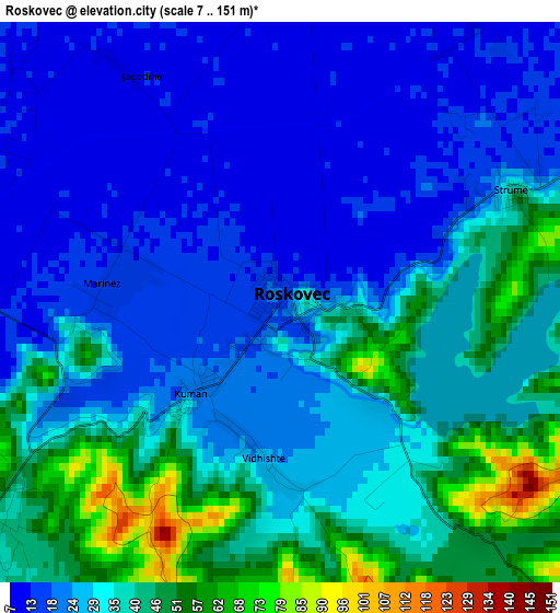
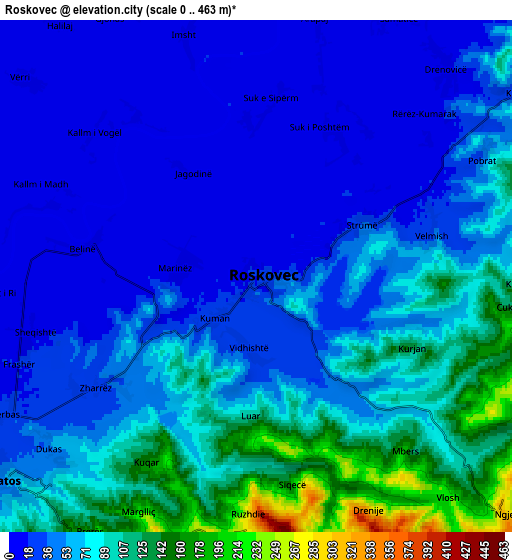
Below is the Elevation map of Roskovec, which displays elevation range with different colors. Scale of the first map is from 7 to 151 m (23 to 495 ft) with average elevation of 30.3 meters (=99 ft) [note 1]
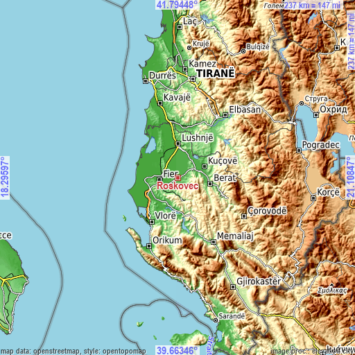
These maps also provides idea of topography and contour of this city, they are displayed at different zoom levels. More info about maps, scale and edge coordinates you can find below images.
| \ | Map #1 | Map #2 | Topo.Map |
| Scale [m] | 7..151 m | 0..463 m | × |
| Scale [ft] | 23..495 ft | 0..1519 ft | × |
| Average | 30.3 m = 99 ft | 60 m = 197 ft | × |
| Width | 7.4 km = 4.6 mi | 14.81 km = 9.2 mi | 236.9 km = 147.2 mi |
| Height | 7.4 km = 4.6 mi | 14.81 km = 9.2 mi | 236.9 km = 147.2 mi |
| ↑Max Latitude | 40.770789° | 40.804062° | 41.79448° |
| Latitude at center | 40.7375° | 40.7375° | 40.7375° |
| ↓Min Latitude | 40.704194° | 40.670871° | 39.66346° |
| ← Min Longitude | 19.658275° | 19.614329° | 18.29597° |
| Longitude center | 19.70222° | 19.70222° | 19.70222° |
| →Max Longitude | 19.746165° | 19.790111° | 21.10847° |
Nearby cities:
Cities around Roskovec sort by population:
• Patos elevation 61 m
9.2 km,  229°
229°
• Patos Fshat 157 m
11.4 km,  202°
202°
• Mbrostar-Urë 33 m
10.5 km,  279°
279°
• Bubullimë 8 m
10.3 km,  330°
330°
• Kutalli 23 m
8.8 km,  54°
54°
• Cukalat 153 m
7.5 km,  96°
96°
• Ruzhdie 268 m
7.4 km,  182°
182°
• Zharrëz 34 m
5.4 km, 234°
• Dushk 50 m
4.8 km, 104°
• Kurjan 116 m
4.3 km,  121°
121°
• Strum 35 m
3.3 km,  63°
63°
• Kuman 20 m
1.8 km, 227°
Multilingual:
 En español:
Roskovec elevación 18 m.
 En France:
Roskovec élévation 18 m.


Sources and notes:
- [note 1] Map square and city borders are not equal. Map elevation data is calculated only from area inside that square.
- [src 1] Elevation data from geonames database provided with same terms of usage.
- [src 2] The elevation map of Roskovec is generated using elevation data from NASA's 3 arcsec (90m) resolution SRTM data.
- [src 3] Base (background) map © OpenStreetMap contributors tiles are generated by Geofabrik and OpenTopoMap.
Copyright & License:
This Roskovec Elevation Map is licensed under CC BY-SA. You may reuse any part from this page, if you give a proper credit by linking to this URL:
 More info on terms of use page.