‘Alāqahdārī Saṟōbī elevation
‘Alāqahdārī Saṟōbī (Paktika, Saṟōbī), Afghanistan elevation is 2400 meters and ‘Alāqahdārī Saṟōbī elevation in feet is 7874 ft above sea level [src 1]. ‘Alāqahdārī Saṟōbī is a seat of a second-order administrative division (feature code) with elevation that is 981 meters (3219 ft) bigger than average city elevation in Afghanistan.
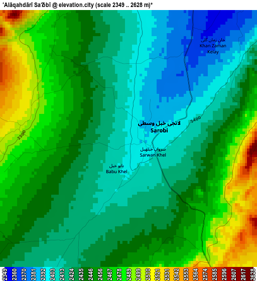
Below is the Elevation map of ‘Alāqahdārī Saṟōbī, which displays elevation range with different colors. Scale of the first map is from 2349 to 2628 m (7707 to 8622 ft) with average elevation of 2440.4 meters (=8007 ft) [note 1]
These maps also provides idea of topography and contour of this city, they are displayed at different zoom levels. More info about maps, scale and edge coordinates you can find below images.
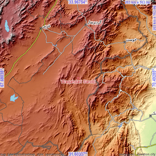
| \ | Map #1 | Topo.Map |
| Scale [m] | 2349..2628 m | × |
| Scale [ft] | 7707..8622 ft | × |
| Average | 2440.4 m = 8007 ft | × |
| Width | 8.22 km = 5.1 mi | 262.9 km = 163.4 mi |
| Height | 8.22 km = 5.1 mi | 262.9 km = 163.4 mi |
| ↑Max Latitude | 32.830244° | 33.96754° |
| Latitude at center | 32.79331° | 32.79331° |
| ↓Min Latitude | 32.756361° | 31.60337° |
| ← Min Longitude | 69.042655° | 67.68035° |
| Longitude center | 69.0866° | 69.0866° |
| →Max Longitude | 69.130545° | 70.49285° |
Nearby cities:
Cities around ‘Alāqahdārī Saṟōbī sort by population:
• Zaṟah Sharan elevation 2154 m
47.9 km,  325°
325°
• Sharan 2145 m
54 km,  321°
321°
• Khayr Kōṯ 2126 m
59.9 km,  276°
276°
• Mutā Khān 2124 m
53.7 km,  337°
337°
• ‘Alāqahdārī Yōsuf Khēl 2239 m
49.9 km,  305°
305°
• Nīkêh 2488 m
47.3 km,  21°
21°
• Zerok-Alakadari 2336 m
45.7 km,  27°
27°
• Yaḩyá Khēl 2136 m
44.1 km,  291°
291°
• Gōmal Kêlay 1827 m
38.2 km,  214°
214°
• Stêr Giyān 2132 m
33.7 km,  52°
52°
• Ōmnah 2595 m
29.6 km, 293°
• Urgun 2208 m
19.8 km, 27°
Multilingual:
 En español:
‘Alāqahdārī Saṟōbī elevación 2400 m.
 En France:
‘Alāqahdārī Saṟōbī élévation 2400 m.
 Auf Deutsch:
‘Alāqahdārī Saṟōbī höhe über dem Meeresspiegel ist 2400 m.
 На русском:
‘Alāqahdārī Saṟōbī высота над уровнем моря 2400 м
Sources and notes:
- [note 1] Map square and city borders are not equal. Map elevation data is calculated only from area inside that square.
- [src 1] Elevation data from geonames database provided with same terms of usage.
- [src 2] The elevation map of ‘Alāqahdārī Saṟōbī is generated using elevation data from NASA's 3 arcsec (90m) resolution SRTM data.
- [src 3] Base (background) map © OpenStreetMap contributors tiles are generated by Geofabrik and OpenTopoMap.
Copyright & License:
This ‘Alāqahdārī Saṟōbī Elevation Map is licensed under CC BY-SA. You may reuse any part from this page, if you give a proper credit by linking to this URL:
 More info on terms of use page.