Urgun elevation
Urgun (Paktika, Urgun District), Afghanistan elevation is 2208 meters and Urgun elevation in feet is 7244 ft above sea level [src 1]. Urgun is a seat of a second-order administrative division (feature code) with elevation that is 789 meters (2589 ft) bigger than average city elevation in Afghanistan.
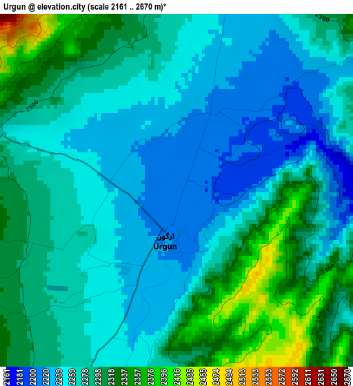
Below is the Elevation map of Urgun, which displays elevation range with different colors. Scale of the first map is from 2161 to 2670 m (7090 to 8760 ft) with average elevation of 2276.6 meters (=7469 ft) [note 1]
These maps also provides idea of topography and contour of this city, they are displayed at different zoom levels. More info about maps, scale and edge coordinates you can find below images.
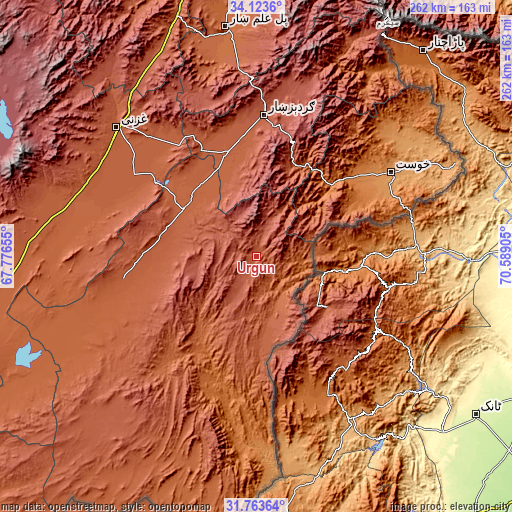
| \ | Map #1 | Topo.Map |
| Scale [m] | 2161..2670 m | × |
| Scale [ft] | 7090..8760 ft | × |
| Average | 2276.6 m = 7469 ft | × |
| Width | 8.2 km = 5.1 mi | 262.4 km = 163 mi |
| Height | 8.2 km = 5.1 mi | 262.4 km = 163 mi |
| ↑Max Latitude | 32.988368° | 34.1236° |
| Latitude at center | 32.9515° | 32.9515° |
| ↓Min Latitude | 32.914616° | 31.76364° |
| ← Min Longitude | 69.138855° | 67.77655° |
| Longitude center | 69.1828° | 69.1828° |
| →Max Longitude | 69.226745° | 70.58905° |
Nearby cities:
Cities around Urgun sort by population:
• Zaṟah Sharan elevation 2154 m
42.4 km,  300°
300°
• Sharan 2145 m
49 km, 300°
• Dwah Manḏay 1543 m
52.5 km,  45°
45°
• ‘Alāqahdārī Yōsuf Khēl 2239 m
50.9 km,  282°
282°
• Yaḩyá Khēl 2136 m
50.1 km,  268°
268°
• Mutā Khān 2124 m
43.6 km,  317°
317°
• Spērah 1743 m
41.7 km, 48°
• Ōmnah 2595 m
36.5 km,  261°
261°
• Nīkêh 2488 m
27.7 km,  17°
17°
• Zerok-Alakadari 2336 m
26 km,  27°
27°
• ‘Alāqahdārī Saṟōbī 2400 m
19.8 km,  207°
207°
• Stêr Giyān 2132 m
18 km,  80°
80°
Multilingual:
 En español:
Urgun elevación 2208 m.
 En France:
Urgun élévation 2208 m.


Sources and notes:
- [note 1] Map square and city borders are not equal. Map elevation data is calculated only from area inside that square.
- [src 1] Elevation data from geonames database provided with same terms of usage.
- [src 2] The elevation map of Urgun is generated using elevation data from NASA's 3 arcsec (90m) resolution SRTM data.
- [src 3] Base (background) map © OpenStreetMap contributors tiles are generated by Geofabrik and OpenTopoMap.
Copyright & License:
This Urgun Elevation Map is licensed under CC BY-SA. You may reuse any part from this page, if you give a proper credit by linking to this URL:
 More info on terms of use page.