Qaranghū Tōghaī elevation
Qaranghū Tōghaī (Balkh, Kaldār), Afghanistan elevation is 301 meters and Qaranghū Tōghaī elevation in feet is 988 ft above sea level [src 1]. Qaranghū Tōghaī is a seat of a second-order administrative division (feature code) with elevation that is 1118 meters (3668 ft) smaller than average city elevation in Afghanistan.
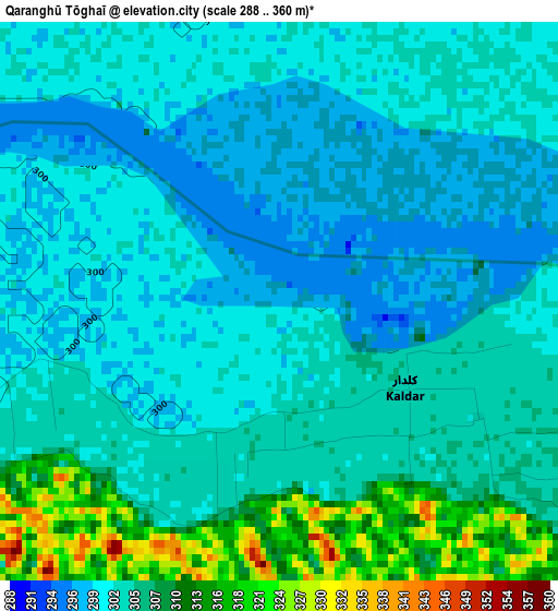
Below is the Elevation map of Qaranghū Tōghaī, which displays elevation range with different colors. Scale of the first map is from 288 to 360 m (945 to 1181 ft) with average elevation of 304.5 meters (=999 ft) [note 1]
These maps also provides idea of topography and contour of this city, they are displayed at different zoom levels. More info about maps, scale and edge coordinates you can find below images.
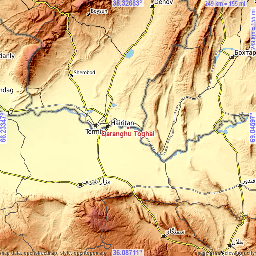
| \ | Map #1 | Topo.Map |
| Scale [m] | 288..360 m | × |
| Scale [ft] | 945..1181 ft | × |
| Average | 304.5 m = 999 ft | × |
| Width | 7.78 km = 4.8 mi | 249 km = 154.7 mi |
| Height | 7.78 km = 4.8 mi | 249 km = 154.7 mi |
| ↑Max Latitude | 37.250269° | 38.32683° |
| Latitude at center | 37.21528° | 37.21528° |
| ↓Min Latitude | 37.180275° | 36.08711° |
| ← Min Longitude | 67.595775° | 66.23347° |
| Longitude center | 67.63972° | 67.63972° |
| →Max Longitude | 67.683665° | 69.04597° |
Nearby cities:
Cities around Qaranghū Tōghaī sort by population:
• Mazār-e Sharīf elevation 361 m
73.3 km,  219°
219°
• Balkh 348 m
83.4 km,  232°
232°
• Khulm 445 m
57.8 km,  174°
174°
• Aībak 969 m
110.9 km,  162°
162°
• Qarāwul 337 m
101 km,  89°
89°
• Imām Şāḩib 358 m
114.9 km, 91°
• Qarchī Gak 306 m
77.9 km,  255°
255°
• Dowr-e Rabāţ 390 m
117.7 km,  119°
119°
• Faīẕābād 312 m
113.6 km,  247°
247°
• Chimtāl 355 m
95.3 km, 231°
• Dehdādī 398 m
84.1 km, 223°
• Dowlatābād 312 m
76.9 km, 250°
Multilingual:
 En español:
Qaranghū Tōghaī elevación 301 m.
 En France:
Qaranghū Tōghaī élévation 301 m.
 Auf Deutsch:
Qaranghū Tōghaī höhe über dem Meeresspiegel ist 301 m.

Sources and notes:
- [note 1] Map square and city borders are not equal. Map elevation data is calculated only from area inside that square.
- [src 1] Elevation data from geonames database provided with same terms of usage.
- [src 2] The elevation map of Qaranghū Tōghaī is generated using elevation data from NASA's 3 arcsec (90m) resolution SRTM data.
- [src 3] Base (background) map © OpenStreetMap contributors tiles are generated by Geofabrik and OpenTopoMap.
Copyright & License:
This Qaranghū Tōghaī Elevation Map is licensed under CC BY-SA. You may reuse any part from this page, if you give a proper credit by linking to this URL:
 More info on terms of use page.