Mazār-e Sharīf elevation
Mazār-e Sharīf (Balkh), Afghanistan elevation is 361 meters and Mazār-e Sharīf elevation in feet is 1184 ft above sea level [src 1]. Mazār-e Sharīf is a seat of a first-order administrative division (feature code) with elevation that is 1058 meters (3471 ft) smaller than average city elevation in Afghanistan.
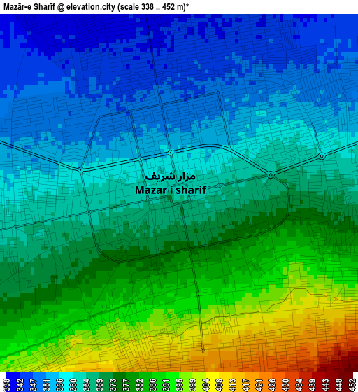
Below is the Elevation map of Mazār-e Sharīf, which displays elevation range with different colors. Scale of the first map is from 338 to 452 m (1109 to 1483 ft) with average elevation of 369.4 meters (=1212 ft) [note 1]
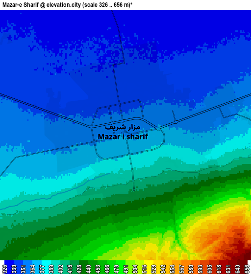
These maps also provides idea of topography and contour of this city, they are displayed at different zoom levels. More info about maps, scale and edge coordinates you can find below images.
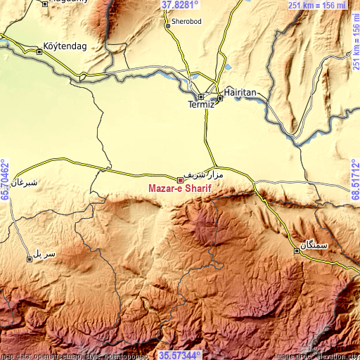
| \ | Map #1 | Map #2 | Topo.Map |
| Scale [m] | 338..452 m | 326..656 m | × |
| Scale [ft] | 1109..1483 ft | 1070..2152 ft | × |
| Average | 369.4 m = 1212 ft | 388.9 m = 1276 ft | × |
| Width | 7.83 km = 4.9 mi | 15.67 km = 9.7 mi | 250.7 km = 155.8 mi |
| Height | 7.83 km = 4.9 mi | 15.67 km = 9.7 mi | 250.7 km = 155.8 mi |
| ↑Max Latitude | 36.744262° | 36.779468° | 37.8281° |
| Latitude at center | 36.70904° | 36.70904° | 36.70904° |
| ↓Min Latitude | 36.673802° | 36.638547° | 35.57344° |
| ← Min Longitude | 67.066925° | 67.022979° | 65.70462° |
| Longitude center | 67.11087° | 67.11087° | 67.11087° |
| →Max Longitude | 67.154815° | 67.198761° | 68.51712° |
Nearby cities:
Cities around Mazār-e Sharīf sort by population:
• Balkh elevation 348 m
19.8 km,  285°
285°
• Khulm 445 m
52.4 km,  91°
91°
• Qarchī Gak 306 m
46.6 km,  322°
322°
• Lab-Sar 1011 m
79.7 km,  197°
197°
• Dehī 1271 m
84.9 km,  169°
169°
• Mardīān 287 m
79 km, 293°
• Āq Kupruk 719 m
73.6 km, 199°
• Qaranghū Tōghaī 301 m
73.3 km,  39°
39°
• Faīẕābād 312 m
59.4 km,  282°
282°
• Dowlatābād 312 m
40.4 km, 320°
• Chimtāl 355 m
27.6 km,  262°
262°
• Dehdādī 398 m
11.6 km,  244°
244°
Multilingual:
 En español:
Mazār-e Šarīf elevación 361 m.
 En France:
Mazār-e Sharīf élévation 361 m.
 Auf Deutsch:
Masar-e Scharif höhe über dem Meeresspiegel ist 361 m.

Sources and notes:
- [note 1] Map square and city borders are not equal. Map elevation data is calculated only from area inside that square.
- [src 1] Elevation data from geonames database provided with same terms of usage.
- [src 2] The elevation map of Mazār-e Sharīf is generated using elevation data from NASA's 3 arcsec (90m) resolution SRTM data.
- [src 3] Base (background) map © OpenStreetMap contributors tiles are generated by Geofabrik and OpenTopoMap.
Copyright & License:
This Mazār-e Sharīf Elevation Map is licensed under CC BY-SA. You may reuse any part from this page, if you give a proper credit by linking to this URL:
 More info on terms of use page.