Amānzī elevation
Amānzī (Kandahar, Shōrābak), Afghanistan elevation is 993 meters and Amānzī elevation in feet is 3258 ft above sea level [src 1]. Amānzī is a seat of a second-order administrative division (feature code) with elevation that is 426 meters (1398 ft) smaller than average city elevation in Afghanistan.
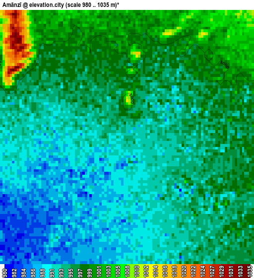
Below is the Elevation map of Amānzī, which displays elevation range with different colors. Scale of the first map is from 980 to 1035 m (3215 to 3396 ft) with average elevation of 994.4 meters (=3262 ft) [note 1]
These maps also provides idea of topography and contour of this city, they are displayed at different zoom levels. More info about maps, scale and edge coordinates you can find below images.
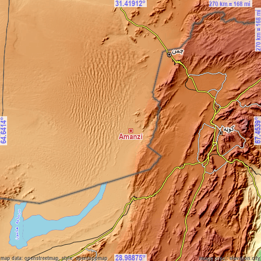
| \ | Map #1 | Topo.Map |
| Scale [m] | 980..1035 m | × |
| Scale [ft] | 3215..3396 ft | × |
| Average | 994.4 m = 3262 ft | × |
| Width | 8.45 km = 5.3 mi | 270.2 km = 167.9 mi |
| Height | 8.45 km = 5.3 mi | 270.2 km = 167.9 mi |
| ↑Max Latitude | 30.249409° | 31.41912° |
| Latitude at center | 30.21144° | 30.21144° |
| ↓Min Latitude | 30.173456° | 28.98875° |
| ← Min Longitude | 66.003705° | 64.6414° |
| Longitude center | 66.04765° | 66.04765° |
| →Max Longitude | 66.091595° | 67.4539° |
Nearby cities:
Cities around Amānzī sort by population:
• Kandahār elevation 1007 m
159.2 km,  348°
348°
• Markaz-e Ḩukūmat-e Darwēshān 714 m
204.8 km,  300°
300°
• Khān Neshīn 635 m
219.9 km,  279°
279°
• Chinār 1132 m
219.7 km,  335°
335°
• ‘Alāqahdārī Aṯghar 1827 m
210.4 km,  36°
36°
• Zīārat-e Shāh Maqşūd 1577 m
204.6 km, 344°
• Kishk-e Nakhūd 944 m
183.5 km,  328°
328°
• Shahr-e Şafā 1257 m
179 km,  8°
8°
• Babasakhib 1014 m
165.4 km, 347°
• Pāshmūl 946 m
160.7 km, 338°
• Khūgyāṉī 1311 m
158.6 km,  18°
18°
• Spīn Bōldak 1218 m
94.5 km, 20°
Multilingual:
 En español:
Amānzī elevación 993 m.
 En France:
Amānzī élévation 993 m.


Sources and notes:
- [note 1] Map square and city borders are not equal. Map elevation data is calculated only from area inside that square.
- [src 1] Elevation data from geonames database provided with same terms of usage.
- [src 2] The elevation map of Amānzī is generated using elevation data from NASA's 3 arcsec (90m) resolution SRTM data.
- [src 3] Base (background) map © OpenStreetMap contributors tiles are generated by Geofabrik and OpenTopoMap.
Copyright & License:
This Amānzī Elevation Map is licensed under CC BY-SA. You may reuse any part from this page, if you give a proper credit by linking to this URL:
 More info on terms of use page.