Anār Darah elevation
Anār Darah (Farah), Afghanistan elevation is 778 meters and Anār Darah elevation in feet is 2552 ft above sea level [src 1]. Anār Darah is a seat of a second-order administrative division (feature code) with elevation that is 641 meters (2103 ft) smaller than average city elevation in Afghanistan.
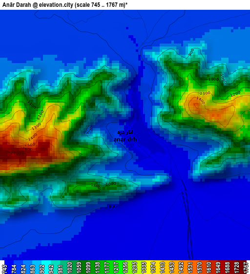
Below is the Elevation map of Anār Darah, which displays elevation range with different colors. Scale of the first map is from 745 to 1767 m (2444 to 5797 ft) with average elevation of 921.9 meters (=3025 ft) [note 1]
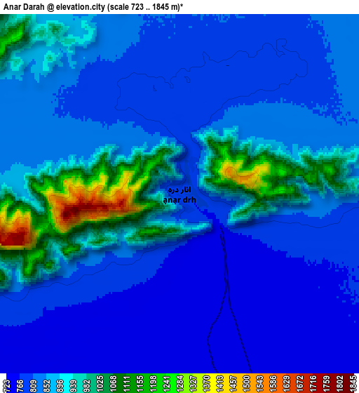
These maps also provides idea of topography and contour of this city, they are displayed at different zoom levels. More info about maps, scale and edge coordinates you can find below images.
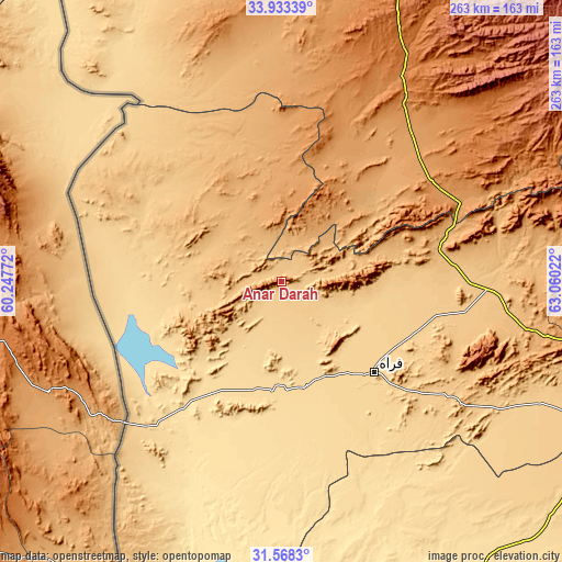
| \ | Map #1 | Map #2 | Topo.Map |
| Scale [m] | 745..1767 m | 723..1845 m | × |
| Scale [ft] | 2444..5797 ft | 2372..6053 ft | × |
| Average | 921.9 m = 3025 ft | 863.2 m = 2832 ft | × |
| Width | 8.22 km = 5.1 mi | 16.44 km = 10.2 mi | 263 km = 163.4 mi |
| Height | 8.22 km = 5.1 mi | 16.44 km = 10.2 mi | 263 km = 163.4 mi |
| ↑Max Latitude | 32.795648° | 32.832582° | 33.93339° |
| Latitude at center | 32.7587° | 32.7587° | 32.7587° |
| ↓Min Latitude | 32.721736° | 32.684757° | 31.5683° |
| ← Min Longitude | 61.610025° | 61.566079° | 60.24772° |
| Longitude center | 61.65397° | 61.65397° | 61.65397° |
| →Max Longitude | 61.697915° | 61.741861° | 63.06022° |
Nearby cities:
Cities around Anār Darah sort by population:
• Farah elevation 662 m
60.8 km,  134°
134°
• Shīnḏanḏ 1071 m
76 km,  37°
37°
• Kushk 1115 m
65.9 km,  24°
24°
• Khāsh 579 m
173.6 km,  141°
141°
• Chahār Burj 943 m
172.6 km, 16°
• Zindah Jān 834 m
176.3 km,  2°
2°
• Guz̄arah 983 m
169.7 km, 17°
• Markaz-e Ḩukūmat-e Sulţān-e Bakwāh 724 m
134.4 km,  115°
115°
• Lāsh-e Juwayn 513 m
116.2 km,  181°
181°
• Adraskan 1352 m
114.1 km,  30°
30°
• Dū Qal‘ah 557 m
71.2 km,  195°
195°
• Kushkak 612 m
53.6 km,  193°
193°
Multilingual:
 En español:
Anār Darah elevación 778 m.
 En France:
Anār Darah élévation 778 m.
 Auf Deutsch:
Anār Darah höhe über dem Meeresspiegel ist 778 m.

Sources and notes:
- [note 1] Map square and city borders are not equal. Map elevation data is calculated only from area inside that square.
- [src 1] Elevation data from geonames database provided with same terms of usage.
- [src 2] The elevation map of Anār Darah is generated using elevation data from NASA's 3 arcsec (90m) resolution SRTM data.
- [src 3] Base (background) map © OpenStreetMap contributors tiles are generated by Geofabrik and OpenTopoMap.
Copyright & License:
This Anār Darah Elevation Map is licensed under CC BY-SA. You may reuse any part from this page, if you give a proper credit by linking to this URL:
 More info on terms of use page.