Bāsawul elevation
Bāsawul (Nangarhar, Mohmand Darah), Afghanistan elevation is 464 meters and Bāsawul elevation in feet is 1522 ft above sea level [src 1]. Bāsawul is a seat of a second-order administrative division (feature code) with elevation that is 955 meters (3133 ft) smaller than average city elevation in Afghanistan.
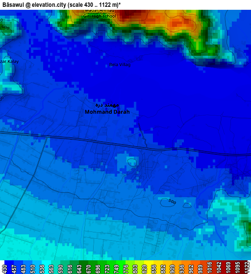
Below is the Elevation map of Bāsawul, which displays elevation range with different colors. Scale of the first map is from 430 to 1122 m (1411 to 3681 ft) with average elevation of 504.9 meters (=1656 ft) [note 1]
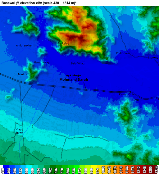
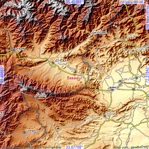
These maps also provides idea of topography and contour of this city, they are displayed at different zoom levels. More info about maps, scale and edge coordinates you can find below images.
| \ | Map #1 | Map #2 | Topo.Map |
| Scale [m] | 430..1122 m | 430..1314 m | × |
| Scale [ft] | 1411..3681 ft | 1411..4311 ft | × |
| Average | 504.9 m = 1656 ft | 567.2 m = 1861 ft | × |
| Width | 8.08 km = 5 mi | 16.16 km = 10 mi | 258.5 km = 160.6 mi |
| Height | 8.08 km = 5 mi | 16.16 km = 10 mi | 258.5 km = 160.6 mi |
| ↑Max Latitude | 34.283808° | 34.32011° | 35.40185° |
| Latitude at center | 34.24749° | 34.24749° | 34.24749° |
| ↓Min Latitude | 34.211156° | 34.174807° | 33.07708° |
| ← Min Longitude | 70.828235° | 70.784289° | 69.46593° |
| Longitude center | 70.87218° | 70.87218° | 70.87218° |
| →Max Longitude | 70.916125° | 70.960071° | 72.27843° |
Nearby cities:
Cities around Bāsawul sort by population:
• Jalālābād elevation 575 m
43.4 km,  297°
297°
• Markaz-e Woluswalī-ye Āchīn 972 m
20.3 km,  228°
228°
• Pachīr wa Āgām 1241 m
54.9 km,  264°
264°
• Qal‘ah-ye Shāhī 894 m
51.6 km,  330°
330°
• Tsowkêy 725 m
49.7 km,  5°
5°
• Khafizan 909 m
46.1 km,  275°
275°
• Sheywah 602 m
44.5 km,  324°
324°
• Nūrgal 679 m
41.9 km,  346°
346°
• Kōṯowāl 1464 m
41.1 km,  247°
247°
• Sangar Sarāy 517 m
27.8 km,  309°
309°
• Kai 945 m
19.4 km, 226°
• Gōshtah 483 m
15.9 km, 320°
Multilingual:
 En español:
Bāsawul elevación 464 m.
 En France:
Bāsawul élévation 464 m.


Sources and notes:
- [note 1] Map square and city borders are not equal. Map elevation data is calculated only from area inside that square.
- [src 1] Elevation data from geonames database provided with same terms of usage.
- [src 2] The elevation map of Bāsawul is generated using elevation data from NASA's 3 arcsec (90m) resolution SRTM data.
- [src 3] Base (background) map © OpenStreetMap contributors tiles are generated by Geofabrik and OpenTopoMap.
Copyright & License:
This Bāsawul Elevation Map is licensed under CC BY-SA. You may reuse any part from this page, if you give a proper credit by linking to this URL:
 More info on terms of use page.