Ghazni elevation
Ghazni, Afghanistan elevation is 2179 meters and Ghazni elevation in feet is 7149 ft above sea level [src 1]. Ghazni is a seat of a first-order administrative division (feature code) with elevation that is 760 meters (2493 ft) bigger than average city elevation in Afghanistan.
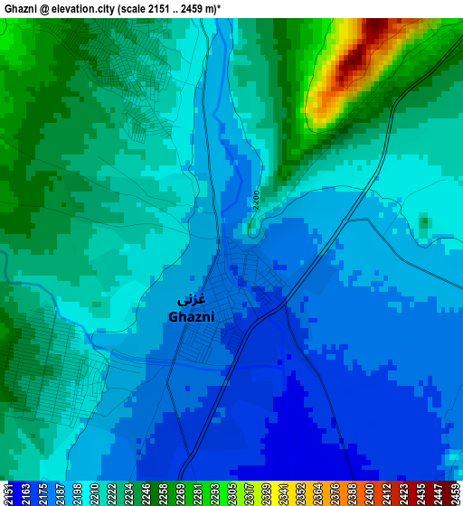
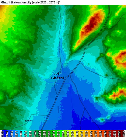
Below is the Elevation map of Ghazni, which displays elevation range with different colors. Scale of the first map is from 2151 to 2459 m (7057 to 8068 ft) with average elevation of 2211.2 meters (=7255 ft) [note 1]
These maps also provides idea of topography and contour of this city, they are displayed at different zoom levels. More info about maps, scale and edge coordinates you can find below images.
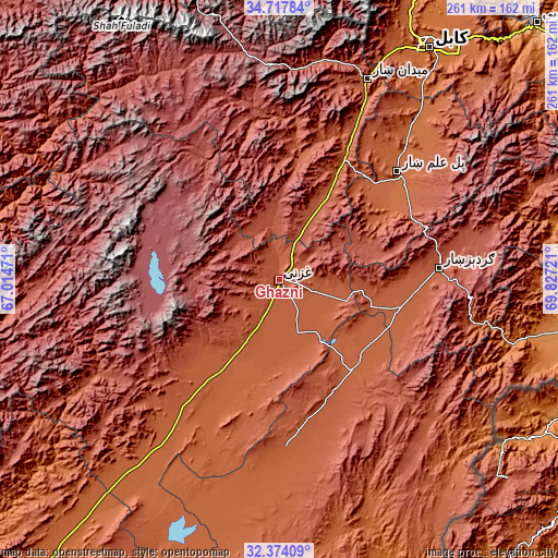
| \ | Map #1 | Map #2 | Topo.Map |
| Scale [m] | 2151..2459 m | 2128..2573 m | × |
| Scale [ft] | 7057..8068 ft | 6982..8442 ft | × |
| Average | 2211.2 m = 7255 ft | 2252.1 m = 7389 ft | × |
| Width | 8.14 km = 5.1 mi | 16.29 km = 10.1 mi | 260.6 km = 161.9 mi |
| Height | 8.14 km = 5.1 mi | 16.29 km = 10.1 mi | 260.6 km = 161.9 mi |
| ↑Max Latitude | 33.590525° | 33.627124° | 34.71784° |
| Latitude at center | 33.55391° | 33.55391° | 33.55391° |
| ↓Min Latitude | 33.51728° | 33.480634° | 32.37409° |
| ← Min Longitude | 68.377015° | 68.333069° | 67.01471° |
| Longitude center | 68.42096° | 68.42096° | 68.42096° |
| →Max Longitude | 68.464905° | 68.508851° | 69.82721° |
Nearby cities:
Cities around Ghazni sort by population:
• Zaṟah Sharan elevation 2154 m
56.9 km,  142°
142°
• Sharan 2145 m
50.9 km,  145°
145°
• Ōkak 3068 m
57.5 km,  311°
311°
• Markaz-e Sayyidābād 2113 m
56.5 km,  28°
28°
• Charkh 2081 m
54.9 km,  60°
60°
• Mutā Khān 2124 m
54.1 km,  130°
130°
• Qarah Bāgh 2089 m
49.1 km,  216°
216°
• Kalān Deh 2502 m
31.5 km,  356°
356°
• Mīray 2077 m
25.6 km,  175°
175°
• Rāmak 2183 m
19.4 km,  100°
100°
• Tōrmay 2296 m
15.1 km,  353°
353°
• Chahār Qal‘ah 2376 m
11.4 km,  269°
269°
Multilingual:
 En español:
Gazni elevación 2179 m.
 En France:
Ghazni élévation 2179 m.


Sources and notes:
- [note 1] Map square and city borders are not equal. Map elevation data is calculated only from area inside that square.
- [src 1] Elevation data from geonames database provided with same terms of usage.
- [src 2] The elevation map of Ghazni is generated using elevation data from NASA's 3 arcsec (90m) resolution SRTM data.
- [src 3] Base (background) map © OpenStreetMap contributors tiles are generated by Geofabrik and OpenTopoMap.
Copyright & License:
This Ghazni Elevation Map is licensed under CC BY-SA. You may reuse any part from this page, if you give a proper credit by linking to this URL:
 More info on terms of use page.