Ghormach elevation
Ghormach (Badghis, Ghōrmāch), Afghanistan elevation is 659 meters and Ghormach elevation in feet is 2162 ft above sea level [src 1]. Ghormach is a seat of a second-order administrative division (feature code) with elevation that is 760 meters (2493 ft) smaller than average city elevation in Afghanistan.
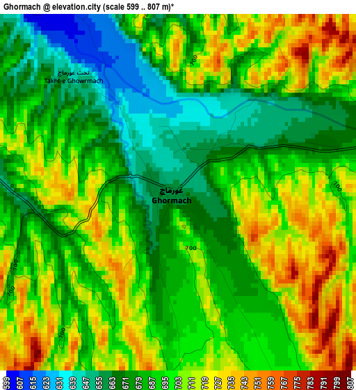
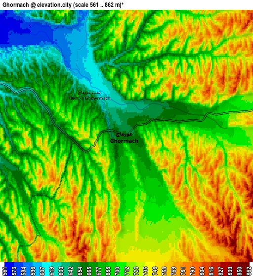
Below is the Elevation map of Ghormach, which displays elevation range with different colors. Scale of the first map is from 599 to 807 m (1965 to 2648 ft) with average elevation of 692.2 meters (=2271 ft) [note 1]
These maps also provides idea of topography and contour of this city, they are displayed at different zoom levels. More info about maps, scale and edge coordinates you can find below images.
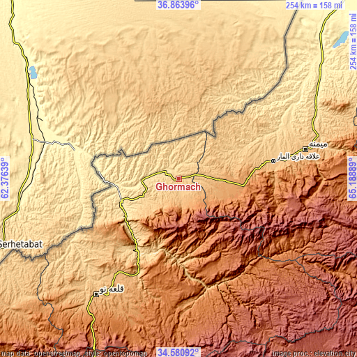
| \ | Map #1 | Map #2 | Topo.Map |
| Scale [m] | 599..807 m | 561..862 m | × |
| Scale [ft] | 1965..2648 ft | 1841..2828 ft | × |
| Average | 692.2 m = 2271 ft | 707.6 m = 2322 ft | × |
| Width | 7.93 km = 4.9 mi | 15.87 km = 9.9 mi | 253.9 km = 157.8 mi |
| Height | 7.93 km = 4.9 mi | 15.87 km = 9.9 mi | 253.8 km = 157.7 mi |
| ↑Max Latitude | 35.766286° | 35.801935° | 36.86396° |
| Latitude at center | 35.73062° | 35.73062° | 35.73062° |
| ↓Min Latitude | 35.694938° | 35.659241° | 34.58092° |
| ← Min Longitude | 63.738695° | 63.694749° | 62.37639° |
| Longitude center | 63.78264° | 63.78264° | 63.78264° |
| →Max Longitude | 63.826585° | 63.870531° | 65.18889° |
Nearby cities:
Cities around Ghormach sort by population:
• Maymana elevation 864 m
92.7 km,  76°
76°
• Qala i Naw 887 m
101.7 km,  215°
215°
• Dowlatābād 413 m
128.6 km,  52°
52°
• Fayẕābād 495 m
115.4 km,  57°
57°
• Qādis 1300 m
107.4 km,  197°
197°
• Lāsh 1927 m
97.9 km,  113°
113°
• Āb-e Kamarī 760 m
96.4 km, 222°
• Sang Atesh 634 m
88.6 km,  232°
232°
• Jawand 945 m
81.3 km,  155°
155°
• ‘Alāqahdārī-ye Almār 840 m
68.7 km, 79°
• Sangalak-i-Kaisar 1258 m
46.3 km,  95°
95°
• Bala Murghab 466 m
44.1 km,  248°
248°
Multilingual:
 En español:
Ghormach elevación 659 m.
 En France:
Ghormach élévation 659 m.
 Auf Deutsch:
Ghormach höhe über dem Meeresspiegel ist 659 m.

Sources and notes:
- [note 1] Map square and city borders are not equal. Map elevation data is calculated only from area inside that square.
- [src 1] Elevation data from geonames database provided with same terms of usage.
- [src 2] The elevation map of Ghormach is generated using elevation data from NASA's 3 arcsec (90m) resolution SRTM data.
- [src 3] Base (background) map © OpenStreetMap contributors tiles are generated by Geofabrik and OpenTopoMap.
Copyright & License:
This Ghormach Elevation Map is licensed under CC BY-SA. You may reuse any part from this page, if you give a proper credit by linking to this URL:
 More info on terms of use page.