Qalāt elevation
Qalāt (Zabul), Afghanistan elevation is 1568 meters and Qalāt elevation in feet is 5144 ft above sea level [src 1]. Qalāt is a seat of a first-order administrative division (feature code) with elevation that is 149 meters (489 ft) bigger than average city elevation in Afghanistan.
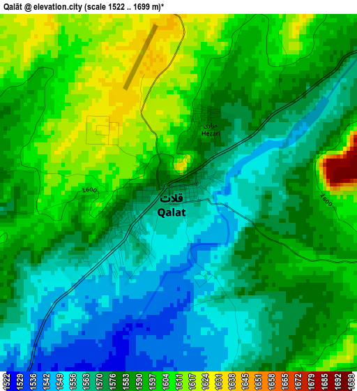
Below is the Elevation map of Qalāt, which displays elevation range with different colors. Scale of the first map is from 1522 to 1699 m (4993 to 5574 ft) with average elevation of 1583.3 meters (=5195 ft) [note 1]
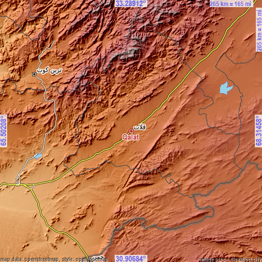
These maps also provides idea of topography and contour of this city, they are displayed at different zoom levels. More info about maps, scale and edge coordinates you can find below images.
| \ | Map #1 | Map #2 | Topo.Map |
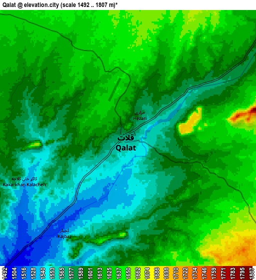
| Scale [m] | 1522..1699 m | 1492..1807 m | × |
| Scale [ft] | 4993..5574 ft | 4895..5928 ft | × |
| Average | 1583.3 m = 5195 ft | 1599.7 m = 5248 ft | × |
| Width | 8.28 km = 5.1 mi | 16.56 km = 10.3 mi | 264.9 km = 164.6 mi |
| Height | 8.28 km = 5.1 mi | 16.56 km = 10.3 mi | 264.9 km = 164.6 mi |
| ↑Max Latitude | 32.142967° | 32.180169° | 33.28912° |
| Latitude at center | 32.10575° | 32.10575° | 32.10575° |
| ↓Min Latitude | 32.068518° | 32.03127° | 30.90684° |
| ← Min Longitude | 66.864385° | 66.820439° | 65.50208° |
| Longitude center | 66.90833° | 66.90833° | 66.90833° |
| →Max Longitude | 66.952275° | 66.996221° | 68.31458° |
Nearby cities:
Cities around Qalāt sort by population:
• Uruzgān elevation 2026 m
95 km,  344°
344°
• ‘Alāqahdārī Gēlān 1987 m
97.2 km,  44°
44°
• Khākirān 2673 m
82.9 km,  10°
10°
• Zamtō Kêlay 1925 m
74.9 km,  293°
293°
• Khūgyāṉī 1311 m
67.8 km,  207°
207°
• ‘Alāqahdārī Shāh Jōy 1865 m
66.2 km,  45°
45°
• Shahr-e Şafā 1257 m
64.6 km,  238°
238°
• ‘Alāqahdārī Aṯghar 1827 m
59.1 km,  134°
134°
• Nāyak 2116 m
53.4 km,  346°
346°
• Sāyagaz 1673 m
52.4 km, 12°
• Ḩukūmat-e Shīnkaī 1936 m
42.5 km,  108°
108°
• Mīzān ‘Alāqahdārī 1409 m
38.1 km,  281°
281°
Multilingual:
 En español:
Qalāt elevación 1568 m.
 En France:
Qalāt élévation 1568 m.


Sources and notes:
- [note 1] Map square and city borders are not equal. Map elevation data is calculated only from area inside that square.
- [src 1] Elevation data from geonames database provided with same terms of usage.
- [src 2] The elevation map of Qalāt is generated using elevation data from NASA's 3 arcsec (90m) resolution SRTM data.
- [src 3] Base (background) map © OpenStreetMap contributors tiles are generated by Geofabrik and OpenTopoMap.
Copyright & License:
This Qalāt Elevation Map is licensed under CC BY-SA. You may reuse any part from this page, if you give a proper credit by linking to this URL:
 More info on terms of use page.